In the late 11th century, when William the Conqueror had Windsor Castle built as part of a circle of forts around London to consolidate his hold on his new Norman kingdom, a vast heath stretched south from the river Thames towards the chalk downs, the legacy of neolithic farmers overcultivating the poor, sandy soil. Think of the biggest remnant of that heath -- Chobham Common, in the previous section of the London Countryway -- expanded north to the river and south to Woking and beyond, all subsumed in dirty sand, heather and straggly beeches and conifers, and wandered by scrawny cattle. The old word for such an area is a "waste", meaning uninhabited or uncultivated land, desert or wilderness, derived through Norman French from the Latin 'vastare', to make empty. Today that word has developed other meanings such as useless and unwanted leftovers or the squandering of resources which might make it unfairly uncomplimentary when applied to tracts of land, especially as we now appreciate that environments like the Thames Basin heaths teem with life, but there's an evocative quality in terming the heathland an effective emptiness, inhospitable to humanity.
The monarchs who presided at the castle didn't waste the wastes. Back then the heath would have supported a healthy population of wild deer and boar, making it perfect territory for that popular royal tradition, the hunt. So the whole area was designated a vast deer park or hunting forest, and used as a key source of wood, fish and game to support the castle. The first "parker" or Park Ranger was appointed in 1129 -- Prince Philip currently holds the post -- and Henry III first defined the boundaries formally in 1240, having them marked with a series of banks and ditches, the Park Pale, some of which is still extant. The proximity of the park with its extensive opportunities for private recreational hunting in a location easily accessible from London added to the popularity of the castle among England's ruling caste. It survived the loss of its defensive role to become a regular Royal residence, the furthest upriver of a chain of Thamesside palaces stretching to Greenwich.
Over time the further reaches of the wastes fell out of use as hunting forest and passed to other owners, along with common rights -- as we've already seen, the earl of Onslow owned vast tranches around Woking, Pyrford and Chobham. The Royals maintained their control of the northern part of the park but the way it was used slowly began to shift as tastes changed and the need for its natural resources lessened. By the 18th century parts of the park were being adapted for forms of recreation other than hunting, including the enjoyment of landscape. The southern part of the park, now known as the Royal Landscape, was converted into what is essentially a large private pleasure garden, a process kickstarted by William, Duke of Cumberland, one of George II's sons, when he was Ranger in the 1740s, and continued by subsequent encumbents of the castle.
For centuries the lands were the Royal Family's personal property and a source of their wealth, but in 1760 George III closed a deal with the government under which the bulk of Royal lands were nationalised in return for the Royals receiving an annual income from the Treasury, the "civil list". The Great Park came to be managed, as it is today, by the Crown Estate, though various monarchs continued to take a hand -- Victoria left her mark, and her husband Albert established some model farms. During World War II the park was used to house troops and grow food, and also suffered bomb damage, and its current role as a large public park emerged with postwar recovery in in the 1950s.
In that role it's undoubtedly impressive in terms of both the size and the quality of the space: though reduced from its mediaeval extent, it still covers well over 20 km2, and our route from south to north across it will take up nearly all of today's walk. And of course the size is the point. It's particularly striking in the highly landscaped southern part of the park when you think that this was created for a few individuals so highly privileged by accident of birth that they could afford vast acreages of non-productive land for purely private enjoyment and as a demonstration and assertion of their privilege, the biggest and best back garden in the land. I doubt if any individual in the developed world now commands such a space. I'm a republican who regards the monarchy even in its current form as an atavistic mediaeval remnant, and a reminder of unfinished business for anyone committed to democracy and progress. But I suppose we have George III's constitutional fudge to thank for the fact that this unique place has been preserved and is now so well-used by the public.
When enjoying this very formal and managed landscape, so full of specific concrete evidence of its human history, especially on a warm weekend day when it's packed full of visitors, it's hard to imagine that once it looked like Chobham Common. One legend associated with the park is Herne the Hunter, a ghost on horseback wearing the antlers of a stag. Herne is said originally to have been one of Richard II's hunstmen who was hanged from a tree, Herne's Oak, by jealous rivals, but his story is clearly linked to much older Celtic and Saxon imagery. I'm not sure when there was last a claimed sighting of Herne, but if he'd materialised during my visit I'm sure he'd have been asked firmly but politely to stick to the designated bridleways.
Back at Onslow Road in Sunningdale in the Royal Borough of Windsor and Maidenhead, where this section begins, the wastes have been even more effectively effaced by the rather more modest palaces of the contemporary middle class, all double garages and cute names, posh green street name signs and security warnings. The street ends in a grassy turning circle and the route threads along bridleways which presumably were here before the houses were built.
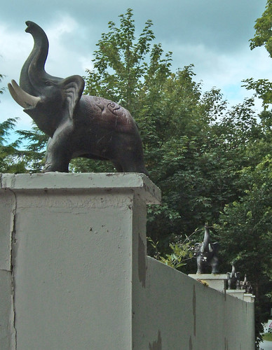
One of the houses, Toby Cottage, has a rather surreal display of trumpeting elephants around the top of its wall.
The route emerges on the A30, a second encounter with this road if you've arrived at Sunningdale station and retraced the link back to the main route. A little along the road is a building that was obviously once a pub -- in fact the Red Lion, which Countryway creator Keith Chesterton describes in 1981 as "an ordinary workaday pub with a good public bar, no carpets, some food and plenty of room." It's now Bluebells, an upmarket "restaurant and garden bar" with a menu that includes canapés, amuses bouches and homemade breads -- I suspect they've also invested in some carpets. At least it hasn't been converted into private homes.
As you'll note from a "Welcome to..." roadsign, Bluebells is bang on the boundary of the Surrey borough of Runnymede, and the bridleway I pick up next to the restaurant runs along that boundary for a few metres but then keeps within Windsor and Maidenhead. The bridleway bisects the grounds of the Coworth Park Estate, which was controlled by Westminster Abbey after the Norman Conquest. The mansion now at its heart was built in 1776 for East India merchant William Shepheard. After a 20th century stint as a convent school (the successor of which is now at a different site nearby but, confusingly, still called Coworth House), it was redeveloped by package holiday pioneer and polo enthusiast Harold Bamberg as a polo centre and luxury residential estate.
It's a curious place: on one side of the drive is a large polo field where, on my visit, a handful of mounted players were riding about to an enthusiastic Australian-accented amplified commentary. On the other, behind ponds and moats, is a cluster of modern residential buildings in a collection of fake rustic styles: a miniature castle, some half-timbered cottages. Its close proximity to the Great Park is not accidental, given the Royal enthusiasm for this odd equestrian team sport, a more modern, formalised substitute for the thrill of the chase and the cavalry charge. The game is actually Iranian and clearly military in origin, coming to Britain via Pakistan during the days of Empire.
Through the gates of Coworth Park I'm already facing the southern fence of the Great Park on the other side of the A329. The route enters the area of the park through Blacknest car park a little on the left, and immediately we're in the Royal Landscape, and a short stroll through the trees from its most dramatic and iconic feature, the large artificial lake of Virginia Water.
Created in the 174os by damming the river Bourne and flooding the area, and once the biggest artificial body of water in the British Isles, it is the most obvious legacy of the Duke of Cumberland's tenure as Ranger, although originally it was smaller -- the current extent dates from the restoration of the lake following a flood in the 1768. The transformation of the southern park took place during a time of change not only in the economics of Crown lands but of the aesthetics of open space. Traditionally spaces intended for relaxation and enjoyment, as opposed to wild or agricultural areas, wore their artificiality on their sleeve, as if celebrating human triumph over nature for the sake of pure sensual pleasure, for example the magnificent formal gardens of Versailles. But the 18th century saw the emergence of what's broadly characterised as the Romantic movement, in which natural or agricultural environments, previously dismissed, disdained or fearfully respected, were now celebrated for their beauty, and landscape design took on a whole new vocabulary of fake nature.
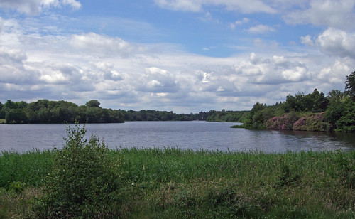
So Virginia Water tries hard to look like a Scottish highland loch, as it turns out with some irony. This was also the period when the state was busy integrating Scotland into the United Kingdom following the Union of Parliaments in 1707, and British monarchs were discovering a taste for affecting the personae of highland lairds. The uglier side of that process was the quashing of remaining resistance in the highlands. The Terraformer of Windsor is better known to history as the Butcher of Culloden -- Park ranger Cumberland no doubt distracted himself with taking note of the Scottish landscape in between leading the troops that brutally and ruthlessly annihilated the Jacobite Rebellion led by Charles Edward Stuart in 1746.
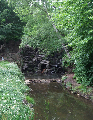
What the lake lacks is the mountain backdrop -- which, if you're a film maker wanting to stay within a stonesthrow of London and not have to battle with voracious midges, can always be added in with CGI. Scenes from some of the Harry Potter films were shot here, adding more layers of fakery since these films are largely set in a mythical English 1920s public school that's been magically transplanted through time and space to contemporary Scotland without ever becoming recognisably Scottish. Preparations for filming are in progress during my visit: there's a small galleon-style sailing boat moored on the opposite bank, and a little further along a castle and jetty set has been built on the site of the Fishing Temple, once a destination for royal picnics. The artificial waterfall known as the Cascade, at the southeast corner of the lake where the Bourne narrows into a stream again, also gives the impression of a set -- it's attractive, but the massive blocks of stone quarried on Bagshot Heath might as well be Star Trek polystyrene.
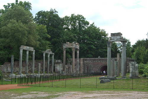
A fine surfaced path runs along the lake shore, a circuit of just over 7km, and a little east, on a headland with benches looking across to an arm of the lake past the fishing temple, it crosses the boundary into Surrey and Runnymede, though as the park has for centuries been managed as one unit under a single ownership, administrative boundaries have little relevance. A little further along are some classical ruins with spindly columns, the remains of a Roman temple brought here from the ancient city of Leptis Magna near Tripoli, Libya, in 1818, at the behest of the Prince Regent, later George IV.
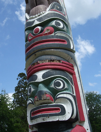
It's a guilty pleasure of living in a former Imperialist heartland that you have easy access to an eclectic range of artifacts pillaged from around the world, and there are many more such examples in the park. Having followed the shore east then northwards past the main car park where hundreds of day trippers and picnicers are currently disgorging into the fine sun of a June Sunday, I leave the waterside towards the incongruous site of a 100m-high totem pole, erected to mark the centenary of British Columbia in 1958. It was carved by sculptors from the Kwakiutl First Nation from a single redwood tree log from the Queen Charlotte Islands, 800km north of Vancouver. An information board identifies the various carved figures, starting at the bottom with the Cedar Man, the spirit of the tree.
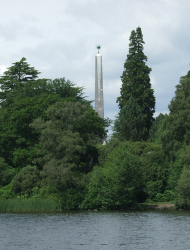
At this point, Chesterton's 1981 directions become difficult to follow, thanks I think to management changes which have seen some connecting paths shut off, but I find my own way, through landscaped areas of rhodedendrons. Look at their roots, though, and you'll sport patches of sandy soil, telltale signs of the heath that underlies all this manicured cultivation. I wander up to another, smaller body of water, the Obelisk Pond, so called since over the other side of it is another tall commemorative structure, though rather less impressive than the totem pole -- an obelisk in honour of Cumberland. It originally bore the inscription CULLODEN until Victoria, the canniest and most enthusiastic developer of a Scottish identity for the British Royals, had it censored.
Nearby are two of the park's most popular features, the Valley Gardens and the Savill Gardens, created in the 1930s, the latter now with an impressive 2006 visitor centre building, but I pass these by.
A green strip then runs beside a large field, Smiths Field, which has been a deer park, a heath grazed by sheep and a wartime airfield and is now our second polo field of the day, towards a gate that marks the limit of the Royal Landscape and the entrance to the contemporary deer park. The gate with its distinctive red lanterns is Cumberland Gate, though the cottage beside it, confusingly, is not Cumberland Lodge.
This turns out to be a much grander house a little further along, originally built as Byfield House during the all-too-brief period of the English republic when Oliver Cromwell confiscated and redistributed royal lands. It then became the official Ranger's residence and was once occupied by Cumberland himself. In the grass and trees beyond the gate the route makes it final farewell to the county of Surrey, though there's nothing to mark it on the ground.
A plaque identifies a tree as planted by Prince Christian Victor of Schleswig-Holstein, a political entity more distantly defunct than Berkshire, to commemorate his coming of age in 1889. Only 11 years later he died of enteric fever n South Africa. A rather longer-lived royal was Elizabeth Bowes-Lyon, better known as the Queen Mother, who a little further on is commemorated by an avenue of lime trees planted to mark her 100th birthday.
Near Cumberland Lodge is a complex junction of paths and drives with a view over the more open landscape of the deer park, with rough grass, woodland patches and ponds, something of the character Herne might recognise, with the model Village built to house estate workers in the 1930s off to the left. Joining from this direction, although not signed on the ground, is the Three Castles Path, a well-established but largely unsigned route 100km running southwest-northeast across Berkshire and Hampshire, linking Windsor and Winchester via King John's castle at Odiham and devised by East Berkshire Ramblers. A later part of the route uses another section of the Basingstoke Canal, familiar from the last Countryway section. We'll be sharing the northeast extremity of the route all the way to Windsor Castle.
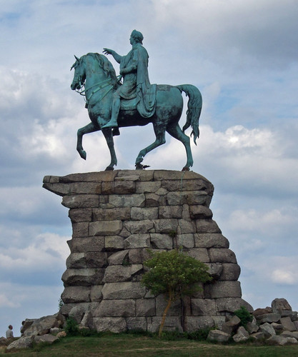
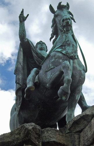
A surprisingly modest unsurfaced path leads from here more-or-less directly to the park's best known landmark, the so-called "Copper Horse". The path opens out into a broad swathe of grass and there it is ahead, atop Snow Hill, a massive statue of George III on horseback by Richard Westmacott on a rugged stone plinth, placed here by his son George IV in 1830. The king is depicted as a heroic Roman emperor -- with some irony for a pragmatic man who colluded in limiting the powers of the monarchy. There's another irony, probably deliberate, in the inscription PATER OPTIMO, "the best of fathers", as the two Georges' relationship was stormy at best. The huge scale of the piece and its po-faced heroic register in this dramatic setting have a heavy seriousness that undermines itself in a way that's almost camp, and I'm sure was a source of waspish amusement to the man who commissioned the Brighton Pavilion.
The Thames Valley reveals itself as you reach the top of the hill, and the statue is a great place to have lunch, with breathtaking views across the the Chilterns and east towards London, and a succession of planes taking off westwards from Heathrow overhead. Off to the right an expanse of water is the Queen Mother Reservoir -- a notion I find almost as inappropriate a tribute as the Queen Mother Sports Centre in Vauxhall Bridge Road. Beyond it you can just about spot Canary Wharf, our first sight of it for some time. Immediately ahead is Windsor Castle and its surrounding town, at the end of the dead straight ribbon of the Long Walk that stretches out from the bottom of the hill. It's rare to have such a clear view of the next 5km of your route, and not entirely encouraging.
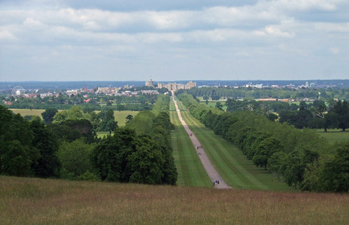
As Chesterton says, once you've set out on the Long Walk, you may well reflect that it's aptly named. It was created by Charles II, who planted a double avenue of elms, partly as a way of integrating a recent purchase of land in the immediate vicinity of the castle that originally hadn't belonged to the Crown, now known as the Home Park, to connect castle and estate in a way that hadn't previously been possible. In the 20th century the elms fell victim to disease and now the broad drive is flanked by chestnuts and London planes. Beyond the trees to the left, a large herd of deer are grazing, though staying well away from the well-used Walk.
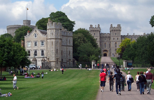
Gradually, imperceptibly, the view of the castle enlarges ahead, its asymmetrical appearance, with the round keep flying the royal standard off to the left and a wing of apartments stretching rightwards from it, familiar to anyone who's ever sat through the Queen's Christmas broadcast waiting for Top of the Pops. The keep dates from the 1350s, when the castle still had a defensive rôle, but following the restoration of the monarchy in 1660 the site underwent a long process of redevelopment as a luxury residence, originally planned to rival Versailles, a process paralleling that of the park. It still claims to be the largest and oldest still-inhabited castle in the world, but really it's more of a stately home, and a visitor attraction, the popularity of which has soared since it was restored following a devastating fire in 1992. Despite the visitors, it's still popular with the royals, who rebranded themselves after it during World War I when something a little more English than "Saxe-Coburg-Gotha" was considered appropriate.
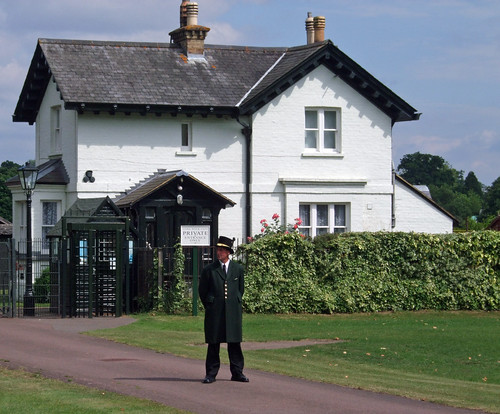
Eventually I cross busy Albert Road -- I'm amazed no controlled crossing nor even so much as a raised speed table has yet been installed since Chesterton's book, especially since it's only a few metres from a 50mph limit and on such an historic route alignment -- and enter the home stretch through the Home Park, where a quaintly uniformed officer guards one of Albert's model farms off to the right.
The surroundings now have more of an urban park feel, but it's still a stride before I confront the railings blocking the final section to the castle itself and head off left straight into Windsor.
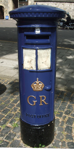
In the shadow of the castle, next to the old post office and an ancient well, I pass an intriguing blue-painted pillar box, one of the few remaining 1930s boxes intended for airmail. It's now out of use, but it's been kept partly because the Long Walk was the terminus of Britain's first air mail flight, delivering mail from Hendon to commemorate George V's coronation.
The original village, 3km to the south, is now called Old Windsor -- "new" Windsor is the Thamesside town that grew up around the castle, which became a prosperous borough partly through links with the royal household. Today those links underwrite the town's prosperity as a tourist destination. It's the biggest urban area I've entered on this walk since Sevenoaks, and the first significant town actually on the main Countryway route since leaving Gravesend, appropriately also on the Thames. It's a bustling place on this fine summer Sunday and I'm enjoying the change of walking on crowded pavements.
Interpreting Chesterton's route rather liberally, I duck down cobbled Market Street by the 1680 Guildhall that juts out into the road. There's an elaborate wedding going on involving a white Rolls Royce -- it's a popular spot for them since Prince Charles and Camilla Parker-Bowles got hitched here.
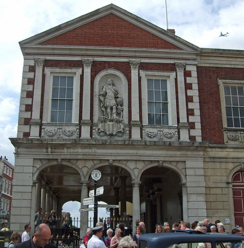
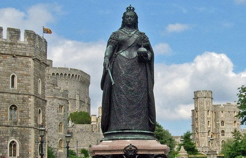
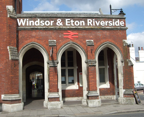
I wind back to the High Street past a black statue of Victoria at her grimmest that guards Castle Hill, pass the grand entrance to Central station, where we'll be arriving next time, and find an intriguing passage, Boots Passage, beside the Wetherspoons pub, surmounted by a mustachioed bust of Edward VII. The level is dropping towards the river, so I cut off through a car park and past public toilets in what appears to be a converted house, decorated inside with twee murals of Victorian Windsor. I glimpse the pedestrian bridge over to Eton which I'll be crossing on the next stage, and keep on ahead to Riverside station on the next corner.
Both stations date from 1849, a legacy of competition between the Great Western Railway, which extended its line from Slough to Windsor & Eton Central, and the London and South Western Railway extending from Staines to Windsor & Eton Riverside. Today the twin stations mark Windsor as on the boundary between two modern rail franchises, First Great Western from Paddington to Central and South West Trains from Waterloo to Riverside. The latter is a more modest but attractive station, all chunky red brick and pointed Gothic arches.
The concourse is a pleasant place to chill with a coffee, and not without interesting features, including a curious engraved plaque with Windsor scenes and a stylised map. Near it is an information board about walks from stations in Berkshire, sponsored by Thames Trains and Berkshire County Council, neither of which still exist. The park, the castle and -- a treat for next time -- the river, luckily have a little more continuity.
View a maphttp://maps.google.co.uk/maps/ms?ie=UTF8&hl=en&oe=UTF8&num=200&start=146&msa=0&msid=117966169375523396049.00046414d40d8252e7b70&ll=51.394654,-0.624161&spn=0.025385,0.055189&t=h&z=14
Route description pdf
More information
- Royal Borough of Windsor and Maidenhead http://www.rbwm.gov.uk/
- Windsor Tourism http://www.windsor.gov.uk
- Windsor Parks and Open Spaces http://www.rbwm.gov.uk/web/parks_openspaces.htm
- Windsor Public Rights of Way http://www.rbwm.gov.uk/web/prow_index.htm
- David Nash Ford's Royal Berkshire History http://www.berkshirehistory.com/
- Sunningdale Parish Council (including walks) http://www.sunningdale-pc.org.uk/
- Waterloo to Reading Line (Wikipedia) http://en.wikipedia.org/wiki/Waterloo_to_Reading_line
- A30 (Wikipedia) http://en.wikipedia.org/wiki/A30_road
- Bluebells Restaurant http://www.bluebells-restaurant.co.uk/
- The Polo Centre at Coworth Park http://www.thepolocentre.com/
- The Crown Estate http://www.thecrownestate.co.uk
- Windsor Estate (Crown Estate) http://www.thecrownestate.co.uk/our_portfolio/windsor_estate.htm
- The Royal Landscape http://www.theroyallandscape.co.uk/
- Surrey County Council http://www.surrey.gov.uk
- Surrey Countryside http://www.surreycc.gov.uk/countryside
- Surrey Interactive Maps http://surreymaps.surreycc.gov.uk/
- Visit Surrey http://www.visitsurrey.com/
- Runnymede Borough Council http://www.runnymede.gov.uk
- Runnymede Parks, Gardens and Walks http://www.runnymede.gov.uk/portal/site/runnymede/menuitem.58d4f989924165a4f289e71030008a0c/
- Old Windsor Parish Council http://www.owpc.co.uk/
- East Berkshire Ramblers (Three Castles Path) http://www.eastberksramblers.org/
- Windsor Home Park (RBWM) http://www.rbwm.gov.uk/web/parks_home_park.htm
- The Royal Collection http://www.royalcollection.org.uk
- Windsor Castle (Royal Collection) http://www.royalcollection.org.uk/default.asp?action=article&ID=34
- National Trails http://www.nationaltrail.co.uk
- Thames Path National Trail http://www.nationaltrail.co.uk/Thamespath/
- Slough to Windsor and Eton Line (Wikipedia) http://en.wikipedia.org/wiki/Slough_to_Windsor_%26_Eton_Line
- Staines to Windsor Line (Wikipedia) http://en.wikipedia.org/wiki/Staines_to_Windsor_Line


5 comments:
Well I never knew there was so much of note to see in and around Windsor. I am passing through that area next week and will now stop to check out some of your suggestions. Thanks.
Pleased to be of help! Enjoy Windsor.
I have family in Windsor so I've visited a few times but haven't seen as much as you have written about. I hope to have time in the future to make a stop at some of the places that you have suggested.
According to a notice by the totem pole, it has reached the end of its lifespan, will be lowered in spring 2025, and is already fenced off in preparation for this. It will be laid horizontally somewhere else in Windsor Park to decay, and an alternative attraction, currently undecided, put in its current location.
Thanks for the update, Jon, and glad it'll still be on public show in some way, at least until it decays completely!
Post a Comment