 |
| London's own chalk down: Farthing Down |
IF THE LAST LONDON LOOP SECTION was mainly about woodland, this one is mainly about chalk. The trail works its way around the white cliff of a chalk quarry, crosses several chalky commons and, in one of the most unlikely stretches on a London walk, strides along the spine of a fine chalk ridge, crossing the remains of prehistoric field systems with wide views to both sides. Then there’s the extra interest of a World War II airfield now protected as an ancient monument, a rare surviving cluster of smallholdings built for returning servicemen, a fine park that played a major role in horse-racing history, a high security prison and London’s only lavender farm.
This walk covers two consecutive Loop sections but as both are relatively short I’ve treated them together. You can of course tackle them separately if you wish, breaking your walk at the official end point of Coulsdon South station or at a number of other convenient points along the way.
Tracks through chalk
London’s longest and deepest roots are in its geology, reaching not only deep into the earth but a long way back in time. A very long way. The palaeozoic rocks of the ‘London Platform’, at the deepest levels beneath London, are more than 400 million years old. The next layer up, and the one that will interest us most today, was laid down during the Cretaceous period, 142-60 million years ago.
Back then, the tropical Tethis Sea washed over these rocks, and the calcium carbonate shed by microorganisms inhabiting that sea collected as a bed of what has now become chalk, a particularly pure form of limestone. This was later smothered by clays and gravels, and then, towards the end of the Cretaceous, between 60 and 40 million years ago, the tectonic plate carrying the continents of Europe and Asia rammed into the one carrying Africa.
The cataclysmic earth movements that resulted not only threw up the Alps, but bent and buckled our local rocks into the familiar shape of the London Basin. Subsequent millennia of erosion did the rest, exposing the underlying chalk as two chains of chalk ridges, the North Downs in the south and the Chilterns in the northwest, with the Thames flowing roughly west-east through the centre. There’s an eastern rim too but much of it is submerged by the Thames estuary, and beyond these rims a much bigger system of chalk deposits that covers large parts of southern and eastern England and stretches to Champagne in France.
The vast timescales involved make these events seem completely remote from human history. People likely didn’t appear in the London area until about 42,000 years ago, just before the last glacial period, when Britain was still connected to the mainland. With only limited technology, they made very little impression on the landscape, and almost certainly retreated again to warmer parts of Europe when the ice sheets rolled south as far as Hornchurch. This glaciation also had a dramatic effect on the site of the future city, forcing the Thames away from its old course through the Vale of St Albans onto the more southerly route it follows today. As the land began to warm again about 12,000 years ago, humans returned, and found themselves islanders when rising sea levels from the melting ice severed Britain from Europe.
Geology and geography shaped the course of London’s human history. It’s not hard to see how the broad navigable river and its surrounding marshes determined both the strategic importance and the overall shape of the city. The fertile lands either side of the river and the stripes of chalk beyond them, easily accessed via tributaries, provided a particularly favourable patchwork of environments where human activity could flourish.
The vast timescales involved make these events seem completely remote from human history. People likely didn’t appear in the London area until about 42,000 years ago, just before the last glacial period, when Britain was still connected to the mainland. With only limited technology, they made very little impression on the landscape, and almost certainly retreated again to warmer parts of Europe when the ice sheets rolled south as far as Hornchurch. This glaciation also had a dramatic effect on the site of the future city, forcing the Thames away from its old course through the Vale of St Albans onto the more southerly route it follows today. As the land began to warm again about 12,000 years ago, humans returned, and found themselves islanders when rising sea levels from the melting ice severed Britain from Europe.
Geology and geography shaped the course of London’s human history. It’s not hard to see how the broad navigable river and its surrounding marshes determined both the strategic importance and the overall shape of the city. The fertile lands either side of the river and the stripes of chalk beyond them, easily accessed via tributaries, provided a particularly favourable patchwork of environments where human activity could flourish.
The high chalk ridges, when cleared of their natural tree cover, provided poor soils but good grazing land and commanding, strategic sites for settlements. They also formed a natural network of long distance routes for trade and migration, and the ancient trackways along them, most of which are now either tarmac roads or much-valued recreational paths, are some of Britain’s oldest highways. As it says in the City of London’s plan for Farthing Down, chalk downlands are “an integral part of our physical and cultural heritage.”
The Chiltern Hills lie some distance beyond Greater London to the northwest and are only glimpsed later in the Loop, but the North Downs are much closer by. The main ridge at one point forms the boundary of the London Borough of Bromley and subsidiary ridges perpendicular to the main one extend into Bromley, Croydon and Sutton. In fact since Scadbury the Loop has been working its way through the London’s Downlands area of the All London Green Grid, one of the Mayor of London’s strategic planning designations. You will already have seen chalk underfoot and felt the rise and fall of the land, but woodlands and houses have obscured the view. Things are about to get a little more exposed and obvious.
And if you’re puzzled as to why something that goes up is known as a ‘down’, the word has a different etymology than ‘down’ as the antonym of ‘up’ and just happens to have ended up as a homophone and homograph. It’s from an Old English word dūn meaning ‘hill’, which also gave rise to the term ‘dune’.
The Chiltern Hills lie some distance beyond Greater London to the northwest and are only glimpsed later in the Loop, but the North Downs are much closer by. The main ridge at one point forms the boundary of the London Borough of Bromley and subsidiary ridges perpendicular to the main one extend into Bromley, Croydon and Sutton. In fact since Scadbury the Loop has been working its way through the London’s Downlands area of the All London Green Grid, one of the Mayor of London’s strategic planning designations. You will already have seen chalk underfoot and felt the rise and fall of the land, but woodlands and houses have obscured the view. Things are about to get a little more exposed and obvious.
And if you’re puzzled as to why something that goes up is known as a ‘down’, the word has a different etymology than ‘down’ as the antonym of ‘up’ and just happens to have ended up as a homophone and homograph. It’s from an Old English word dūn meaning ‘hill’, which also gave rise to the term ‘dune’.
 |
| Trig point, Sanderstead to Whyteleafe Countryside Area |
Sanderstead to Whyteleafe Countryside Area
As at the end of the previous section, the London Loop continues west from Hamsey Green along the Greater London boundary: the right (north) side of evocatively named Tithepit Shaw Lane is in the London Borough of Croydon while the left side is in the Surrey district of Tandridge. Where the path swings off the street it leaves London, with the boundary following the house fences on the right. But oddly the land you now cross is owned by Croydon, even though it’s in Tandridge. This is the rather clumsily-named Sanderstead to Whyteleafe Countryside Area, an 80 ha cluster of public green belt land straddling the boundary, most of it under the ownership of one or the other council, with a patch belonging to educational charity the Whitgift Foundation.
The Loop strides out across a grassy meadow known as Dipsley Field on a plateau atop the Downs, along a bridleway known back in the 16th century as Broadway. It soon crosses back into London again, picking up the line of an ancient hedgerow along the top of Skylark Field. These meadows are supportive of flora and fauna fond of chalk grassland, including pyramidal orchids and rarities like greater yellow rattle, and the various land managers now cooperate to encourage greater biodiversity.
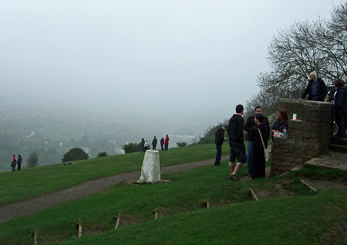
Look out on the left for a stumpy concrete pillar, 1.2 m high, with a square base and tapering sides. This is one of the Ordnance Survey’s triangulation stations, commonly known as ‘trig points’, the first encountered on the London Loop. It’s one of around 6,500 installed from the mid-1930s to help improve mapping accuracy. The idea was that each trig point was in line of sight of at least two others, so many were in high places, enabling comparative positions to be worked out using accurate sighting instruments like theodolites. The brass plate on top of the pillar with its distinctive three-armed indentation is there to receive such an instrument, and beneath the pillar is a chamber which contains geographical information.
Modern technology like GPS and laser sighting has rendered these objects obsolete and the Ordnance Survey no longer maintains them: some have been removed and some are now badly overgrown so the line-of-sight network has long broken down, but this one is still in relatively good condition.
The trail follows a hairpin-shaped course here, turning roughly west down the hillside into Riddlesdown. This 43 ha site is owned by the City of London, the first of four such green spaces along this section, and although adjacent to the Sanderstead to Whyteleafe Countryside Area isn’t officially part of it, for some obscure council designation reason. The name means ‘cleared woodland on the down’, which could also apply to much of the rest of the route.
Riddlesdown is dotted with prehistoric and Roman remains, and like much downland was managed for centuries as common land, making the best of its poor soil. It formed with neighbouring areas a single large common or ‘waste’ over which local people in the parishes of both Sanderstead and Warlingham, to the south, exercised rights to gather firewood and graze livestock. Riddlesdown itself formed part of the manor of Watendone, recorded in the Domesday survey as belonging to Chertsey Abbey. The name is variously modernised as Wattendon or Whattingdon, and has now largely fallen into disuse as a place name, though we’ll encounter a trace of it later.
Riddlesdown was saved in 1877 when a small local landowner, William Hall, refused to cooperate with lord of the manor Edmund Byron’s plans to inclose and develop it, successfully convincing a court that Byron had encroached on commoners’ rights. Hall then approached the City with a proposal that it bought the land, which it did, along with three other areas we’re about to cross, in 1883. Adjacent land was added in 1929, 1973, 1996 and 2006 to bring the site to its current size. Much of it was designated a Site of Special Scientific Interest (SSSI) in 1975 by virtue of its being the “largest single expanse of long-established calcareous scrub in Greater London”.
The trail follows a hairpin-shaped course here, turning roughly west down the hillside into Riddlesdown. This 43 ha site is owned by the City of London, the first of four such green spaces along this section, and although adjacent to the Sanderstead to Whyteleafe Countryside Area isn’t officially part of it, for some obscure council designation reason. The name means ‘cleared woodland on the down’, which could also apply to much of the rest of the route.
Riddlesdown is dotted with prehistoric and Roman remains, and like much downland was managed for centuries as common land, making the best of its poor soil. It formed with neighbouring areas a single large common or ‘waste’ over which local people in the parishes of both Sanderstead and Warlingham, to the south, exercised rights to gather firewood and graze livestock. Riddlesdown itself formed part of the manor of Watendone, recorded in the Domesday survey as belonging to Chertsey Abbey. The name is variously modernised as Wattendon or Whattingdon, and has now largely fallen into disuse as a place name, though we’ll encounter a trace of it later.
Riddlesdown was saved in 1877 when a small local landowner, William Hall, refused to cooperate with lord of the manor Edmund Byron’s plans to inclose and develop it, successfully convincing a court that Byron had encroached on commoners’ rights. Hall then approached the City with a proposal that it bought the land, which it did, along with three other areas we’re about to cross, in 1883. Adjacent land was added in 1929, 1973, 1996 and 2006 to bring the site to its current size. Much of it was designated a Site of Special Scientific Interest (SSSI) in 1975 by virtue of its being the “largest single expanse of long-established calcareous scrub in Greater London”.
 |
| Sussex cattle on scrub-replling duties at Riddlesdown |
The trail scrambles down some of that calcareous scrub to join a straight track known as Riddlesdown Road, the course of the old Roman road towards the south coast. Along the way you’ll likely encounter the Sussex cattle that roam freely across large parts of the hillside. Historically the site was likely continuously grazed for millennia but in the 1930s the practice ceased and trees began rapidly to recolonise the area, a process accelerated in the following decades as myxomatosis reduced the rabbit population. Fearing the loss of a unique environment, the City began clearing trees systematically from the 1980s, reintroducing livestock in 1989.
 |
| The Oxted Line about to tackle the chalk quarry at Riddlesdown |
The Roman road soon crosses and runs alongside a railway line which emerges from a 700 m tunnel beneath the down. This is the Oxted Line, built jointly by the London Brighton and South Coast Railway and the South Eastern Railway as the Croydon, Oxted and East Grinstead Railway in 1884. Beneath this, the old road merges with its modern successor, the A22 Godstone Road, which also runs to East Grinstead, connecting it with the A23 from London to Brighton at Purley, and continuing south across Ashdown Forest and the South Downs to Eastbourne. It owes its current alignment to the London to East Grinstead Turnpike Trust, created to improve it in 1718.
The road runs along what is actually the valley of the river Bourne, which, as its name suggests, spends most of its time underground. It rises in Woldingham and flows along this valley via Purley to Croydon where it feeds Waddon Ponds and the river Wandle (which we’ll eventually visit on the Wandle Trail). Another source rises in Coulsdon to a confluence at Purley, and the underground stream that runs through Sparrows Den at West Wickham in the last section is a further tributary.
The road runs along what is actually the valley of the river Bourne, which, as its name suggests, spends most of its time underground. It rises in Woldingham and flows along this valley via Purley to Croydon where it feeds Waddon Ponds and the river Wandle (which we’ll eventually visit on the Wandle Trail). Another source rises in Coulsdon to a confluence at Purley, and the underground stream that runs through Sparrows Den at West Wickham in the last section is a further tributary.
Unlike several well-known ‘lost’ rivers closer to central London, the Bourne wasn’t deliberately buried: such phenomena naturally occur in chalk landscapes, though in places the river’s course has been deliberately diverted through pipes and culverts. Indeed many locals are unaware of their riparian location, until the Bourne forcefully makes its presence felt by flooding, as it has done during prolonged periods of wet weather in recent years. Early in 2014 part of the river had to be diverted into fields to avoid it inundating the Kenley sewage treatment works and causing serious pollution.
The land use pattern here is a classic example of ribbon development: the road and two separate railway lines squeeze into the narrow valley between two high downs, and the housing cling to them like moulds along a trail of sugar. Whyteleafe, the area just to the south, was farmland in the parishes of Caterham, Coulsdon and Warlingham until 1855, when someone built a posh house in a field known as White Leaf Field after the distinctive foliage of the whitebeam trees that grow locally. Doubtless the people who developed this strip in subsequent decades thought a prettier spelling would add a few quid to the house prices.
The more rustic past is recalled in the name of Old Barn Lane, the street that takes the Loop onwards across the valley. Once again you’re walking on the boundary of Greater London, and once again there’s no clear reason for this except for the old parish line between Caterham (Tandridge, Surrey) on the left (south) side and Coulsdon (Croydon, London) on the right. The lane is interrupted by a second railway line, the Caterham Line. This actually predates the Oxted Line: it was originally built as the Caterham Railway, a branch from the Brighton main line at Purley, in 1856, although Whyteleafe station wasn’t opened until 1900, when the development of the area was well-advanced.
The land use pattern here is a classic example of ribbon development: the road and two separate railway lines squeeze into the narrow valley between two high downs, and the housing cling to them like moulds along a trail of sugar. Whyteleafe, the area just to the south, was farmland in the parishes of Caterham, Coulsdon and Warlingham until 1855, when someone built a posh house in a field known as White Leaf Field after the distinctive foliage of the whitebeam trees that grow locally. Doubtless the people who developed this strip in subsequent decades thought a prettier spelling would add a few quid to the house prices.
The more rustic past is recalled in the name of Old Barn Lane, the street that takes the Loop onwards across the valley. Once again you’re walking on the boundary of Greater London, and once again there’s no clear reason for this except for the old parish line between Caterham (Tandridge, Surrey) on the left (south) side and Coulsdon (Croydon, London) on the right. The lane is interrupted by a second railway line, the Caterham Line. This actually predates the Oxted Line: it was originally built as the Caterham Railway, a branch from the Brighton main line at Purley, in 1856, although Whyteleafe station wasn’t opened until 1900, when the development of the area was well-advanced.
 |
| The White Cliffs of Croydon: looking back on Riddlesdown Quarry from New Barn Lane, Whyteleafe. |
Look behind you from the railway footbridge and you’ll see why the Loop followed such a roundabout hairpin. Directly in your line of site is a big chalk cliff, like a miniature version of the celebrated white cliffs that line parts of the south coast. This one wasn’t eroded by the English Channel: instead it was carved by quarrymen in search of chalk to turn into lime for building materials and industrial chemistry.
Locals dug chalk informally at what came to be known as Rose and Crown Pit back in the 18th century, and in the 1820s a dedicated lime works was opened on the site, later bought by Blue Circle Cement. Quarrying ended in 1964, and the City of London bought the 3.7 ha site in 1996. The exposed chalk, which the Oxted Line traverses on an elegant brick viaduct, is not only dramatic to look at but also supports rare species and reveals layers of great interest to geologists, and the quarry is now classed as a Regionally Important Geological and Geomorphological Site. But it’s closed to the public for health and safety reasons.
What goes down must go up, and on the other side of the valley you’ll confront one of the trail’s most bracing climbs, a flight of 82 steep wooden steps up to Kenley Common. A sign indicates these were installed by the Downlands Countryside Management Project, a name we’ll encounter again. Do reward yourself with a glance backwards for an even more spectacular view across the valley to the white cliffs of Croydon.
What goes down must go up, and on the other side of the valley you’ll confront one of the trail’s most bracing climbs, a flight of 82 steep wooden steps up to Kenley Common. A sign indicates these were installed by the Downlands Countryside Management Project, a name we’ll encounter again. Do reward yourself with a glance backwards for an even more spectacular view across the valley to the white cliffs of Croydon.
Kenley and Coulsdon Commons
 |
| The Kenley Airfield Tribute, against the backdrop of preserved blast pens from World War II. |
Kenley Common is a further 56 ha stretch of the old waste of Wattendon bought by the City of London from the lord of the manor in 1883, by which time it was already separated from Riddlesdown by the development along the Bourne Valley. Its subsequent history turned out to be rather more dramatic.
Much of the original common is a flat plateau 170 m above sea level. Alongside its location close to London and not far from the south coast, it was the perfect site for a military airfield, so was requisitioned for this purpose by the Ministry of Defence (MoD) for the Royal Flying Corps, predecessor of the Royal Air Force (RAF), in 1917, towards the end of World War I – initially amid much local opposition. It was maintained as an operational airfield in peacetime, rumoured to be because Winston Churchill was learning to fly here, though the northern part was returned to the City, and the MoD also compulsorily purchased adjoining farmland on the east of the site which it passed onto the City in recompense.
The airfield was reactivated rapidly in 1939 and alongside Biggin Hill and Croydon airfields it played a key role in defending London during the Battle of Britain the following year. It continued in active operational use for fighter aircraft up to 1959, and in 1965 parts of the perimeter no longer required by the MoD were returned to the City, which also bought further non-airfield land nearby in 1983 and 2004.
Today the core of the airfield is retained by the MoD and used by the RAF volunteer gliding squadron and air cadets, though powered flights have long since been banned. Although much of the World War II infrastructure has gone, the runways, taxiways and some key structures remain. It’s regarded as the best preserved of the Battle of Britain airfields, and is now a Conservation Area and a Priority Archaeological Zone, with several of its features designated Ancient Monuments. You can now wander at will even into MoD territory, so long as gliding isn’t in progress.
The airfield site is just off the route though it’s worth making a detour, and if you really want to explore, there’s a heritage trail complete with recently installed information boards in the shape of Spitfire wings. The Loop first skims woodland on the extreme north of the common and then crosses a more open area where cattle sometimes graze: the northwestern end of the airfield site is just a little to the south here. Sticking to the trail you follow Golf Road, an unsurfaced and rather exclusive residential street with a name that recalls the golf course which occupied part of the common prior to 1917.
The Loop then crosses the 12 ha Betts Mead Recreation Ground, not part of the common but one of Croydon council’s green spaces, a stretch of grass and scraggy woodlands that originated in a gift from one Mr Betts, a philanthropic local, in 1925. On the other side of this and only a few steps off the path is the Wattenden Arms pub, one of only a few places to preserve the old manorial name. It’s mainly noted not for this but for its connection to the airfield. It was once the pilots’ favoured local, and still has a collection of photos and other memorabilia.
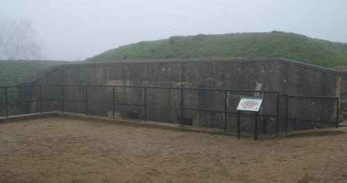
Next comes a ramschackle cluster of paddocks that once formed part of the airfield but are now used privately for grazing horses. The brick structure on the left here is the back of one of the E-shaped blast pens used to protect aircraft from bomb damage: the remaining examples on the site are scheduled ancient monuments.
The airfield site is just off the route though it’s worth making a detour, and if you really want to explore, there’s a heritage trail complete with recently installed information boards in the shape of Spitfire wings. The Loop first skims woodland on the extreme north of the common and then crosses a more open area where cattle sometimes graze: the northwestern end of the airfield site is just a little to the south here. Sticking to the trail you follow Golf Road, an unsurfaced and rather exclusive residential street with a name that recalls the golf course which occupied part of the common prior to 1917.
The Loop then crosses the 12 ha Betts Mead Recreation Ground, not part of the common but one of Croydon council’s green spaces, a stretch of grass and scraggy woodlands that originated in a gift from one Mr Betts, a philanthropic local, in 1925. On the other side of this and only a few steps off the path is the Wattenden Arms pub, one of only a few places to preserve the old manorial name. It’s mainly noted not for this but for its connection to the airfield. It was once the pilots’ favoured local, and still has a collection of photos and other memorabilia.
Next comes a ramschackle cluster of paddocks that once formed part of the airfield but are now used privately for grazing horses. The brick structure on the left here is the back of one of the E-shaped blast pens used to protect aircraft from bomb damage: the remaining examples on the site are scheduled ancient monuments.
 |
| Kenley Observatory |
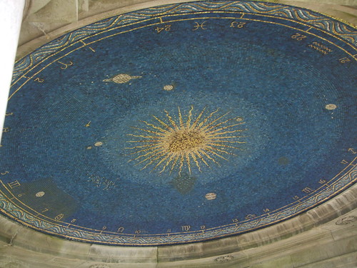
A white-domed building sticks out here like the proverbial sore thumb: this is Kenley Observatory, built piecemeal during the 1970s by Croydon Astronomical Society and opened in 1979. Observatories can’t be built just anywhere: they need somewhere with a clear view of the sky and low levels of ambient light, hard to find in a city, so the Society was lucky to have this site gifted to it in the 1960s. The building currently contains a powerful Meade LX-200 GPS Schmidt Cassegrain telescope and is open to the public most Saturday evenings during the darker months – though if you plan on visiting, be aware there’s no heating.
In the woods behind the observatory, a short diversion along a drive will take you to Hayes Lane, and the airfield on the other side. You’ll emerge only a little way along the concrete perimeter track from the RAF Kenley Tribute, a memorial installed in front of one of the preserved blast pens in 2000 as a millennium project led by the Kenley Airfield Friends Group. In this vast but quiet green space, where local people walk their dogs, it’s hard to imagine the scent of aviation fuel, the roaring of scrambling Spitfires and the screeches and thuds of enemy attacks, like the night of 18 August 1940 when all 10 hangers and 12 aircraft were destroyed.
The Loop crosses another ribbon of housing and climbs an increasingly rural lane to reach Coulsdon Common, the third of the 1883 City of London purchases. This has also subsequently expanded, mainly in the 1920s and 1930s, to encompass its current 51 ha. The site has a mix of environments including open downland and ancient woodland, but the trail largely passes through the secondary woodland of Stites Hill Wood – parts of this are more open ‘wood pasture’, a technique that in the past supported both forestry and animal husbandry on the same plot of land.
A windmill once stood on a site to the right (west) of this woodland path soon after it leaves Stiles Hill Road, and a circular stone now marks the spot. And if you’re a fan of coal posts, which once marked the limits of the City’s powers of taxation, you’ll find one off-route about 300 m left (southeast) along Coulsdon Road where the path emerges opposite Fox Lane. There’s one along Stiles Hill Road too. These are two of the closest such posts to the Loop: most of them are further out.
In the woods behind the observatory, a short diversion along a drive will take you to Hayes Lane, and the airfield on the other side. You’ll emerge only a little way along the concrete perimeter track from the RAF Kenley Tribute, a memorial installed in front of one of the preserved blast pens in 2000 as a millennium project led by the Kenley Airfield Friends Group. In this vast but quiet green space, where local people walk their dogs, it’s hard to imagine the scent of aviation fuel, the roaring of scrambling Spitfires and the screeches and thuds of enemy attacks, like the night of 18 August 1940 when all 10 hangers and 12 aircraft were destroyed.
The Loop crosses another ribbon of housing and climbs an increasingly rural lane to reach Coulsdon Common, the third of the 1883 City of London purchases. This has also subsequently expanded, mainly in the 1920s and 1930s, to encompass its current 51 ha. The site has a mix of environments including open downland and ancient woodland, but the trail largely passes through the secondary woodland of Stites Hill Wood – parts of this are more open ‘wood pasture’, a technique that in the past supported both forestry and animal husbandry on the same plot of land.
A windmill once stood on a site to the right (west) of this woodland path soon after it leaves Stiles Hill Road, and a circular stone now marks the spot. And if you’re a fan of coal posts, which once marked the limits of the City’s powers of taxation, you’ll find one off-route about 300 m left (southeast) along Coulsdon Road where the path emerges opposite Fox Lane. There’s one along Stiles Hill Road too. These are two of the closest such posts to the Loop: most of them are further out.
Happy Valley and Farthing Down
The Fox pub is in a pretty spot for a London boozer, surrounded by woods and bridleways on the edge of some of London’s most beautiful countryside, but in today’s circumstances it doubtless has to work hard to sustain itself, relying on drive-up custom and food. The pub was first recorded on the site in 1720 but like most such places it’s been rebuilt, and is now part of Mitchells & Butlers’ Vintage Inn chain, an independent village local no longer.
Officially the Loop follows the lane but it’s more direct to pick up the mowed path across a grassy corner of the common, passing a traditionally-styled drinking fountain installed in 2008 to replace a Portland stone original. From the bus stops on Coulsdon Road stretches a connecting arm of the Downlands Circular Walk, a 13.5 km signed trail shaped like an irregular triangle with our destination of Farthing Down at the apex and two sides linking to a stretch of the main ridge of the North Downs, which forms the base. This route has been around since the early 1990s, predating the Loop, and now provides the most straightforward link between our route and the North Downs Way National Trail.
The Downlands walk was one of the first public-facing efforts of the Downlands Countryside Management Project, also responsible for those challenging steps up the Bourne valley. The project was launched in the late 1980s as a partnership between numerous local authorities on both sides of the London boundary, the Surrey Hills Area of Outstanding Natural Beauty, the City of London and other relevant agencies to improve both management of and access to the countryside and green spaces along this stretch of the capital’s fringe.
Its employees’ enthusiasm for walking routes linking suburbia and countryside directly inspired the London Walking Forum which first devised the Loop, and was one reason why the southern section of our current trail was the first to be completed. The project has since metamorphosed into the Downlands Partnership, and its approach has gone on to influence the Green Grid planning process mentioned earlier.
Leaving Coulsdon Common the trail enters Croydon council’s Happy Valley open space and, for once, the expectations raised by the name will not be disappointed. At first the route follows Fox Lane, now a well-defined track through fields and woods which eventually leads to the isolated Chaldon church, taking the main route of the circular walk with it. But the Loop now swerves along the eastern rim of a dry chalk valley.
Leaving Coulsdon Common the trail enters Croydon council’s Happy Valley open space and, for once, the expectations raised by the name will not be disappointed. At first the route follows Fox Lane, now a well-defined track through fields and woods which eventually leads to the isolated Chaldon church, taking the main route of the circular walk with it. But the Loop now swerves along the eastern rim of a dry chalk valley.
 |
| Happy Valley, Coulson: aptly named. |
At first the surroundings are relatively intimate, small patches of rolling grassland divided by ancient hedgerows, but then through a gap in a hedge you find yourself at the corner of a long, broad, graceful groove in the landscape, lined with woodlands at the top of each bank. It’s one of those places where all the visual components fit together so perfectly you find yourself catching your breath, particularly in fine weather, and when the meadows are in flower.
Happy Valley somehow survived as farmland and woods right into the 1930s, and in 1937 101 ha of it was bought by the old Coulsdon and Purley Urban District Council under the original pre-war Green Belt scheme. At the time it was described as “one of the most beautiful valleys in the whole neighbourhood”, but it also provided a convenient green bridge between the City of London’s holdings at Coulsdon Common and Farthing Down, further along the trail. Originally known prosaically as the Coulsdon Green Belt Lands, in 1970 it was renamed Happy Valley Park, but is now referred to officially simply as Happy Valley to avoid the suggestion of a more formal space.
The valley is another area where the decline of traditional management in the 20th century threatened to undermine both visual appeal and distinctive ecology. Following the withdrawal of livestock and a drop in the rabbit population, scrub began to cover the grassland. A local farmer leased the land to grow hay for 10 years from 1956 but failed to do so, which made matters worse.
In the late 1960s, acting on advice from the local Wildlife Trust, the council began clearing much of the scrub. Now once again orchids and rattle flourish in the grasslands, over 25 species of butterfly flutter around, roe deer roam free, and dormice hide in the woodlands. But none of this is natural -–it's the result of a carefully-planned regime of timed hay cuts, grazing by sheep and goats as well as cattle, and a 15-year coppicing cycle in the woodland.
As well as the Loop, the circular walk and a nature trail marked with posts, a further long distance trail runs through the site. This is the Socratic Trail, an 80 km route linking Old Coulsdon church with Brighton, often with a choice of paths that also serve as circular walks. It was devised by local man Maurice Hencke on behalf of a small local long distance walking group based in Croydon, the Socratic Walkers, and the first guide, a homely collection of typewritten photocopied pages and hand-drawn maps, appeared in 1995. Hencke is no longer with us, but thankfully the trail is still walkable and a rather more professional-looking guide appeared in 2007. Despite rumblings from Croydon council in the late 1990s about adopting it as a millennium project, this particular route remains unofficial and unsigned.
The Loop crosses the valley (there’s some discrepancy here between the various maps and route descriptions about whether the Loop runs diagonally across or round the edges of the meadow, but the former is more direct) into Devilsden Woods, also part of the site. This is semi-ancient woodland dotted with old yews planted many years ago to demarcate boundaries.
Then the trail outdoes itself by climbing up from the woods and heading north straight down the spine of Farthing Down, also known as Fairdean Down. This is London’s biggest and most stretch of open downland, a bony finger pointing north from the main ridge towards Croydon. It’s a wonderful, bracing stride along the exposed and windswept down, with the springy turf typical of the downlands beneath your feet.
As well as the Loop, the circular walk and a nature trail marked with posts, a further long distance trail runs through the site. This is the Socratic Trail, an 80 km route linking Old Coulsdon church with Brighton, often with a choice of paths that also serve as circular walks. It was devised by local man Maurice Hencke on behalf of a small local long distance walking group based in Croydon, the Socratic Walkers, and the first guide, a homely collection of typewritten photocopied pages and hand-drawn maps, appeared in 1995. Hencke is no longer with us, but thankfully the trail is still walkable and a rather more professional-looking guide appeared in 2007. Despite rumblings from Croydon council in the late 1990s about adopting it as a millennium project, this particular route remains unofficial and unsigned.
The Loop crosses the valley (there’s some discrepancy here between the various maps and route descriptions about whether the Loop runs diagonally across or round the edges of the meadow, but the former is more direct) into Devilsden Woods, also part of the site. This is semi-ancient woodland dotted with old yews planted many years ago to demarcate boundaries.
Then the trail outdoes itself by climbing up from the woods and heading north straight down the spine of Farthing Down, also known as Fairdean Down. This is London’s biggest and most stretch of open downland, a bony finger pointing north from the main ridge towards Croydon. It’s a wonderful, bracing stride along the exposed and windswept down, with the springy turf typical of the downlands beneath your feet.
For extra atmosphere, you cross the humps and bumps of an ancient field system, low banks perpendicular to the main direction of the ridge built to separate small fields in the Bronze and Iron Ages. Further along, to the left of the main track along the ridge, are the remains of Saxon burial mounds from the 7th century. But look ahead and you’re brought back to contemporary London, as the towers of the City and Canary Wharf rear up in the distance. It’s an astonishing place, and a unique stitch in the capital’s patchwork.
The view of the City is appropriate as this is the fourth and last of the Coulsdon sites the City corporation bought from Edmund Byron in 1883. It was expanded with New Hill to the east in in 2002 and Woodplace Farm to the west in 2004, and now stands at 95 ha. Early farmers would quickly have exhausted the thin soil and it’s likely the down has been grazed continuously from Roman times, with a break between 1970 and 1993.
The view of the City is appropriate as this is the fourth and last of the Coulsdon sites the City corporation bought from Edmund Byron in 1883. It was expanded with New Hill to the east in in 2002 and Woodplace Farm to the west in 2004, and now stands at 95 ha. Early farmers would quickly have exhausted the thin soil and it’s likely the down has been grazed continuously from Roman times, with a break between 1970 and 1993.
Again the decline in grazing resulted in the rise of scrub: the current clumps of trees developed from patches of scrub left to provide variety during clearances in the late 1960s. Soon after cattle were reintroduced in the early 1990s, a local reported he’d seen aliens landing on the down while driving across it at night – this turned out to be the reflective bands place around the cows’ ankles so they would be seen in the dark. The site is now a scheduled Ancient Monument and, with Happy Valley, forms an SSSI.
The Loop runs in front of the cottages that once housed a tea room, closed in the early 1980s, and turns to follow the narrow road across the top of the down, itself an ancient trackway in origin. But I’ve suggested a route that runs for part of the way across the grass parallel to this on the west side, visiting the clump of trees known as the Folly, where a cairn marks the highest point and a plaque gives compass points. Both were installed in 2000 as a millennium project led by the local community, an initiative that eventually resulted in the creation of a Friends group. Finally the down declines and the trail descends with it to Coulsdon, passing another unexpected sight on a London walk: a cattle grid bookended with gateposts bearing the City of London crest.
The Loop runs in front of the cottages that once housed a tea room, closed in the early 1980s, and turns to follow the narrow road across the top of the down, itself an ancient trackway in origin. But I’ve suggested a route that runs for part of the way across the grass parallel to this on the west side, visiting the clump of trees known as the Folly, where a cairn marks the highest point and a plaque gives compass points. Both were installed in 2000 as a millennium project led by the local community, an initiative that eventually resulted in the creation of a Friends group. Finally the down declines and the trail descends with it to Coulsdon, passing another unexpected sight on a London walk: a cattle grid bookended with gateposts bearing the City of London crest.
Coulsdon
Coulsdon is an ancient parish, recorded in the Domesday survey, with much of its land owned by Chertsey Abbey up to the Dissolution, but it was a deeply rural area with only scattered settlement until suburban development began in the later 19th century. The area now known as Old Coulsdon, atop the hill by St John the Evangelist church, to the east of Farthing Down, was the original village centre. But even this was only “little more than a few groups of old cottages, the National schools and farm buildings, clustered round a green and duckpond,” according to a 1912 historian, plus some larger mansions for well-to-do business people. By this stage, though, the development of the rest of the area was proceeding apace. “Now there are continuous rows of villas and cottages and shops from Croydon to south of Coulsdon [South] station,” the same source states.
 |
| The old Brighton Road passes under the London & Brighton railway and the new A23 at Coulsdon South. |
As often, the arrival of the railway shifted the nucleus of the neighbourhood to its present site, on the flat lower ground to the north where three dry chalk valleys merged. This area was originally known as Smitham Bottom, and already carried an old highway, the London to Brighton road, predecessor of today’s A23/M23. Coulsdon’s railway age predated the steam locomotive: the Croydon, Merstham and Godstone Railway, a horse-operated goods line, opened in 1805 as an extension of the similar Surrey Iron Railway along the Wandle Valley from Wandsworth to Croydon, but this closed in 1838.
The London and Brighton Railway, still the main line between the two cities, opened in 1841, though Coulsdon South, originally known as Coulsdon and Cane Hill, didn’t appear until 1889. It was built by the South Eastern Railway (SER) which by now was operating services jointly with its competitor the London, Brighton & South Coast Railway (LBSCR) by order of parliament. A second railway, the Tattenham Corner Line, a branch line from Purley, passed through to the north in 1897, and a station on this followed in 1904. For most of its existence this station was known as Smitham but in 2011, following a public vote, the place name shift was confirmed when it was renamed Coulsdon Town.
Descending from the hillside, the small park on the other side of Marlpit Lane, Coulsdon Memorial Ground, is worth a look. It was opened in 1921 to commemorate the end of the World War I and includes a war memorial at the top of the slope. Some of the money was from the Hall family, who operated a chalk quarry behind the site, thus the street name. It now hosts a very pleasant park café.
London Loop Section 5 officially ends at Coulsdon South, one of the few stations that is conveniently situated on the trail itself rather than on a link route – the Loop passes over the footbridge between the platforms. The next section is one of the shorter ones, so I’ve decided to push on, but you could be forgiven for stopping. The walk so far has been outstanding, and what follows, though interesting, is notably less spectacular.
The A23 is notoriously one of London’s most congested trunk routes, with much of still following old high streets. At one point the M23 motorway was intended to bore deep into south London but thankfully this scheme was abandoned and the motorway now starts some way out. For most of the 20th century through traffic blighted Coulsdon, crawling past the station along Brighton Road. Since 2007, though, the A23 has been diverted to a viaduct above, but a milestone embedded in the wall just before the bridge recalls the old road’s former arterial function, advising you’re now “XIV miles [22.5 km] from Westminster Bridge, 37½ miles [60.5 km] to Brighton”.
 |
| The old Cane Hill psychiatric hospital, Coulsdon, as depicted by Michael J Weller for David Bowie |
Oddly, Cane Hill has several connections to celebrities. Hannah Chaplin, Charles’ mother, and Michael Caine’s brothers, were treated here. Perhaps most famously, David Bowie’s half-brother Terry Burns was an in-patient from the late 1960s to 1985, when he took his own life by throwing himself in front of a train at Coulsdon South station. If you want to know what the old asylum looked like, see the original US cover of Bowie’s 1970 album The Man Who Sold the World, where it’s depicted by his friend, cartoonist Michael J Weller.
Leaving Coulsdon the Loop crosses the Tattenham Corner Line and starts to climb again, although sadly not this time up open hillsides. The surroundings along Woodmansterne Road demonstrate what Farthing Down might have looked like if the City hadn’t intervened, with rows of identikit housing on one side, and a thick hedge concealing Woodcote Park Golf Course on the other.
Clockhouse and Woodcote
 |
| Carshalton Urban District Council boundary marker, Clock House, Sutton |
When Greater London was created in 1964, Woodmansterne village, and the farmhouse with the eponymous clock tower, since demolished, remained in Surrey, though the station and estate were folded into London. The station, which was effectively in Coulsdon, became part of Croydon, but the estate, with its links to Carshalton, was assigned along with the rest of the former urban district to Sutton. Thus the sign welcoming you to Sutton, the Loop’s fourth London borough, where the pavement runs out by the corner of the golf course. This is despite the fact that, thanks to the intervening green belt, the most direct link from the Mount to the rest of Sutton is via a bridleway. Most local children go to Croydon schools, but apparently local residents support the status quo.
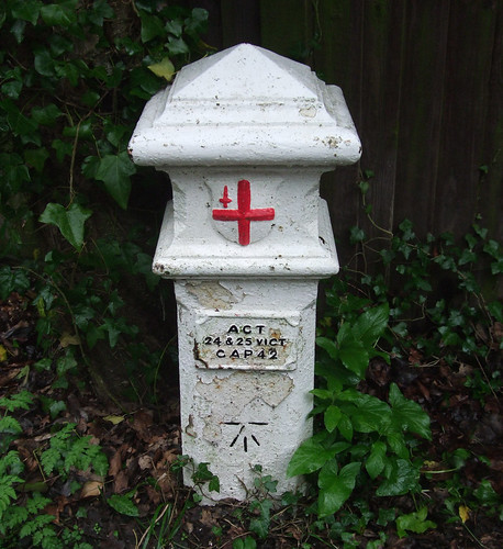
Just past the Mount you’ll find yourself on the aforementioned bridleway, walking past ancient hedgerows, where the Loop joins another Downlands Project trail, the Sutton Countryside Walk. Note the boundary marker – this path once demarcated two parishes and later Coulsdon & Purley and Carshalton urban districts – and a set of old gates to the Little Woodcote estate, now permanently open.
 |
| Homes fit for heroes: Little Woodcote |
One was lost in 2009 when Bill Lovett, who had been selling the produce of his 1.6 ha plot at Surrey Street market in Croydon for over 50 years, died at the age of 87. His daughter Vivien, a local historian, told the press at the time that only four smallholdings were left. The rest have inevitably become highly desirable private homes.
Across the fields on the other side are Ruffet Wood and Big Wood, which together form a Local Nature Reserve, but they’re not accessible from the path, only through the Clockhouse estate. Further on, rather than following the bridleway to the bitter end, the Loop diverts through a council-owned meadow around the back of The Pastures travellers’ site. A glance at the map shows this is a very roundabout route: it was originally put in place to avoid a difficult crossing and a busy road, but now there’s another delight in store.
 |
| Mayfield Lavender Farm, Woodcote |
The land to the south of busy Croydon Lane was once Oaks Farm, of which more later, but by the 1990s had become a rather neglected council-owned patch. Then along came Brendan Maye, an executive of a fragrance company with a passion for lavender, who tried to persuade his employers to revive growing the herb. When they rejected the idea, he set up on his own in 2002 under the name Mayfield Lavender, working organically in this field.
The Loop runs right through the middle on a right of way, but at certain times of year there’s permissive access to much of the rest of the farm, and a seasonal visitor centre, shop and café nearby. It’s yet another of the Loop’s delights to cross a stile from a busy road and find yourself in a field full of fragrant, colourful lavender, but also appropriate. The herb was once widely grown in the London area, including on this very site, and nearby Carshalton was known as the lavender capital of the world.
The Oaks Park
 |
| Formal gardens, The Oaks Park, Sutton. |
Smith-Stanley had a modest political career, but is best known for his sporting interests, and largely used the estate as a base for horse racing activities on the surrounding downlands. The Oak and the Derby, sweepstake horse races still run annually at Epsom not far away, were devised here in 1779 and 1780 respectively.
The estate was bought by Carshalton council in 1933 as a public asset, eventually passing to Sutton. Originally there was a large mansion, likely dating from the 1750s but with additions including some by Robert Adam, who gave it a castellated, Gothic look in the early 1790s. This house was used as a centre for child refugees from the Spanish Civil War in 1937 and later requisitioned by the military. By the 1950s it was in a dangerous state of disrepair and following much fraught debate at the council about the affordability of restoration was finally demolished in 1959. Several ancillary buildings remain, including the stables, which is now artists’ studios.
Today the Oaks is a generous 34 ha of public space including formal gardens, landscaped parkland, woods and open chalk meadows. The Loop barely scratches its surface, and it’s worth a more thorough exploration, perhaps by following the nature trail. Our route does at least pass through some of the formal gardens, including a rose garden, before ducking into the woodland surrounding the adjacent, and inevitable, golf course. There's also an active Friends Group.
The park is well-connected for walkers: as well as the nature trail, the Countryside Walk and the Loop there’s the Wandle-Oaks Link, a 3.5 km route that’s effectively a southwards extension of the Wandle Trail following the Wandle valley up to Wandsworth, linking the Oaks to the main trail at Grove Park in Carshalton. This provides one of the few straightforward walking links from the Loop into inner (and, via the Thames Path, central) London. National Cycle Network route 20 from London to Brighton also passes through.
On to Banstead Downs
 |
| Over the wall we go: Victorian asylum wall (foreground) and modern wall to High Down Prison. |
The low brick wall on the right once surrounded another asylum on London’s periphery, built by Middlesex County Council between 1873-77 on what was then open downland. At its peak, it housed over 2,500 people. Parts of it were used as a military hospital during World War II, and in the 1950s it also treated tuberculosis patients. It was closed in 1986 and the buildings largely demolished.
Beyond the Victorian wall, a second wall, a towering mass of smooth concrete supervised by CCTV cameras, gives a clue to the site’s current use. This is HM Prison High Down, opened in 1992, a ‘Category B’ local prison housing around 1,200 inmates “who do not require maximum security, but for whom escape still needs to be very difficult.” There’s also a second much smaller prison, HMP Downview, opened in 1989 on the north of the old asylum site, incorporating the former nurses’ home: this now houses adult women, with a separate female juvenile unit.
Thinking yourself fortunate for being on the right side of those walls, you’ll emerge on Sutton Lane and enter Banstead Downs, the Loop’s farewell to the North Downs. Mention of these chalky expanses goes back to the Domesday survey, when they were among the very many possessions of Archbishop Odo, whom we’ve already encountered around Orpington. Later they became part of the extensive common lands of Banstead parish.
It was Banstead Downs’ sporting associations that attracted the Earl of Derby to the area. They had been popular for racing and hunting since at least the early 17th century, and by the 18th century there was a race course connected via a long stretch of unbroken downland to the one that still exists at Epsom Downs. The various Banstead commons were protected by an act of parliament in 1893 which set up a board of Banstead Commons Conservators to manage them: this body still operates today, though much of the land is ultimately owned by the council. Much of the 174 ha site is now classified as an SSSI.
The downs had another claim to fame: the wool from their sheep was regarded as some of the very best in England. Welshman John Dyer (1699-1757), a vicar and minor poet now largely noted because William Wordsworth wrote a poem addressed to him, namechecks the area in his magnum opus The Fleece (1757), a rather laboured epic inspired by the wool industry:
…Wide airy downs
Are Health's gay walks to shepherd and to sheep.
All arid soils, with sand or chalky flint,
Or shells deluvian mingled, and the turf
That mantles over rocks of brittle stone,
Be thy regard ; and where low-tufted broom,
Or box, or berry'd juniper, arise;
Or the tall growth of glossy-rinded beech;
And where the burrowing rabbit turns the dust;
And where the dappled deer delights to bound.
Such are the downs of Banstead, edg'd with woods
And towery villas.
Dyer’s gay walking sheep disappeared on the outbreak of World War II, when much of the land was cultivated in the interests of self-sufficiently, and far too many of his burrowing rabbits succumbed to myxomatosis in the following decades, resulting int the familiar problem of scrub growth. Recently a few sheep have returned and some of the scrub cleared, but the site is still something of a patchwork.
 |
| Banstead station: Every day except Sundays. |
At the bridge the Loop crosses the Reigate and Banstead Millennium Trail from Belmont. This is a signed 28 km route running roughly north-south through the length of the borough and a little beyond, with some additional circular loops, created by the council as a millennium project with support from local walking groups and the Downlands Project. It provides the most straightforward link between the Loop and the London Countryway, which it meets, along with the North Downs Way, on Reigate Hill, one of the most spectacular viewpoints on the main ridge of the Downs. The trail then continues south across the Greensand Ridge and finishes just over the West Sussex boundary at, of all places, Gatwick Airport, making the latter the only official London airport with a recognised walking route connecting directly to the terminal.
The section of downland on the other side of the railway has been leased since 1890 to Banstead Downs Golf Club, although it’s still open to the public and now designated, along with the rest of the site, as access land, with the club obliged to manage it for conservation as well as sport. The Loop uses an old right of way across the course that crosses several fairways (three, if you include the link to the station) punctuated by strips of thick, scrubby secondary woodland. Amid one of these you’ll find the chunky fingerpost that directs you to the station.
On Sundays when there are no trains you’re best advised to venture into Banstead itself for the bus. The village centre is some way south of the station, which is actually closer to a neighbourhood known by the delightful name of Nork. Locals still insist that Banstead is a village and with its old well and green it preserves elements of a rural past, but the sprawl initially triggered by the arrival of the railway has turned it into a small town complete with familiar chain stores.
The spire of All Saints Church played a role in the development of accurate topography when, in the 1780s Anglo-French survey, a precursor of the Ordnance Survey, it was used as a landmark in plotting the precise distance between the observatories in Greenwich and Paris. Back then the spire could be sighted from Hounslow Heath, a feat which, as we’ll discover in the walk after next, would be rather more challenging today.
- Download full route description (PDF)
- View Google map
- View official Transport for London web page:
Hamsey Green - Coulsdon
Coulsdon - Banstead - Green Croydon For All: useful map of the borough's green spaces with interactive and PDF versions.





 Posts
Posts

