 |
| Murals under the arches of the Midland Main Bridge over the former Hatfield and St Albans railway. |
THIS INTRIGUING ALTERNATIVE ROUTE avoids the London Countryway’s long detour to the north of St Albans using secluded, traffic-free paths that weren’t an option when the main route was first devised. It runs from Verulamium to the south of the city centre, first along the river Ver and then on an old railway that’s now a cycling and walking route. It’s arguably less pretty and misses out some places of interest including St Michaels, Heartwood Forest, Sandridge and Hatfield Airfield. Neither will all walkers appreciate the long length of surfaced path. But the riverside section is charming, and disused railway lines with their remnants of infrastructure have their own special fascination.
I’ve also suggested a more direct alternative for the end
of this section from Roestock to Welham Green station on field paths and an old
lane. Again this misses out a couple of features including North Mymms church
and the swallow holes, but also avoids most of a particularly nasty stretch of
road walking. As the main and alternative routes share a central section from
Smallford to Roestock, you can walk either or both bits of each, saving a
maximum of 7 km.
The river Ver
 |
| The River Ver from the Ver Valley Walk at St Albans just south of the 'holy well'. |
The Ver is one of the main reasons the city of St
Albans is where it is, over the millennia providing water, food, transport and
power. The Romans built Verulamium on its south (right) bank, and the mediaeval
city grew up around the abbey on the opposite bank. This might seem puzzling
for what now appears to be a relatively modest and gentle river but back then
it was a much more copious stream, navigable by quite large boats.
Up to about 450,000 years ago the river Thames flowed
nearby, running northwards up the Colne valley and east across the Vale of St
Albans on its way to the Rhine. Then a glacier rolled onto the area that’s now
Hatfield, blocking the river’s course and creating a great lake to the west.
Eventually the water burst through at Staines to cut the course of the Thames
we know today, at the same time reversing the flow in the Colne valley, as the
Colne became a tributary of the Thames, and the Ver a tributary of the Colne.
The Ver is a chalk stream, fed by an aquifer formed by
rainwater sinking through the porous chalk of the Chilterns. Chalk streams are
rare – there are only around 200 in the world and most of these in England –
and they are particularly prized for their especially pure alkaline water which
supports unusual flora and fauna including the characteristic white tufts of
water crowfoot poking above the surface in spring. The official source is at
Kensworth Lynch on the edge of the Dunstable Downs in Bedfordshire, although
there’s a competing claim from Markyate Cell, just inside Hertfordshire. These
days the river is a ‘winterbourne’ upriver from Redbourn, north of St Albans,
with only a seasonal flow. South of the city it runs through Park Street to
join the Colne at Bricket Wood, a length of 27 km.
Human interference with the river’s course dates back at
least to the early mediaeval period with the cutting of mill races to power
water wheels. In its heyday the abbey claimed a local monopoly on milling and
its zealous assertion of this prompted locals to support the Peasants’ Revolt
in 1381. There were once at least a dozen mills on the 15 km stretch of the
river between Redbourn and Park Street including the main abbey mill, the
buildings and millstream of which are still visible adjacent to the Fighting
Cocks pub only a few steps from where our walk starts. Like most of its fellows
this originally milled grain but later became a successful silk mill, only
closing in the 1950s.
The river has also been diverted for landscaping reasons
and to create artificial water features like the lake in Verulamium Park, but
the main reason for the reduced flow today is exploitation for mains water. A
string of pumping stations have directly tapped the aquifer itself since the
early 19th century, with the water company now entitled to abstract
over 30 million litres per day. Unsurprisingly
there is some local concern and pressure around the issue. The Ver Valley Society was formed in 1976 with the support of the city council, initially to
help promote and develop the riverside walkway, but it soon also began to
campaign around water depletion, and has had some success in limiting pumping.
Between the lake and Holywell Hill the Ver has been
restored to a more natural condition, meandering gently through bankside
vegetation, quite a contrast to the formality of the lakeside. On the right,
across the grass towards the sports centre, a cluster of trees conceals one of
the now-controversial pumping stations, Mud Lane, which pumps around 2 million
litres daily.
Holywell Hill
Holywell Hill is the name for both the hill itself
and the steep and busy road running up it, the main route into the city from
the south. Watling Street continued in use as a road link to and from London and
northwest England for centuries after the Romans left, but it led through the
now-abandoned Roman city, not the mediaeval settlement around the abbey. In the
late 10th century Abbot Ulsinus stopped up the Roman road in an
effort to improve footfall past the abbey and its associated businesses by
forcing travellers from the north up the hill, continuing to London along
Sopwell Lane. The London-bound route was subsequently diverted twice more, in
the 16th century along Old London Road, and in 1794 along London
Road which now helps form the main crossroads in the city centre. Today long
distance traffic bypasses the city by some distance on the M1.
Despite variant historic spellings such as ‘Halliwell’ and
the local pronunciation ‘Hollywell’, the name ‘Holywell’ means pretty much what
it says, referring to the legend of St Alban’s holy well. According to
tradition, at his execution on the cathedral site, the decapitated head of the
saint rolled down the hill and fell into a well or, alternatively and more
miraculously, a well appeared at the site where the head came to rest. There
are references to the well from the late 14th century but not much
else in the historical record.
In the 1630s a large mansion, Holywell House,
was built to the north of the river, encroaching on the road, which was
obligingly curved westwards along the line of today’s Grove Road: this later
became a home of the aristrocratic Spencer family and the second earl, George
Spencer (1758-1834) held the office of Mayor of St Albans as well as being a
Whig home secretary. The Ver was straightened and move south, its original
channel becoming a decorative watercourse in landscaped gardens that included
among their features a well claiming to be the holy well itself. In 1837 the
mansion was demolished and the road returned to its earlier course. The grounds
fell derelict and the well was “remembered only as a muddy depression,
sheltered by the remains of a dilapidated wall and a mournful specimen of
blackthorn,” according to Charles Ashdowne in his 1893 History of St Albans. The site later became a playing field for St
Albans School, an independent boys’ school originally attached to the abbey,
and the location of the well was effaced completely.
In 1984 a proposal to build homes on the site prompted a
local outcry demanding the rediscovery and preservation of the well, initially
rejected by planners and developers. A frustrated group of guerrilla amateur
archaeologists broke into the site with the local press in tow, and located a
brick-lined, rubble-filled hole which they claimed to be the well. This action
also prompted controversy, not only because of the trespass but the
archaeological damage that could have been done if the find turned out to be a genuine
antiquity. After much further argument, including an intervention from the
then-Archbishop of Canterbury, a former Bishop of St Albans, professional
archaeologists determined that although the brick and rubble were relatively
recent, there were older structures from two different periods beneath them.
Post holes likely of Saxon origin were found nearby.
So the well was uncovered and restored, and now, enclosed
by brickwork and railings, provides an interesting feature of a small green
space among the flats of De Tany Court, named after one of the early
benefactors of Sopwell Nunnery, of which more later. It’s only a little off our
route just to the north of the river and east of Holywell Hill. Official
sources are guarded about its significance: this is a very old settlement above
a chalk aquifer so the subsoil is likely honeycombed with wells. Whether you
believe this one is the well rather
than just a well will no doubt depend
on your willingness to believe that water can spring miraculously from beneath
the severed head of a saint.
Sopwell and the watercress beds
On the other side of Holywell Hill the route follows
an initially rather narrow and sometimes muddy path along the stretch of the Ver
straightened in the 1630s to avoid Holywell House, but the surroundings soon
open out into a moist and impressively verdant green strip. The name of the
next street crossed, Cottonmill Lane, is a reminder of what was once one of the
most important Ver mills, which stood on the north (left) bank on the west
(upstream) side of the lane between the late 18th and late 19th
centuries. It was not only used for cotton but for candlewicks, diamonds, grain
and wool, and in the 1840s around 60 people worked here.
 |
| The view west from the old railway bridge over the river Ver, with St Albans Abbey in the distance. The watercress beds are to the right. |
Past the boardwalk and the extensive allotments that now
occupy part of the Lee House grounds a brick-arched railway bridge and
embankment rear up ahead, crossing the valley. On the other side of the river
here and just slightly off the route is evidence of one of the other uses for
the pure water of a chalk stream – edible watercress cultivation. It’s a
relatively recent industry compared to some, starting on the Ver upriver at
Redbourn in 1885 and soon spreading elsewhere. Originally the cress was
cultivated on the river bed itself but soon purpose-built watercress beds were
dug using springs and artesian wells to supplement river water. Two different
families grew watercress at Sopwell, taking advantage of the nearby railway
(now closed: more below) to pick and despatch the cress early in the morning to
London markets and restaurants. In 1972 the beds closed and their site became
derelict, reopening 20 years later as a public nature reserve operated by a
local trust, the Watercress Wildlife Association, on a lease from the council,
with lakes, wetlands and orchards.
The Hatfield & St Albans Railway
 |
| St Albans London Road station, photographed in 2004 by Nick Pedley for |
The line was born from the bitter competition of the
railway age. The first railway to reach St Albans was the London and North
Western (LNWR), which opened what’s now Abbey station in 1858 on a branch from
the West Coast Main Line at Watford. This spurred arch rival the Great Northern
(GNR) to support local landowners in promoting a connecting line to its station
at Hatfield on the East Coast Main Line. The Hatfield & St Albans Railway
(H&SAR) was opened in 1865 by a nominally independent company with a
connection into the LNWR, and services operated by the GNR. Originally trains
ran non-stop, with intermediate stations and halts added later. Despite being
relatively cheap to build, the line was never profitable, and hopes of increasing
through-passenger traffic were torpedoed when the Midland Railway (MR) opened
its own St Albans station, now St Albans City, on its extension to St Pancras
is 1868, now the Midland Main Line.
After this the H&SAR served mainly local passengers,
although it enjoyed some importance as a goods line, contributing to the
development of the industrial suburbs we’ll soon walk through. It flourished
briefly again in World War II, taking wounded soldiers to Hill End hospital and
workers to Hawker Siddeley, but in 1951 passenger services were suspended and
the line finally closed in 1969. Eventually it was bought by the councils and
converted to its current use in stages between 1985-88. As the Alban Way it
connects Abbey station with Hatfield station but it’s also part of National
Cycle Network route 61 from the Thames valley at Maidenhead to the Lea valley
at Hoddesdon. Recently some of the stretch we walk has been designated part of
the St Albans Green Ring, a 9 km largely off-road walking and cycling circuit.
Over the years, though, there have been some murmurings that the old trackbed
could still be reclaimed as part of a light rail system.
If, like me, you like keeping a good pace on a straight,
flat path, you’ll love the next few kilometres, but the hard surface, slightly
enclosed feeling and occasional rude cyclist might not be to every walker’s
taste. On the other hand, as mentioned above, there’s a special interest in
walking old railways, not just confined to rail enthusiasts, and this is the
only such example on the Countryway. Such routes share with canal towpaths that
sense of separation from surrounding streets and paths, like secret ways. But
with railways there’s the additional thrill of walking somewhere you were never
intended to walk. The geometry, the gentle gradients, the dead-straight
stretches and long and graceful curves, all tell you that you’re intruding into
an environment that wasn’t designed for you.
When operational, railways and
their surroundings form green corridors of a sort, and rapidly enrich
themselves further when abandoned. I personally find fascination in the new
accretions to repurpose the infrastructure: the spindly footbridges balanced on
the still-visible abutments of once-sturdier structures, the steps and ramps patching
the track into its surroundings in a way that was never meant to be. Then of
course there are the relics, the viaducts and bridges, the still-recognisable
station buildings and the platforms now poignantly overgrown. And who, when
walking such a route, hasn’t imagined the approaching whistle of some ghostly locomotive,
perhaps a phantom tank engine chugging its load of watercress through a time
warp?
On the other side of the Ver the land rises rapidly and
the path digs into it through a cutting which unexpectedly opens out onto a
street of new housing, Orient Close, on old sidings. The railway alignment is
marked by a particularly broad and sinuous pavement, at the far end of which is
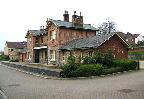
the architectural gems of today’s walk, the old London Road station building.
The former use of this H-shaped red brick structure, complete with canopy and
fragments of platform, is immediately evident, but it looks oddly isolated now
the rails that once surrounded it are long gone. Now Grade II-listed and thought to be the
oldest surviving GNR station building south of York, it houses offices and a
children’s nursery.
The route now runs under London Road and soon encounters another
splendid example of Victorian railway architecture, this time the work of the
Midland Railway: a towering but elegantly detailed brick arch bridge taking the
Midland Main Line over the competitor it was eventually to obliterate. Within
the arch are some murals depicting the history of the line. A little further, a
ramp into the 2010s residential development of Charrington Place provides a
direct route to City station, with more railway souvenirs on view at the
restored St Albans South Signal Box across the tracks, now operated by a local
trust with regular open days.
Just before the next road crossing at Camp Road, where a
2003 footbridge has replaced a sturdier structure, are the wooden remains of
a platform. This was originally a private halt for staff at Sanders Orchid
Nursery which was formerly adjacent. It came to be known as Salvation Army Halt
as it was also used by staff at the Salvation Army printworks, the Campfield
Press, which stood alongside the railway a little further on across Camp Road,
off Campfield Road, from 1889. Both businesses had their own sidings, and millions
of flowers and millions of bibles journeyed into the world this way.
Fleetville and Hill End
East of Camp Road, the city sprawled along the
railway from the late 19th century on, into the suburbs of Fleetville
to the north of the line and The Camp to the south. Various features can be
glimpsed through the trees, beginning with Hatfield Road Cemetery on the left,
the city’s first municipal cemetery, opened in 1884 and still in use today,
followed on the same side by the playing fields of Longacres open space.
On the
opposite side of the track here is a more poignant burial ground, filled with
the graves of inmates of Hill End mental hospital nearby. In the first half of
the 20th century, over 1,000 corpses were buried seven-deep here in
communal graves marked only with numbers, though in recent years volunteers
have tidied up the space and created more dignified memorials, renaming the
space, now a County Wildlife Site, the Hill End Garden of Rest.
Hill End Hospital is one of those big suburban asylums that so fascinates London psychogeographers like Iain Sinclair, Most of them were built following the Local Government Act 1888 which gave county councils a duty
to care for ‘lunatics’. The Hertfordshire County Asylum opened in 1899 just to the south of the railway line, on a self-sufficient
site with its own farm, railway siding and station. It was known as progressive
in its day, with outdoor activities and occupational therapy, but people with
mental disabilities were still treated alongside those with mental illness until
a dedicated unit for the former, Cell Barnes Hospital, opened on an adjacent
site to the south in 1933. On the outbreak of World War II, Hill End was
requisitioned as an emergency facility for both military and civilian casualties,
pioneering among other things reconstructive and plastic surgery. It returned
to use as a psychiatric hospital under the NHS in 1948, and was a target of the
evolving critique of mental health care in the 1960s and 1970s. You don’t have
to look far on the web to find horror stories from this period, particularly
from patients of its Adolescent Unit.
 |
| Platform remains at the former Hill End station on the Alban Way, St Albans |
With the move towards community care, the idea that mental
health patients should be segregated ‘out of sight and out of mind’ in places like this fell out of medical fashion. The hospital finally closed in 1996 and
the site was redeveloped as housing and parkland, now known as Highfield Park. Most of the buildings were
demolished but three blocks were converted to social housing and the former
chapel is now an arts centre. The old siding has been obliterated but the
former station platforms are clearly visible from the path. Spare a thought as
you pass for the thousands whose lives changed for better or worse here.
Once across Hill End Lane the Countryway re-enters WatlingChase Community Forest, although the views to the north soon become industrial,
a result of council policy to encourage businesses out of the centre into the
city’s own ‘east end’ since the late 1940s. But there’s now open country on the
opposite side, the site of Butterwick Farm prior to World War II, later used
for gravel extraction and still known as Smallford Pits even though it was
restored some years ago. One of the pits remains a little further along as a fishing
lake. Soon after this you’ll encounter the substantial platform remnants of
Smallford station, opened as Springfield in 1866 and renamed in 1879. The
former ticket office can also be seen in the builder’s yard nearby.
 |
| Overlooking the fishing lake at Smallford Pits from the Alban Way, just west of the former Smallford station |
Sleapshyde and Roestock
The route now finds its way between a couple of
other scattered settlements in the slice of Green Belt between St Albans and
Hatfield, all part of the parish of Colney Heath, relatively flat countryside
straddling the very upper reaches of the river Colne. Approaching the edge of
Sleapshyde across fields, there's a rare overt sign of the Community Forest as
the Countryway joins for a short time the Watling Chase Trail. When this was
first developed in the 1990s it was known as the Watling Chase Timberland Trail,
as footwear manufacturer Timberland sponsored trails in all the Community
Forests. The sponsorship has long ended but cannily the company had their
distinctive tree logo used as a waymarking device. The trail runs north to
south through the centre of the Forest area. We encounter it very near its
northern end, at Wilkins Green a couple of kilometres north of here and also on
the Alban Way; to the south it stretches to Elstree where it links with the
London Loop, giving the most direct link in some time between the Countryway
and the Loop.
 |
| Sleapshyde |
Sleapshyde has a tiny remant of a village green complete with sign, pump and surrounding rustic buildings, which doesn’t quite make up for the fact that its southern side is
lopped off by the A414 North Orbital Road. As its name suggests, the road,
formerly numbered A405, was originally envisaged as part of an orbital highway
route round London when it was first built in the 1930s by the Ministry of
Transport, one of many successive concentric circles drawn round the capital
over the decades by planners. Patrick Abercrombie's 1944 Greater London Plan chose
it as one section of the "E Ring", the outermost of five ring roads
which together with the Green Belt would help define that all important edge of
the capital. Interestingly Abercrombie didn't see the E Ring as primarily a
fast traffic route but as a "Parkway", including "a strip of
open space which gives it a positive amenity value...at once part of the
communications and part of the park system."
This grand plan was never implemented
due to lack of funds, but the London County Council, its successor the Greater
London Council, and the Ministry of (now the Department for) Transport continued
to draw up radical and sometimes conflicting plans for further circular and
orbital routes. In the 1960s, Abercrombie's E Ring re-emerged minus green strip
as Ringway 4, but this time public horror as well as underfunding and internal
politics scuppered the proposals. Instead we got the M25, and the old orbital
was renumbered A414 in an effort to discourage longer distance traffic. Even so
it remains a busy road which the Countryway is now obliged to cross via a very
minimally formal crossing point. As you dodge through dual lanes of fast cars
to zigzag around the gap in the crash barriers on the central strip, try to
imagine Abercrombie's positive amenity value.
There’s a very physical link between the flat area we’re
now crossing and the big roads that now entangle London, including the M25:
much of the gravel needed to construct them was dug from beneath the land we
now cross. These gravels were originally deposited by the Thames on its old
course and the glacier that diverted it to its new one, as described above. The
green space and woodland south of the A414 is another restored former gravel
working.
Beyond this is Roestock, a hamlet in the triangle of an
old road junction, and where its houses end along busy Tollgate Road, the
Countryway leaves St Albans district and enters the borough of Welwyn Hatfield.
The boundary, which appears to go right through the middle of a house, is a
relatively new one, dating from an extension to St Albans in 1913.
Welham Green
 |
| The A1(M) between Roestock and Welham Green, looking north. |
 |
| A strange figure peers from Bush Wood onto Dellsome Lane, Welham Green. |
The
village was originally a tiny hamlet on the northern edge of North Mymms but is
now really a southern extension of Hatfield, linked by light industrial sprawl.
It's a plain-looking place dominated by 20th century residential development. So
big has it become that its name has supplanted its historically more important
neighbour as the common label for the area. The substantial triangular junction
where Parsonage Lane and Huggins Lane converge on Dellsome Lane before the
village centre is known as Balloon Corner, as it was the site of the first
landing of the first passenger hydrogen balloon flown in England, piloted by
Vincenzo Londardi in 1784. Londardi had a dog, a cat and a pigeon with him when
he took off from Moorfields, London, but the cat got airsick, so he landed in
Welham Green and handed it into the care of the locals: an engraved plaque
marks the spot. The flight finally ended at Thundridge near Ware, off to the
northeast.
The original Countryway route headed for Brookmans Park
station rather than Welham Green but since then, not only has a path been
diverted inconveniently to avoid a stopped up railway crossing, but an entire
new station has opened much closer to the route. Both stations are on the Great
Northern Railway which opened from London to Peterborough in 1850 as the first
stage of a main line from Kings Cross to York, built under the direction of the
great civil engineer William Cubitt (not to be confused with the near
contemporary politician William Cubitt who built Cubitt Town on the Isle of
Dogs). The line ran from Potters Bar to Hatfield on an alignment roughly
parallel with but to the west of the Great North Road, originally with no
intermediate stops. Its successor the London and North Eastern Railway (LNER) added
the station at Brookmans Park in 1926, in response to suburban development, but
Welham Green only got its station in 1986 under the nationalised operator British
Rail.
 |
| Welham Green station |


