Showing posts with label Darent Valley Path. Show all posts

Sunday, 7 May 2017

London Loop alternative: Dartford Crossways - Crayford


Welcome to the Enchanted Woodland, actually a smallpox cemetery in disguise.

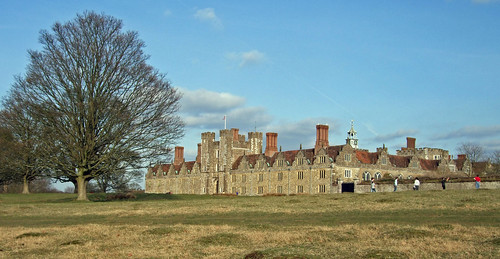
Completing my proposed alternative route of the London Loop using the public bus service across the Dartford Crossing, this is a moderately short and largely urban but pleasant and interesting walk linking the bus stop at Crossways in the suburbs of Dartford with Barnes Cray, back on the official route. Along the way, you can enjoy flooded gravel pits remodelled as landscape features of business parks, a closeup view of the Queen Elizabeth II bridge, and a visit to an enchanted woodland. The final stretch sticks to riversides through Dartford Marshes followed by an optional extension along the official trail to Crayford station.

There are plenty of opportunities to split the walk by bus, including the frequent FastTrack dedicated busway services linking Dartford, Bluewater and Gravesend, although these don’t accept TfL cards. And you’ll pass close to Dartford station which although outside London is now conveniently in TfL’s Zone 8.

Since the Crossways bus stop is a short walk from the south bank of the river Thames, another obvious way of completing this walk would be to use the riverside paths more-or-less throughout, upstream along the Thames to Crayford Ness then upstream along the Darent to Bob Dunn Way Bridge to meet the route described below. This is a very good walk, and a little more straightforward, but it’s 2 km longer. At some point I plan to explore the Thames Path and its actual and possible extensions in more detail in these pages, so for the time being I’ve found a more varied and surprising route inland. For more about the issues of completing the Loop in the east and why I’ve proposed this alternative as a bonus feature to the official trail, see my previous post.

Dartford, Kent


It’s appropriate that the geographical area where our circuits of London start is named after a rim or border. The word ‘Kent’ most likely derives from a Celtic term with this meaning, Latinised by Julius Caesar as Cantium. Its people, whom Caesar described as “by far the most civilised” of the Britons, were known to the Romans as the Cantiaci.

As the closest part of England to the European mainland, Kent will always be border country. But borders are rarely entirely impermeable, and the county has long been the conduit for people, cultures and ideas. Caesar himself first landed in Walmer near Deal from Boulogne in 55 BCE, and the ancestors of the Belgic and Celtic people he encountered had likely reached England via that same shoreline. The force that finally annexed most of Britain to the Roman Empire during Augustus’ reign in 43 likely landed at Richborough. Where their march northwest was interrupted by the Thames, they created a river crossing on the line of the later London Bridge, and inadvertently founded London.

Following the withdrawal of Roman rule in the 5th century, Jutes from what’s now southern Denmark migrated to East Kent and Saxons from western Germany followed them to West Kent. By 597, the year the Italian Christian priest Augustine landed at Reculver, Kent was a stable Anglo-Saxon kingdom, under Æthelberht, the first reliably attested king, some of whose laws survive as the oldest-known written English texts. Augustine completed his mission to convert the king, and became the first archbishop of Canterbury. The next and, so far, most recent successful occupation of Britain, by William of Normandy in 1066, was an exception, beginning in Sussex rather than Kent. The fact that William’s troops marched through Kent without formally demanding a surrender is the explanation for the county’s traditional motto, Invicta, meaning ‘undefeated’.

There’s still an echo of that old split between Saxons and Jutes in numerous institutional divisions between east and west Kent, and in the folk distinction between the demonyms ‘Man/maid of Kent’ for the east and ‘Kentish man/maid’ for the west, with the boundary almost but not quite following the river Medway. As these pages don’t look much beyond the immediate hinterland of Greater London, Jutes and men and maids of Kent are beyond our area of interest.

From Roman times, London itself has formed part of this rim country, the first big metropolis where the flow from the southeast eddied and often settled. So the city became the greatest borderland of all, flourishing as a multicultural, polyglot melting pot and a laboratory of new ideas. It’s long maintained a Kentish foothold, with a royal palace at Greenwich since before 1300, and a later royal dockyard at Deptford, both effectively extending the capital downstream along the Thames. When the county of London was belatedly created in 1889, it formally incorporated those parts of Kent roughly equivalent to today’s Greenwich and Lewisham boroughs. London returned for more in 1965, absorbing Bexley and Bromley.

And as everywhere, that borderline status of both London and Kent has remained problematic, its permeability both desired and resented. You’re forcibly reminded of the border if you’re unlucky enough to get caught up on the M20 approaching Folkestone during Operation Stack, the periodic clampdown on vehicle passage through the Channel Tunnel. Sadly, the current trend is hard rather than soft: in the referendum that sparked the current self-harming process of the UK leaving the European Union in June 2016, while almost 60% of Londoners voted to remain, 59% of Kent voted to leave.

Dartford takes its name from the ford on the river Darent around which the original town grew in Roman times. It’s the easternmost of three ‘Ford’ towns where the Roman highway later known as Watling Street, and highly likely its Celtic predecessor, crossed Thames tributaries. The others, from west to east, are Deptford, the ‘deep ford’ on the river Ravensbourne, and Crayford, on the river Cray – the destination of today’s walk. I’ve said more about Watling Street when discussing the London Countryway, which crosses it between Gravesend and Sole Street.

In the Roman period, Dartford could well have been an important local centre, given the attested presence of several apparently prosperous villas in the fertile Darent valley. The road later became a pilgrim route to Canterbury, as made famous by Geoffrey Chaucer, and Dartford, which could be reached from London in a day by an energetic walker, was an important stop on the way.

By the 14th century the town boasted two priories and a weekly market, and was likely one of the key rallying points for the rebels from Essex and Kent who marched on London in 1381 during the ill-fated Peasants’ Revolt. Alongside Deptford and Maidstone, it’s a claimant to the birthplace of revolt leader Wat Tyler, though there’s no proof of this. I’ll have more to say about this incident in a later post, likely on a walk visiting Blackheath, much closer to London along Watling Street.

Dartford industrialised comparatively early, thanks to a convergence of geographical factors including the river and road links to London, the abundance of good water which also provided power for mills and, like Purfleet and Thurrock across the Thames, the presence of chalk deposits close to the surface. The first paper mill in England opened here in 1588 and more soon followed. There were chalk pits in mediaeval times, and more recently pharmaceuticals figured highly among the local produce, as we’ll see. Among Dartford's more recent exports is Rolling Stone Mick Jagger, who has a local arts centre named after him.

By the mid-20th century, Dartford had effectively become a commuter suburb and continuous urban sprawl connected it to London in several places. It was one of the areas reviewed by the Royal Commission on Local Government in Greater London in the late 1950s for possible inclusion in an enlarged capital. But the Commission’s final report stopped short of recommending this, presumably because the town was still relatively self-contained: unlike some places outside London encountered on the Loop, it wasn’t excluded at a later stage following local protest.

In 1974, the Victorian-era Municipal Borough was enlarged with the inclusion of the rural hinterland to create the present Borough of Dartford. A more recent proposal to create a unitary authority by merging it with Gravesend was also rejected, so it remains part of the two-tier local government system of Kent. Unsurprisingly, though, the idea of Dartford becoming part of London is still regularly discussed, and local opinion appears almost equally divided on the issue.

Like many other places just outside London, Dartford is dominated by the capital without being able to enjoy the benefits of belonging to it. Local identity and viability have been placed under enormous pressure from industrial decline and retail competition from the West End and closer by. The giant Bluewater shpping mall just downriver, is widely blamed for turning the once-flourishing town centre into a denuded parade of closed shutters, charity and pound shops. But today’s walk avoids the historic centre in favour of its post-industrial hinterland, so we’ll need to wait for a later post to test this judgement.

Crossways

Former chalk pits at Crossways are now lakes enjoyed by local workers.

Observant walkers who have crossed the Dartford Crossing from the previous section will notice that the surroundings on both sides of the Thames here are telling essentially the same story. Both are the recently redeveloped sites of former chalk quarries.

Once across the river, the bus from Chafford Hundred stops at the Galleon Boulevard stop in the Crossways Business Park, right by a Campanile hotel set behind an attractive pond complete with a fountain. This area was once part of Stone, then the next parish downstream along the Thames from Dartford, and was known as Stone Marshes. As on the other side, the marshes were successfully drained in mediaeval times to create quality farmland. Then chalk was found in the late 1860s, and over the next few decades, fuelled by the demand for cement from the London building industry, no less than four quarries appeared, with associated cement works and other facilities, all linked by a private tramway. By the 1930s they had all been incorporated into one giant undertaking, the Dartford Portland Cement Works.

These works fell into progressive disuse after the war and were finally demolished in the 1970s, leaving a blasted landscape of pits and slag heaps. Regeneration began in 1988, with a big distribution depot for supermarket Asda soon opening on the riverside, and the former cement wharf next door becoming a freight shipping terminal. The 120-ha Crossways Business Park now houses over 50 businesses employing 5,000 people. Rather like Stockley Park on section 11 of the Loop, it just missed the change in planners’ thinking towards more mixed-use development, so it’s one of those places that feels oddly compartmentalised and lonely, although there are two hotels and a scattering of residential properties.

This may seem an unpromising environment to walk in but turns out to be more pleasant than expected, helped enormously by a network of off-road paths and numerous water features remodelled from chalk pits, like that Campanile pond. Soon, you’re walking beside another, rather larger example known as Cotton Lake. Until the late 19th century there was a farm here, Cotton Farm, later overwhelmed by the pit which forms the basis of today’s lake. North of the lake, an 1870s map shows watercress beds steadily being encroached by chalk workings.

Our route leads straight across the Littlebrook Interchange connecting Dartford and Crossways with the M25 and the Dartford Crossing. This was first opened as part of the initial construction of Crossways in 1988 and substantially enlarged in 1996. The main interest here is the view from the flyover end-on to the Queen Elizabeth II Bridge and down to the tunnel approaches. Try to imagine the scene in the 19th century when this was Littlebrook Farm: the only survivor from this era other than the name is the fragmented strip of woodland that surrounds the A282 to the southwest. There’s a lot more about the Dartford Crossing and the bridge in my previous post.

View from the Littlebrook Interchange: tunnel beneath, bridge below.

Joyce Green and Temple Hill


Repurposed fence posts in the Enchanted Woodland
The residential streets west of the interchange were built on farmland as social housing between 1951 and 1960 in response to the post-war housing crisis, and still comprise Dartford’s largest area of deprivation. The neighbourhood is known as Temple Hill, recalling the fact that this was once Temples Manor, gifted by Henry II to the Knights Templar in the 12th century. Temple Farm stood in the northwest corner until it was demolished to make way for housing during the original development.

The trail runs through another fragmentary strip of woodland surviving from Littlebrook Farm, before following streets named rather pompously after poets and authors: Wordsworth Way, Wodehouse Road, Chaucer Way. Another familiar name around here is Joyce Green, not after the experimental Irish novelist but another farm to the northwest, which still survives, unlike the hospital which borrowed the farm’s name in the 20th century.

Following the advance of epidemiology in the late 19th century, but before the perfection of effective vaccines and antibiotics, highly infectious diseases like smallpox, which spread rapidly in densely populated urban areas, were contained by isolating those already infected. In a grim echo of the prison hulks from the Napoleonic period, in 1881 two former Royal Navy wooden warships were pressed into service as offshore hospitals. At first, they were moored off Deptford but in 1883 were moved to Long Reach off Dartford where they were joined by a third vessel, a former cross-Channel paddle steamer.

But conditions on board were far from ideal for the purpose, and in 1901 the Metropolitan Asylums Board began work on a land-based isolation hospital at Joyce Green Farm, a little inland from the ships. Work had barely started when a new smallpox epidemic hit London, so two further hospitals were built originally on a temporary basis a little closer to the river, known as Long Reach and Orchard hospitals.

Joyce Green hospital opened with 940 beds in 1903, though the outbreak of the previous year turned out to be last major smallpox epidemic in London, so in 1910 the hospital was repurposed to handle fever cases. It remained largely empty for periods in the 1920s and 1930s before becoming a military hospital during World War II, at one point reserved for the Free Dutch Forces based in Britain. Later it was a general hospital, becoming part of the NHS in 1948. It finally closed in 2000, superseded by Darent Valley Hospital near Bluewater.

The site is currently undergoing redevelopment as a housing estate and science park known as the Bridge. The curious layout of the original hospital, so distinctive on contemporary maps with its 22 separate ward buildings arranged symmetrically in an echelon formation and originally connected by a horse-drawn tramway, has been completely obliterated by demolition.

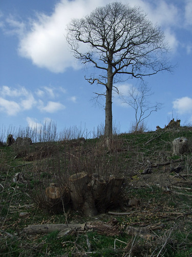
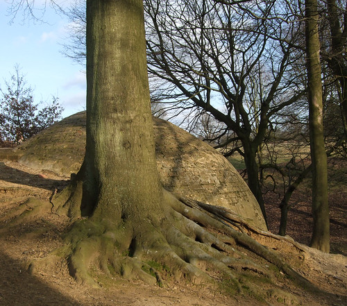
One curious corner of the hospital does survive, though in a rather different form. In the early 20th century there was no effective treatment for smallpox and the mortality rate was high, so a corner of the grounds to the southeast was consecrated as a cemetery. The site was last used for burials in 1951, and gradually became overgrown. By the 1960s it was surrounded by new houses, and it became known locally as an informal open space, especially after 1993 when it was severed from the hospital site by the construction of the new A206 road. But it also suffered major problems with litter and fly tipping.

Following the closure of the hospital, a local campaign pushed for the creation of a community woodland on the cemetery site. It was bought from the Department of Health for £1 in 2009 and reopened under the management of charity the Temple Hill Trust as the Enchanted Woodland, remarkably the only substantial area of public woodland in Dartford. With little funding available, the restoration and maintenance of the site, including the removal of over 20 t of illegally dumped rubbish in 2013, has largely been a volunteer-supported project. Since 2016 it’s been managed by a local school, the Temple Hill Primary Academy, and students have embarked on a new programme of planting using saplings nurtured in the surrounding house gardens.

Visiting the woodland requires a horseshoe-shaped deflection of the route but I’m sure you’ll agree it’s worthwhile. It’s a dappled patchwork of mature trees planted when the hospital was first developed, ivy-carpeted secondary woodland, more recent saplings and patches of grass. In spring, it’s noted for violets, likely descended from some that were once planted on a grave. Dotted throughout are more recent and often quirky decorations, like hand-carved signs, and an old fence line turned into a decorative feature, lending a distinctive and intimate feel.

Only one headstone remains, commemorating a nurse, Ethel Chapman, who died in 1922. This, and the overgrown yew trees, are among the few on-site clues to the site’s origins. So it’s astonishing to learn that 1,039 bodies are buried here, of which 802 are from a single year, victims of the last great London smallpox epidemic in 1902. According to the official history compiled by the Trust, at the peak of the epidemic a new communal grave was dug each day, and filled with up to 14 corpses in sacks stuffed with straw and charcoal to absorb the bodily fluids. Most graves were marked with a simple numbered metal spear, none of which still stand, though some are preserved by the Trust. There are two military burials from World War I but, unusually for war graves, even these are unmarked. After 1936, there were no more burials until the final five in 1951.

The walk then threads through grassy strips that formed part of the original estate design, and suddenly you find yourself atop a modest cliff. A wide view opens north towards the Queen Elizabeth II bridge and the Thames, with the low hills of Essex visible on the other side. The cliff appears on mid-19th century maps and is likely a relic of chalk diggings, although from an earlier period than the large scale works of the 1870s and after. Today, a flight of steps leads down it to a children’s playground nestling in its shadow, known as the Joyce Green Lane Recreation Ground.

Clifftop view north over Joyce Green Lane Recreation Ground and the marshes.

A gate from the playground leads onto Joyce Green Lane itself, once an old farm track from Temple Hill into the marshes, and later the route travelled by hospital patients from the station. Then another grass patch, Wellcome Avenue Open Space, bridges the transition to an area of rather different character. The clue is in the name, for Wellcome Avenue commemorates one of Dartford’s most significant industries.

Industrial Dartford


This birch on the corner of  the former Wellcome North Site
overhangs the route of a cement works tramway.
The marshy area to the north of Dartford town centre, with the tidal river Darent close at hand for water, power and transport, has been an industrial zone since at least the 16th century. Back then, a tidal-powered steel slitting mill stood on the riverside near the northern end of the High Street. Over the centuries this grew into the biggest milling complex on the river, known as the Phoenix Mill and used at various times for timber, cotton, flour, mustard, linseed oil and paper. This last commodity is something of a local speciality, produced in the area since at least 1588 until early in the 21st century.

In 1889, the mills were sold to pioneering pharmaceutical company Burroughs Wellcome & Co, founded by two US-born pharmacists, Silas Burroughs and Henry Wellcome. This originated in Wandsworth, on another Thames tributary we’ll be visiting on later walks, in 1880 but soon outgrew its original site. If you break your walk at Dartford Station, you’ll be able to see the mill pond, remodelled by Burroughs Wellcome into a decorative lake with artificial islands, providing a suitably attractive frontage for what was intended to be a model factory. The station opened when the South East Railway extended its North Kent Line west from Gravesend towards London in 1849, improving the connectivity of the mill site still further.

Burroughs Wellcome played a lead role in establishing the pill as a form of medication, and is further noted for the emphasis it placed on research: among other things it made major advances in the production of antihistamines, insulin and, more recently, the antiviral drugs used to manage HIV infection. Its philanthropically-inclined co-founder wanted the profits spent on improving human health, and after his death in 1936, his legacy was used to set up the Wellcome Trust, still a major funder of medical research, as well as the owner of one of London’s most fascinating museums at its Euston Road headquarters. But the original company has subsequently been absorbed through mergers, and is now part of the world’s sixth largest pharma multinational, GlaxoSmithKline (GSK).

At first Wellcome occupied only part of the mill complex, with some of it leased to a flour miller, but in the early years of the 20th century the drug company expanded to fill the rest, and then beyond. Immediately to the north, and to your left as you begin to walk south along Central Road, was one of the late 19th century cement works, connected to a wharf on the Darent by a tramway which crossed your path through what are currently the locked gates on the right a few steps further south: an interpretation board marks the spot. Another tramway ran north-south along Central Road to the mills. The cement plant was disused by World War I when it housed German prisoners of war before being occupied by Wellcome.

The area on the right (west) side of Central Road, known as the North Site, was farmland attached to Temple Farm until as late as the 1980s, when it too became an extension of the Wellcome plant. This use proved relatively short-lived: GSK closed the entire plant in 2011, laying off 650 staff – equal to half the 1,300 who had worked at the site in its peak years. Unsurprisingly given its proximity to the station, the whole lot is being redeveloped as housing. At the time of writing, building has only just started on the North Site, but 400 homes on the older site opposite are nearing completion. Pleasingly, the new neighbourhood will be known as the Phoenix Quarter, reviving the old name of the mill.

The land between the North Site and a former paper mill close to the station is occupied by a later 20th century development of light industrial units: not especially attractive or distinguished, but providing a straightforward walk along the obviously named Riverside Way to the Darent and the more open surroundings of the final stage of the walk.

Dartford Marshes and the Darent


Boardwalk alongside the river Darent by Riverside Way Industrial Estate, looking upstream at low tide.

The river which gives Dartford its name rises from the Greensand ridge at Crockhamhill Common, south of Westerham, close to Kent’s western boundary with Surrey and only a few hundred metres from the route of the London Countryway through Kent Hatch. The Darent skims the northwestern edge of Sevenoaks and runs through Otford, Shoreham, Eynsford and Dartford to join the Thames on the marshes at Crayford Ness, a distance of 34 km. It’s a chalk stream, one of several encountered on these walks, and the exceptional purity of its water is one of the reasons its valley is associated with the paper and pharmaceutical industries.

A 31-km signed walking trail, the Darent Valley Path, traces the river’s course. Although this runs entirely outside London, it’s entirely within the London Countryway and therefore within the scope of this project, so I’ll discuss the river in more detail alongside the trail when I get around to it. This route follows a short section of the northernmost part of Darent Valley Path between Riverside Way and Bob Dunn Way Bridge.

The Darent is tidal below Mill Pond Road near Dartford station, where there’s a now-derelict lock that gave access to Phoenix Mills. As is the custom with Thames tributaries in the London area, the tidal section is known as a creek, Dartford Creek. Quite large boats could once sail this far at high tide, and a right of navigation still exists, although silting has made boating difficult. The recently formed Dartford and Crayford Creek Restoration Trust is currently working to remedy this.

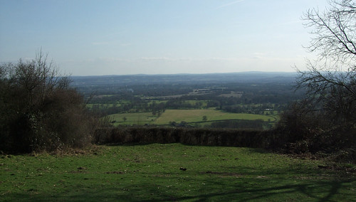
From Riverside Way a decent riverside path, augmented by a newish stretch of boardwalk, leads downstream into the marshes, soon leaving the industry behind. With Crayford and Erith Marshes (section 1 of the Loop) further up the Thames and Rainham Marshes (section 24) on the Essex side, Dartford Marshes forms the largest surviving remnant of an environment that once stretched much further upriver, and is now a designated Site of Nature Conservation Interest. Managed and drained since mediaeval times, the marshes were traditionally used for grazing, though also for activities that require isolation, such as explosive storage and testing and, as previously discussed, the treatment of infectious diseases. We’re far enough down the estuary here that the section closest to the Thames is salt marsh, though we won’t get that far today.

As I’ve said elsewhere, the marshes are a unique environment in the London area, both in terms of their wildlife value and their special and rather curious sense of remoteness. Yet they are undervalued and underappreciated. Fragmented ownership, split between ten different landowners on the Dartford side including the council and private interests, makes coherent management difficult, and paths and access points are limited. For the confident walker, this can provide a surprising sense of escape – sometimes you seem to have the whole marsh to yourself – but it provides insufficient surveillance to deter the likes of fly tippers and illegal off-road motorcyclists and partly explains the local reputation for antisocial behaviour. Don’t let this put you off – you’re unlikely to be troubled and can enjoy the space and the bird life on the muddy creek.

When I first walked these paths in the very early 1990s, there were no crossings of the Darent below Mill Pond Road, so the only possible riverside route north from there was all the way to the confluence and downstream along the Thames towards Gravesend. But in 1993 they opened the new A206 bypass, the road which severed the hospital site, originally known as University Way, but later renamed when the planned university failed to appear as Bob Dunn Way. Dunn, who died in 2003, was the Conservative MP for Dartford throughout the Thatcher and Major years, from 1979 until the ascent of Tony Blair’s New Labour in 1997.

This fast and busy road crosses the Darent just south of the mouth of the Cray, and pedestrian access from the riverside to the bridge has thankfully been provided, so although the traffic is something of an intrusion, there’s at least the opportunity to nip across the river.

Looking towards Dartford Salt Marshes from just north of the Bob Dunn Way Bridge.

From here you follow the river wall around the triangle of marsh between the Darent and its lowest tributary the Cray, soon turning to walk upstream along the latter as you’ll continue to do for the rest of this section. This stretch of river is also tidal and therefore known as Crayford Creek. It forms the boundary between Kent and Greater London here and the official route of the London Loop from Erith lies within hailing distance, along the corresponding path on the other side. Nearing the industrial buildings of Barnes Cray, you cross a footbridge over a minor tributary, the Stanham River, or rather a straightened arm of it that was once served the industries in Crayford like the Vickers works.

Crossing the footbridge, you leave Kent and enter the London Borough of Bexley, but there’s still a good path following the river as it bends past the waste reception centre and under the 1849 brick rail viaduct that also provides a distinctive feature on the official Loop route nearby. On the opposite bank, a bicycle is hoisted improbably on a tall pole above a ramshackle collection of huts and old containers: perhaps a trophy captured by the locals on nearby National Cycle Network Route 1 and displayed here pour encourager les autres. The Cray’s appearance changes dramatically here: you can see how it’s been straightened, widened and culverted, with boat docks and a turning bay. This work was largely carried out in 1840 to improve access to the mills on the site.

Did the locals seize this bike from a hapless cyclist on NCN1? River Cray, Branes Cray.

And so our walk reaches Thames Road at Barnes Cray where it finally meets the official London Loop as well as the more local Cray Riverway trail. There are buses from here, but I’d recommend continuing at least a little further into Crayford, enjoying the river’s further change of character into a more rustic and verdant stream, as well as the satisfaction of having actually completed a circuit around London, even if a short part of it had to be by bus.

Thursday, 27 August 2015

London Loop 1: Erith - Bexley

Crayford Saltings, where the remains of a Bronze Age forest are still visible at low tide.


THE LONDON LOOP STARTS OUT as it means to continue, with a remarkable and unexpected succession of contrasting environments. The flat, lonely expanse of the eastern marshes, demarcated by tidal rivers, is a habitat now rare in London and surprisingly remote. Then there are more intimate riverside surroundings, forgotten industrial heritage, a partly Tudor stately home with astonishing formal gardens, an ancient woodland and a village with a weatherboarded mill. This is an easygoing section sticking almost entirely to flat flood plains, and a fine encouragement to continue.

Update November 2017. Though I'd recommend first-time Loop walkers follow the official route described here first, there are a couple of alternative options for this section. First, for those who are determined to connect the detached ends of the Loop by crossing the river Thames in the East using the bus across the Dartford Crossing, your journey on the south bank of the river will start at Dartford Crossways and join the official route at Barnes Cray. More about the Dartford Crossing alternative. Second, an alternative section of the Cray Riverway provides a more direct route from Hall Place to Bexley, also connecting with the Shuttle Riverway towards Eltham. More about the Cray Riverway.
Erith station, start of the London Loop

Erith


The first thing to learn about the London Loop is that it’s not actually a loop. With no way for walkers to cross the Thames between the Woolwich foot tunnel and the Tilbury ferry, the trail is more like a giant letter C with its ends almost but not quite touching, kept tantalisingly apart by the broadening river. As such, it has a beginning and end, at Erith and Purfleet respectively. The two stations are 4 km apart as the crow flies, 240 km the long way round.

There were reasons for choosing Erith as the start point. It’s the closest significant riverside centre to the London boundary in the east on the London side and an extremity of two existing walking trails that predated the Loop: the Cray Riverway and the Green Chain Walk. And historically there was a cross-river connection here in the form of a ferry to Rainham. Doubtless the devisers of the Loop hoped this might one day be reinstated, a hope which now looks more realistic than it once did.

But it’s fair to say many walkers, myself included, would have found little reason to visit Erith if it wasn’t for the trails. Though the river is always compelling and there are a few intriguing fragments of waterside heritage left in the town, today it’s difficult to escape the impression of a neglected backwater of the Borough of Bexley, a dead-end for the displaced white working class of southeast London, inflicted with over-engineered roads and bland postwar architecture.

It’s actually improved a bit since I first visited in the 1980s, exploring the Green Chain Walk: traffic is better-managed, public art has been installed, river frontage opened up. The ghastly 1960s wind tunnel shopping precinct received a facelift in 2005, which has made it more hospitable but even more devoid of a sense of place. The other retail attraction is the massive supermarket opened in 1998 by Morrisons, then primarily a Northern-based chain, as its first outlet in the south of England.

It wasn’t always so. In the 1840s, a pleasure garden, arboretum and hotel lured Londoners onto pleasure steamers down the Thames. That same decade, in 1848, the station on the North Kent line opened, prompting local landowners to build country houses aimed at upmarket commuters on former farmland. It was then the town began to grow to its current size, but its history goes back much further. There are prehistoric traces and evidence of a Saxon settlement – the name likely derives from Old English and means ‘muddy harbour’. Likely the old village centre clustered further west and upriver, off our route and around St John’s church, before the station and the landing stage shifted the centre of gravity east

The church is likely a Saxon foundation with 13th century fabric, though a victim of excessively zealous Victorian restoration and now partly severed from its old hinterland by the railway and the parallel concrete scar of dual carriageway. In Henry VIII’s time a naval dockyard was established on the riverfront, complementing similar facilities upriver at Deptford and Woolwich: the king’s great vanity project Henri Grace à Dieu or The Great Harry, the biggest warship in Europe, was fitted out here in 1515.

A more noteworthy seafarer was Scottish sailor and privateer Alexander Selkirk (1676-1721), the original model for Daniel Defoe’s Robinson Crusoe, who landed in Erith in 1711 following his rescue from Más a Tierra, an uninhabited island off the coast of Chile, after a four-year stay, Industry expanded in the second half of the 20th century, with cable and armaments companies linked to the Royal Arsenal at Woolwich, and an influx of workers bestowing a more proletarian atmosphere. The devastation of World War II bombing cleared the way for the obliteration of most of the rest of the historic fabric by 1960s developers.

The Loop starts from the station, still with its rustic-looking Victorian building, and heads to Riverside Gardens. A few paces off the route along Walnut Tree Road is a fine Grade II-listed example of a red brick Carnegie library from 1906, its cupola surmounted by a bronze weathervane, in the form, appropriately, of a sailing ship. This lovely building, originally gifted alongside over 2,500 others across the world by Scottish-American philanthropist Andrew Carnegie for the benefit of the local community, once also housed the modest but engrossing Erith Museum. Scandalously, the building fell victim to council cuts in 2009, and though the library has since been rehoused in a new facility in the town centre, the museum seems to have gone for good.

The gardens occupy the site of the Tudor dockyard, which at the height of late 19th century industry housed a massive flour mill. It’s been a public amenity since 1937, though was remodelled and extended in 1982. The colourful plantings are welcome, though the layout, in a raised rectangle, seems sterile and enclosed rather than pleasingly intimate. But the site has a commanding view of the river Thames, with the salty reek of mud at low tide.

Site of the Pilgrim Ferry at Erith:
The London Loop's missing link.
Upriver is the sweep of Erith Marshes that once formed part of the Arsenal site, and beyond it the piers of the Woolwich Free Ferry. Downriver the banks diverge perceptibly, with the spindly arc of the Dartford Crossing bridge in the distance. Opposite, so near and yet so far, is Veolia’s massive landfill site on Coldharbour Point: you’ll find yourself walking along this northern waterfront and on past the RSPB’s Rainham Marshes nature reserve in almost 250 km’s time.

From here the Loop sets off along the Thames for a while, sharing its path with National Cycle Network (NCN) Route 1 (the Thames Cycle Route) and the Thames Path extension, the latter signed with a Thames barge logo. This isn’t officially part of the Thames Path National Trail, which ends at the Thames Barrier in Charlton, but an extension created by Greenwich and Bexley boroughs in 2001. In future I plan on writing more fully about the Thames Path and the river it follows, so for the moment just enjoy the waterside scenes.

The official trail runs through the gardens but I’d recommend you use the riverside promenade beneath, known as the William Cory Promenade for reasons which will become clear. You’ll not only be closer to the water but see the mural commemorating Henri Grace à Dieu and pass the jetty on the site of the southern terminal of the Pilgrim Ferry, so-called as it was once used by pilgrims from Essex heading for Canterbury.

When the mayors of Bexley and Havering unveiled the plaque here and its counterpart on the opposite bank in 1999 to mark the 800th anniversary of this once-strategic link, I doubt they seriously thought there was a realistic chance of it being restored: after all, London had done without it since the 1850s.

But today, as planners puzzle about how to improve connectivity between the two sides of the ‘Thames Gateway’ development area, once-idealistic proposals are starting to make more sense. What if: projects, an ambitious architectural consultancy which is also promoting a London version of New York City’s High Line rail viaduct linear park, is gathering support for the idea online, specifically citing the objective of ‘closing the Loop’. One easy way of achieving this would be to extend the existing Thames Clippers riverbus service from Woolwich to call at both Rainham and Erith.

You’re forced away from the riverside temporarily along Erith High Street, passing some of the town’s few older buildings: an early 20th century police station, a pair of cottages from the 1790s and a recently lost late Victorian pub, the Cross Keys, now residential but recognisable from its engraved glass. The Erith Playhouse, meanwhile, is older than it looks: the 1973 frontage conceals a stage and auditorium that began life as a cinema in 1913. It was first converted to a theatre by an amateur dramatic group in 1947 and remains a non-professional venue run by volunteers.

Erith Deep Water Wharf, the longest pier in London.
The stretch of riverfront beyond this was industrial until the late 1990s, when the Morrisons redevelopment opened up new access, including to the Loop’s first star attractions, the Deep Water Wharf. At around 360 m, this is the longest pier in London, reaching far enough into the river to defy the tide before right-angling to parallel the bank. It originated as the pleasure steamer terminal in 1842, and was later converted to industrial use: it’s still sometimes known as Cory’s Wharf after the company that long used it for coal distribution. Cory’s was likely founded in 1605 by woodmonger William Cory and still operates other sites along the river today, but is now a waste recycling business.

The current concrete structure, now simply a public amenity, dates from a 1957 rebuild: the rustic wooden hut at the shore end houses a substantial gate for use when floods are threatened. The late walking writer and campaigner David Sharp, who wrote the first guide to the Loop, suggested that when standing on the end of the pier it’s possible to imagine you’re on a boat at sea, even at low tide, and I strongly recommend you test his theory at least once.

Multiple signing on Erith Manor Road near the Yacht Club.
The promenade ends all too briefly with a deflection along busy Manor Road, avoiding a stretch where the riverside is still industrial. Recycling facilities predominate: this is one of the places where those big yellow barges often seen being towed along the river are heading. It isn’t the most pleasant section of the Loop, but the pavements are broad, and walkers do better than cyclists on NCN 1, who are compelled to swap from one side of the road to the other several times. And it soon ends at a sign pointing back towards the Thames along the drive of Erith Yacht Club, returning us to the use of the river as a place to play which helped put the town on the London map.

The signing has long gone, but this was the original official start point of the aforementioned Cray Riverway, first established by Bexley council in the late 1980s under the inspiration of the Green Chain Walk. Though partly superseded by the Loop, the trail is still modestly promoted, and we’ll stumble across some dedicated signing further along.

Crayford Marshes

Darent Industrial Estate
From the yacht club drive a dead straight track on a raised flood embankment heads out into the wide, flat landscape of Crayford Marshes. It’s a sight that always fills me with the anticipation of a satisfyingly brisk stroll through some of the most unique and unexpected surroundings London has to offer. Maybe it’s my Dutch ancestry because there are plenty of people who disagree with me: I’ve read several write-ups of the Loop that carp sourly about the ugliness of this stretch. I think it’s a question of expectations: if you set out on the Loop expecting pretty rolling English countryside, this is certainly not what you get, at least not yet.

But the marshes are near-unique – only Rainham Marshes on the opposite side and the closing section of the Loop are comparable in London. The surroundings are historic and rich in wildlife, an invaluable part of the Green Belt and an Area of Metropolitan Importance for Nature Conservation. Even the Darent Industrial Park nudging the river at Crayford Ness, with its mangled car wrecks and disintegrating shipping containers, adds to the atmosphere, contrasting with the wide open water, the windblown reeds, and seagulls swooping towards the always-visible arc of the Dartford Crossing. Approached with an open mind, the marshes have a desolate beauty and an unexpected sense of isolation that brings a genuine resonance to the phrase ‘urban fringe’.

Besides, the marshes are more honest to the ‘natural’ state of the tidal Thames. In Roman times these dank wetlands extended all the way up into central London, covering much of the flat land bounding the river including Lambeth and Southwark. Try picturing the Elephant and Castle in the middle of a scene like this.

In the 13th century, the land was drained and reclaimed for grazing by the monks of Lesnes Abbey, the ruins of which still overlook Thamesmead further upriver and on the Green Chain Walk. While most of the flood plain closer to central London was later built-up, this far-flung corner was remote enough largely to survive as rough grazing land into the 20th century, alongside other uses that required open, uninhabited sites, like the munitions factory that once stood on the industrial park site, and a World War II anti-aircraft battery to the west.

Depending on the tide, you can expect to look back even further in time. The 1 km stretch of foreshore known as the Saltings between the yacht club and Crayford Ness contains the remains of a forest dating from the Bronze Age which once stood on a now-inundated ait and is still visible at low tide. Archaeological investigations here have unearthed numerous fragments of pottery and flint tools.

The Thames Path Extension finally peters out at Crayford Ness where the river Darent joins the Thames as tidal Dartford Creek. This tributary rises on the Greensand ridge just south of Westerham and not far from Sevenoaks, and runs roughly north, largely as a chalk stream, for 34 km via Shoreham, Eynsford, Farningham and Dartford (‘Darent-ford’). The creek once formed part of an important transport connection to sites a little further along the Loop, and rights of navigation still exist, though in practice it’s been disused for this purpose since 1986 and has begun to silt up. There’s a local campaign to clear it again in the hope of promoting leisure use.

The Darent is a source of frustration to walkers and cyclists attempting to follow the Thames. While there are good rights of way along the flood defences on the other side, even more tantalisingly close than the other end of the Loop at Rainham, there is currently no way of crossing at this point, forcing a detour of over 10 km. This was one of the obstructions that influenced the decision to stop the Thames Path national trail at Charlton, and it was identified in a 2008 review of opportunities for extending the route as a major barrier to increased use of the riverside paths. A substantial new bridge in this far corner of London might once have seemed a remote prospect but again the Thames Gateway development plans now make it more likely.

Darent Flood Barrier
Even more frustrating is the fact there is already a structure straddling the Darent here, which has been looming ever larger in the field of vision for some time. This is the Environment Agency’s Darent Flood Barrier, built in 1982, and equipped with two 160 t drop-leaf gates that can be lowered to block off the waterway. But while there’s a gantry allowing engineers to cross from bank to bank, it’s unsuitable for public use. The barrier is so tall to avoid obstructing navigation, and any new bridge would have to match its 12 m clearance.

London Loop walkers have no need of frustration, however, as our way is in any case southwest along the Darent. Once past the industrial estate, the surroundings become increasingly green and open, with rough fields still used for their ancient purpose of grazing – though today largely by horses – on both sides of the deeply incised, muddy and reed-fringed creek, subdivided by brambly hedgerows and dotted with patches of scrub.

You’re right on the edge of London in another sense here, as since 1965 the Darent has formed the boundary between the London Borough of Bexley and Dartford borough in the county of Kent (before Greater London was created, the whole of Bexley borough was in Kent). You’re within hailing distance of walkers on the riverside footpath on the Kent side, part of the Darent Valley Path tracing the river to its source. For a general introduction to Kent, see the London Loop alternative route from Dartford Crossways to Crayford.

An old lane, Moat Lane, provides a break point with a link to the station at Slade Green, the easternmost settlement in London south of the Thames. If you head this way, a little north of the station, surrounded by a private field but visible from a footpath, you’ll find the remains of Howbury moated manor, now a scheduled ancient monument, and a 17th century tithe barn, which once stood on the southwest corner of the marsh. The main route, meanwhile, soon reaches the confluence of the Darent’s lowest tributary the Cray, where the trail is once more forced west, away from the Darent and further into London.

Confluence of the rivers Darent (running from right to left) and Cray (on the right) in Crayford Marshes, with Dartford Marshes in Kent on the opposite bank.

Barnes Cray


The Loop completes its journey across the marshes along a rather undistinguished lane through an industrial estate that is at least improved since I first walked it in the 1990s, when you had to dodge the mud thrown up by lorries on an unsurfaced track. To get those lorries through, they’ve had to dig out the carriageway underneath the low 1849 bridge that carries the North Kent Line, part of the same route that serves Erith.

You arrive at a roundabout on busy Thames Road, a far more desolate place than the marsh despite the surrounding buildings. It’s a non-place, like a chute down which vehicles tumble out of London. There used to be a run-down pub here, the Jolly Farmers, with a seafood stall in the car park but even that is gone. Yet although this side of the road is industrial, there are swathes of housing opposite, including new developments. A fenced meadow beside the river where locals walk their dogs, called the Jolly Farmers Recreation Ground after the lost pub, now seems the only amenity left.

The 14 km river Cray, which rises in a meadow in Orpington, is one of those rivers that has for some reason appended its name to many of the settlements on its banks. This is Barnes Cray, the lowest such example, which also bears the name of a prominent local family that owned a manor house on the riverbank nearby. The industrial area is known locally as the Sawmills although originally a Tudor iron mill stood on the site; a sawmill replaced it in 1765 and by 1819 had itself been replaced by a flour mill.

For centuries these installations relied on the Cray, then a much more vigorous river, for access as well as power, as narrow Iron Mill Lane, which ran through open ground from Crayford, was often impassable in winter. This changed when Thames Road opened in 1927 as the result of a government road building programming designed partly to provide employment. But water transport remained important for long afterwards: in 1977 around 400 t of grain a week arrived along the Darent and Cray. Today, like so much round here, the area is largely dedicated to recycling and landfill.

River Cray at Barnes Cray.
The Loop finally crosses the Cray and rejoins its banks by a carved wooden Cray Riverway post. The Thames Cycleway leaves our route here to follow the road; if you wanted to return to the Thames-side footpath, you’d need to head north again on the other side of the Cray back to the confluence, skip across the Darent on a road bridge and walk all the way back on its east bank to the Thames.

The surroundings that follow provide a striking contrast not only to Thames Road but to the previous stretches of waterside. The muddy tidal creek through open marshes has become a more intimate and more classically attractive stream enclosed by verdant banks with alders and willows. But only a constant battle against invasive giant hogweed preserves this sylvan scene. Barnes Cray Road, along which the trail temporarily diverts away from the river, once led to the manor house, Barnes Cray House.

This was demolished in the early 20th century to make way for the housing of Crayford Garden Suburb, built between 1914-16 as a model village to house workers at the massive Vickers factory on the other side of the river. David Sharp observes that the houses seem to turn their backs on the water. It seems unthinkable today, but there was a time when even good quality developments like the Garden Suburb failed to take advantage of pre-existing natural features.

Crayford


Waterside Gardens, the little park that now provides a focal point for Crayford’s town centre, presents a peaceful scene, but this has long been a town bustling with both transport and industry. It stands on Watling Street, once part of the Roman Iter II linking the north of England via St Albans and London to the Kent ports and thence to Rome. The derivation of the placename is obvious: this is where the road forded the Cray.

The road was a trackway long before the Romans arrived, and evidence of an Iron Age settlement from around 30-40 BCE has been discovered nearby. The site is likely the ‘Crecganford’ recorded in the Anglo Saxon Chronicles where Hengist, leader of the Jutes, defeated the Britons in 457 after the Romans had deserted them. A church stood here when the settlement was recorded in the 1086 Domesday survey as Erhede, and the oldest parts of the present building date from 1100. It’s dedicated to St Paulinus, a saint once popular among pilgrims making their way between London and Canterbury along Watling Street.

The good road connections and the river’s water and power attracted industry, not just to Barnes Cray nearby but to the town itself. By the 1670s there were tanneries and linen bleachers, and by the early 18th century Crayford was known for its fabric printers. The last of these, David Evans Ltd, which closed as recently as 2001, was also the last business of this kind in London, and renowned for printing fine silks for clients like Liberty and Christian Dior.

The traditional local armaments industry was strengthened when the Maxim company began making machine guns here in 1888. Later Sheffield-based combine, Vickers, bought it out and built a giant plant, which at various times made petrol pumps, calculators, sewing machines, machine tools, cars and aircraft as well as guns. The Vickers Vimy which John Alcock and Arthur Brown flew on the first non-stop transatlantic flight in 1919 was most likely made here. But with the ending of Ministry of Defence work in the early 1970s the vast factory fell into disuse and was eventually demolished in 1998 to make way for a retail park.

Waterside Gardens, generously refurbished in 2009, repays a closer look. Not only is it a beautifully designed and landscaped small park, but it incorporates numerous references to the town’s past: look out for both the Liberty Paisley pattern and reminders of Maxim and Vickers used in some of the structures and paving. Something similar has been done for another smaller park, Tannery Gardens, across the road.

Stand facing the busy main road junction with your back to the park and the river under your feet and you’re pretty much on the site of the original ford. Watling Street ran from left to right here. In 1718 the road was turnpiked and in 1840 diverted along the newly built London Road, the road immediately ahead of you, to avoid the steep hill past the church on the right. The Vickers site is off-route to your left, on the left side of Crayford Road.

Nearby is a municipal clock tower which conceals a sewer vent, built in 1902 when the area was part of Dartford Rural District. This is also the way to another break point at the station, originally opened in 1866 on the Dartford Loop Line, constructed by the South Eastern Railway to relieve the North Kent Line. The current building is modern, but the footbridge dates from 1926.

Update May 2017: if you're joining or leaving the Loop at Crayford, there's a new route through the redeveloped Town Hall Square, with some interesting public art on show. For a few more details see my blog on the Cray Riverway.

The long, low red brick building on the corner as you turn into Bourne Road is a remnant of the David Evans works: unexpectedly, it was originally a cowshed, as cow dung was once used as an ingredient of the dyes. When the marshland adjoining this site was being redeveloped in the 1850s, workers unearthed a Roman galley, which rapidly collapsed.

And Crayford has one further quirky treat in store. Just before turning into Hall Place Park, look for the elaborate and colourfully painted lamp standards outside the Bourne Road Garage. Made in Glasgow, these are all that remains of the luxurious 1,000-seater Princess Theatre, built at Vickers’ expense for local workers in 1916 near what’s now Waterside Gardens. The garage owners rescued them when the theatre, by then a cinema, was demolished in 1960 and moved them here. They’re now Grade II listed, and happily well looked-after, a cheerful splash of exotic colour from the profits on instruments of destruction.

Hall Place


Well-off merchant and former Lord Mayor of London John Champneys (1495-1556) built Hall Place on the banks of the Cray between Bexley and Crayford as his country retreat in 1537, amid extensive gardens and grounds. Later owners included Francis Dashwood (1708-81) of Hellfire Club notoriety, whose most significant architectural legacy is at West Wycombe on the London Countryway. His descendants rented it out as both a private home and a boarding school, but it was sold in 1926 and acquired by Bexley council, then still in Kent, in 1935.

Hall Place, Bexley: A house of two halves.
The house served as a US Army communications base in World War II, from where signals were intercepted for decoding at Bletchley Park, but after this the council seemed uncertain what to do with it. Much of the surrounding land – a vast 65 ha site on both sides of Bourne Road and stretching down to the railway – became featureless football and cricket pitches, while the house served first as a girl’s school then as council offices. The council turned down an offer from its counterpart in Dartford to turn the place into a college in the mid-1960s, because, as a newly created London borough, it wanted to break its links with Kent.

Finally in 2000 the house, gardens and western section of the park were leased to an independent charity, the Bexley Heritage Trust, which also manages another historic council-owned property, Danson House, not far away. The Trust has done wonders, with the help of a £2 million grant from the Heritage Lottery Fund, restoring the house and opening it up to visitors, improving the gardens and building a riverside café, visitor centre and art gallery. The result is one of the London Loop’s many gems.

The playing fields are still largely a dull expanse of grass, much appreciated by weekend footballers but less interesting for wildlife and walkers. Things improve when the trail returns to the riverside, which has been allowed to grow back into a more natural state. Reaching the big 2006 sports pavilion, the trail crosses the Cray again and heads through more playing fields towards the railway, but you’d be daft not to make a modest detour to the house and gardens.

This is also the route taken by another branch of the Cray Riverway, which as originally devised had both a northwestern and a southeastern option for navigating the lack of riverside accesss between here and Foots Cray Meadows. The London Loop hedges its bets by following first one branch, then the other. The northwestern alternative links to another Bexley council trail, the Shuttle Riverway, which follows Cray tributary the Shuttle upstream towards Eltham and the Green Chain Walk.

One curiosity of the house itself is that it’s so obviously in two halves. Champneys’ original building is unmistakably Tudor, arranged around a great hall, with walls in a delightful checkerboard of flint and rubble – some of it recycled from the ruins of Lesnes Abbey, a real sign of the times as secular wealth supplanted monastic power and influence. In 1649 a new owner, Robert Austen, near-doubled the size of the house but in a completely different red brick style, adding an intimate and elegant courtyard under a staircase tower as well as elaborate plasterwork in the interior. It’s the sort of thing that would never get planning permission today, but the effect is charming.

The most famous garden feature is a striking array of topiary depicting heraldic figures: this was begun in the 1920s by then-tenant, society hostess Lady Limerick, and completed in the 1950s to mark the coronation of Elizabeth II: ten figures known as the Queen’s Beasts are based on plaster statues sculpted for the coronation, replicas of which are displayed at the Royal Botanic Gardens, Kew. Arguably even more beautiful and intriguing are the lavish plantings in the walled garden which now gives access to the house, including a series of ‘model gardens’ intended to demonstrate what can be achieved in a limited urban space.

Alongside the A2 at Bexley.
Back on the Loop, you’ll find yourself zigzagging to navigate the Dartford Loop railway and the trail’s first trunk road. Crossing the railway, the trail runs briefly right alongside the A2 East Rochester Way, the successor to Watling Street, first built in the early 1920s and much expanded in the early 1970s. Only a crash barrier separates walkers from three lanes of traffic with a much-ignored 50 mph speed limit. Then the path angles back on itself to follow the railway under the road.

Over the Loop’s first stile, the trail runs alongside the old woodbank of its first ancient woodland, Churchfield Wood, a remaining 2 km-long strip of what was once a much bigger wooded area. Trees include the rare field maple, and there are fine bluebell displays in spring. Your legs will tell you that at last you’re climbing modestly above the flat floodplain here, though not for long as the route soon descends again towards Bexley itself.

Old Bexley

Old Mill, Bexley: actually a contemporary pastiche.
It’s a cliché to talk about London ‘villages’, but one with some justification, for many of the city’s neighbourhood centres were originally independent villages, and sometimes substantial towns, that were later overwhelmed by sprawl. Few of these villages look quite as villagey as Bexley, or Old Bexley as it’s usually known, to distinguish it from both the wider borough and Bexleyheath, on the higher ground along Watling Street to the north, which later became the area’s major centre.

Bexley, likely meaning a clearing with box trees, stands where the ancient track between Eltham and Dartford crossed a path along the valley from Crayford to Orpington by a ford on the river Cray. It was established by 815 as a Saxon village held by Christ Church, Canterbury, with a church dedicated to St Mary the Virgin, and is recorded in the Domesday survey as having three mills.

The village expanded significantly in the Victorian period, particularly with the arrival of the railway in 1866, but miraculously maintained much of its character and original layout and is now a conservation area. The railway line divides the scene into a more rural southern part and a bustling Victorian village street, albeit now rather blighted by traffic.

Bexley is where the Loop switches between the northwestern and southeastern variants of the Cray Riverway via the village itself. The latter heads off up the ridge above the river, passing the Woodland Trust’s Joydens Wood with its prehistoric earthworks, but that’s an adventure for another day. A small Victorian cemetery by the path junction, originally created as overspill from the churchyard, is now managed as a nature reserve.

Then there’s the church itself, dating from the end of the 12th century but much extended in the 13th and ‘restored’ in 1883: the curious spire with an octagonal cone apparently balanced atop a four-sided pyramid has an almost comical effect. Tucked away behind the church is a 16th century manor house, and High Street House just along from the church is the former home of historian John Thorpe (1715-92), whose note of a Roman pavement at Lullingstone in the Darent valley to the east led to the later uncovering of a complete Roman villa on the site.

The Loop crosses the Cray again at the site of the old ford. Straddling the river here is a weatherboarded millhouse, actually a late 20th century pastiche on the site of one of the Domesday mills. It replaces a similarly-styled 1779 flour mill which burned down in 1966. Even though it’s a fake it’s still a striking building, speaking to history, the regional building styles of rural Kent and the way natural features and the needs of industry shaped our built environment.

Bexley station.
Beyond the railway bridge, along the sinuous high street, are numerous buildings from the 18th century or earlier: the Kings Head pub has 16th and 17th century elements, and the 1884 Freemantle Hall has some attractive terracotta detailing. Dominating the view is the spire of St John’s church at the far end of the High Street, built in 1878 as a chapel of St Mary’s to serve the swelling population. The bulky building at no 34, on the corner of Station Approach, is an old workhouse, built in 1787, which now houses shops.

The first section of the Loop concludes at Bexley station, conveniently set just behind the High Street, its substantial forecourt originally designed to allow horse-drawn carriages to turn easily. Like Crayford this opened with the Dartford Loop line in 1866; unlike Crayford, it still retains its original rustic-looking clapboard building. It’s a good place to reflect on the variety of this first section of the Loop, and there’s much more to come.

Thursday, 26 March 2009

London Countryway 19a: Borough Green - Sevenoaks

knolehouse

If the North Downs are the wall around the south of London, then the Greensand Ridge is its advanced line of defence. This largely tree-topped ridge of greenish-coloured 'lower greensand' sandstone runs roughly parallel to the Downs and a few kilometres to the south. It's part of the geography of the Weald dome rather than the London basin, though of course the geological structures are continuous. The greensand dates from the Aptian stage of the early Cretaceous period, some 125-112 million years ago, and, like chalk, is associated with life and seas rich in organic deposits. The chalk came later, a vast continuous sheet of it, and north of here it became indented to form the London basin, while south of London earth movements ab0ut 30 million years ago pushed layers of chalk and greensand up into a dome. Erosion did the rest, slicing through the chalk at the top of the dome to expose the underlying rock layers, leaving exposed chalk as ridges round the edge -- today's North Downs and South Downs -- with the greensand layer below the chalk now also exposed as a second ridge.

That ridge marks the furthest edge to which the London Countryway ventures, and it dominates today's walk, much of which is through what the Kent Downs Area of Outstanding Natural Beauty identifies as the "Sevenoaks Greensand Ridge". According to the AONB. its key landscape characteristics are "extensive mixed woodlands, heathy commons, small orchards and pastures, magnificent views, lines of mature trees, ragstone buildings", all of which I'll see today. The magnificent views are southwards towards the High Weald, part of which also forms a separate AONB, where more hills, of earlier Wealden sands, push up from the broken centre of the dome. Last week, leaving the Downs, I started to feel I was straying too far, with the gravitational pull of London weakening. Today, I'm reassured that we've reached the outer limit of this part of our journey -- Keith Chesterton, who devised the route, keeps it clinging to the ridge, gazing at but not venturing into the Weald proper, and I'll end today's walk in a major commuter town.

Also characterising today's walk is a series of historic buildings and estates, most of which are wholly or partially open to the public, the sort of property often known by the now rather quaint and old-fashioned term "stately home". In one sense these places are an historical category, substantial civilian residential properties dominating country estates of the post-feudal period, from the days when the Lord of the Manor no longer exercised manorial rights over the local tenants but dominated through economic means instead. But they're also part of the mythology of rural England, symbols of continuity and tradition rooted in the mediaeval past. This mythologising was already at work when "morally improving" poet Felicia Hemans (1793-1835, most famous line "The boy stood on the burning deck") first coined the term in her 1827 poem 'The homes of England':

The stately homes of England,
How beautiful they stand,
Amidst their tall ancestral trees,
O’er all the pleasant land!


Noël Coward (1899-1973) famously parodied this stanza 110 years later by replacing the final two lines with "To prove the upper classes / still have the upper hand." Coward was both wrong and right. A minority class did indeed still have the upper hand in 1937, as indeed today, and some of the descendants of those who built the stately homes of England still have significant property-owning might -- today, 70% of land in Britain is owned by 1% of the population, including massive holdings by the likes of the duchies of Norfolk and Lancaster. The ideology of Englishness and English tradition to which the myth of stately homes contributes has long benefitted the property-owning minority. But the economic framework in which these buildings were developed was changing irrevocably even when Hemans penned her doggerel, with the country estate as self-contained economic unit outstripped by the massively enhanced profitability and productivity of large-scale industry. As the 20th century progressed, the old estates became unsustainable, and those that survived found a new rôle in the growing industries of leisure and tourism, destinations for day trips and heritage tours. And while there's something pleasingly democratic about oi polloi thronging tapestry-hung corridors and oak panelled libraries that were once the preserve of the privileged and their servants, the cultural baggage accreting in the space evacuated by economic function is more likely than not to tell a false story of British identity.

If there is an organisation firmly associated with the stately home it is the National Trust: the two together conjure an image of genteel days out gawping at roped-off heritage under the tutelage of elderly women with cut glass accents, and admiring the view of the formal gardens over a cream tea in the orangery café. But the image turns out to be rather unfair, and increasingly unwelcome. As its full title, the National Trust for Places of Historic Interest or Natural Beauty, indicates, it is not entirely concerned with the built environment, and when founded in 1895 it was at least as much concerned with saving threatened green space from development and opening it up for public use. It came at the culmination of a series of 19th century campaigns aimed at saving green space and securing countryside access, supported by middle class philanthropists convinced of the benefits of access to the outdoors for working people, particularly those otherwise forced to suffer the unhealthy conditions of industrial towns. Its most famous founder, Octavia Hill (1838–1912), was involved in many such campaigns including for modest urban parks like Honor Oak Park in Lewisham. We'll come across the legacy of numerous struggles of this kind on our walks.

The Trust is today one of Britain's single biggest landowners, with 2,520 km², about 1.5% of the total land mass of England, Wales and Northern Ireland (Scotland has its own, separate, organisation). Most of this is parkland and countryside, open to the public free of charge, including substantial holdings around London, and its oak leaf logo will become increasingly familiar as we proceed. It's also keen to point out that its buildings aren't just stuffy old houses -- in fact our first encounter with that logo was back at Coldrum Longbarrow, from a very different period of architecture, and its more famous recent acquisitions include John Lennon's childhood home in Liverpool. Nevertheless the Trust is now much more of an establishment institution than its combative roots might once have suggested, enjoying a unique position as a British NGO in having its powers defined by specific statutes and able to issue its own by-laws. It's the stately homes that rake in the bulk of the cash from its predominantly middle England supporter base, and the debate over the hunting ban very nearly tore it apart.

Arriving again at Borough Green station, I leave through the ticket office, which hosts a charity book sale in aid of the Air Ambulance. Alongside the bookcases, someone has added tables and potplants, given the place the appearance of a living room -- it's a shame no-one's selling pots of tea.

boroughgreenstation-booksale

I leave "businesslike" Borough Green and reach the cluster of farm signs in Crouch Lane again, keen to solve a puzzle raised by the 1981 London Countryway guide. This appears to show the route following the farm track from here to Basted, but this doesn't appear as a right of way on the map. A man working in the fields tells me the latest map is right -- the farm track is blocked off further down, and the bridleway runs by a different route, initially through the hedgerow parallel to the lane.

This turns out to be an attractive and well-defined route that soon leaves the lane and heads off through rich woodlands, emerging by what back in the early 18th century was a water-powered paper mill, one of a series along the river Bourne, a tributary of the Medway that rises not far away in Ightam. The mill was later converted to steam power and finally closed after flooding in 1968, after which the site was taken over by the legal and accountancy specialist publishers Butterworths, now part of the huge Reed-Elsevier group. They left in 1997 and the mill has been redeveloped as housing, which takes advantage of the attractive waterside setting and surrounding green space -- some of the water features have been preserved or reconstructed, such as the mill pond and a waterfall -- but attempts by the architects to parody local vernacular styles give it a slight Disneyland whiff.

I note from a sign that the road through Basted is a designated Quiet Lane --it turns out to be part of one of the earliest demonstration projects of this initiative in England, launched in 2001. The idea, originating in Guernsey where such lanes are known evocatively as ruelles tranquilles, is to encourage more walking, cycling and horseriding on certain country lanes, balancing use more evenly with motor vehicles, by such measures as resigning the road network to discourage through traffic along them, reducing signing sizes and getting rid of clutter and other road markings to create an environment that is less obviously driver-friendly. I'm very much supportive of the intention -- in my view, walkers' organisations gave up the roads rather too easily to drivers in the last century, leaving the tarmac a no-go area of high speeds and selfishness by opting instead to stick to footpaths wherever possible, thus reinforcing the view that roads are primarily for drivers.

basted-quietlane

In fact, both legally and morally they are not -- except on motorways and some other purpose-built fast roads, walkers have just as much right to use the roads as drivers, indeed more so as their use is less regulated. The surfaced road network developed over an existing network of mainly unsurfaced paths and tracks, and unsurprisingly it was usually the most direct and convenient routes that were chosen as modern roads while the back ways were left as footpaths. So while it's fine for a leisure walker to stroll idly along the scenic route, for local everyday trips the road is usually the obvious route, and if people don't feel safe there, they'll simply use their cars, further feeding the vicious cycle of car dependency. And except for the traffic, roads are more accessible than most paths, with unobstructed flat surfaces that can also be used by wheelchairs and pushchairs. Other countries are much better at managing walkers and cyclists on rural roads than we are in the UK. Unfortunately I'm not sure that a bit of sign tweaking is going to do the trick without the support of speed limits, enforcement and physical measures like humps and narrowing, and sadly the Quiet Lanes project seems to have been forgotten about recently, perhaps for lack of an effective advocate.

Only a short distance along the quiet lane I fork right along a "restricted byway" -- another legacy of the rather curious development of English highway legislation, which works on the principle of "once a highway, always a highway" and also derives much of the law governing motor vehicles from that governing their horse-drawn predecessors. Byways, alongside another miscellaneous category of route known as "Roads Used as Public Paths" (RUPPs), are old roads that for various reasons didn't end up being maintained as part of the modern surfaced road network, but may at some stage have been used by horse-drawn vehicles, so may be legally usable by car drivers. Most are physically inaccessible to conventional road vehicles but the growing popularity of off-road vehicles like 4x4s and trials bikes has put them under unforeseen pressure, with some churned into rivers of mud. Restricted byways are a recent legal invention to deal with this problem, being open to horse-drawn carriages but not horseless ones, and most RUPPs have now been reclassified accordingly.

The broad muddy track -- a little churned up recently by contractors' vehicles on tree maintenance duty but easily passable -- is our first riverside footpath since leaving the Thames: the Bourne is little more than a stream but it's pleasant to be beside the water, and the odd piece of inadvertant public art such as a half-submerged and decaying wheelbarrow adds to the interest.

basted-wheelbarrow

Leaving the waterside, the route heads across a recognisable orchard with dwarf but otherwise unrestricted trees, unlike the science fiction version we crossed last week, although a sign warning the trees have been sprayed is unsettling. Kent used to be one of the most important counties for orchards, growing not only apples and pears but cherries and cobnuts, though 85% have gone over the past 5o years.

orchards-plaxtol

We're now in the most substantial cluster of them we'll find on our walk through Kent, and more of them stretch uphill to the right of the route as it continues down a good farm track, with views across the Weald beginning to open up on the other side.

plaxtolviews

A constant stream of walkers is coming towards me, all grasping the same printed handouts. They turn out to be participants on the Sevenoaks Circular Walk, a challenge event organised by the Kent group of the Long Distance Walkers Association (LDWA), which starts from the Vines in Sevenoaks and has a choice of routes from 22.5km (14 miles) to 48km (30 miles) to be completed in 10 or 8 hours. These big walking challenges puzzle me -- I'm a lone walker usually fighting the urge to challenge myself and forgetting to enjoy myself -- but they've certainly been lucky with the weather, which is beautifully sunny. I later discover about 300 people have participated, but even without this bulk upload, the paths are busy with others out on foot.

After the intriguingly named hamlet of Yopps Green, just north of Plaxtol, there are more orchards and a woodland strip, and we pass just to the north of the first of our big country houses, and the only one completely closed to the public: Fairlawne (or Fairlawn), once the estate of politician and royalist-turned-parliamentarian Henry Vane (1589-1655), whose son, also Henry (1613-62), became governor of Massachusetts. Reaching the first main road of the day, the A227 Ightham Road, which we last encountered leaving Gravesend where it crosses the A2. Ightham (pronounced "eye-tem"), to the north, is now bypassed -- the village dates back to Saxon times and name probably comes from a Jutish personal name. On the other side a sign welcomes us to the Fairlawne estate, initially on a woodland path, but suddenly the vegetation changes to a more heath-like environment, with gorse and rough shrubs. It doesn't last, and we're soon heading downhill on a field edge, with wide views in front, past stands of Scots pines. I've already started to notice waymarks revealing we're in National Trust territory, staking out circular walks on the Ightham Mote estate.

greensandway-ightham2

At the bottom of the hill the route turns east down a lovely walled track, past some photogenic oast houses and to Ightham Mote itself, also doing great business on this fine day. It's one of the best surviving examples of a moated mediaeval manor house, with quite a bit added in Tudor times, a pleasant prospect of half-timbering, warm ragstone masonry, ponderous chimneys and a complete moat. When Chesterton wrote his guide it was still in private hands, but in 1989 it came into the hands of the Trust and it's proved their biggest conservation project ever.

ighthammote

As we'll see, it's a notable contrast to the other major Trust property on today's walk, Knole -- that is a massive house commanding vast parkland, all about display, but Ightham Mote is not only more intimate, it's also clearly preserved traces of its role as the nucleus of an economic unit, a working mediaeval agricultural estate. Its 221 hectares of rolling fields and meadows were hardly changed until the 19th century, and some has been restored, so walking these paths is nigh-on the closest you'll get to experiencing a two-centuries-past-Domesday landscape. Not so long ago, estates like this could be found on the edges of the City and Westminster, which here seem a very long way away.

Reaching the lane just by the house, we reenter the Kent Downs AONB and join the Greensand Way, the second of the major long distance paths that the London Countryway shares some of its alignment with. In fact the Countryway wasn't fully established when Chesterton wrote his guide -- but the way west, following the greensand ridge, is obvious so it's not surprising they share foot space for some time to come. The path passes through the estate's still working home farm and keeps ahead as a fine track on the edge of the ridge, with trees hanging to the steep slopes above and right, and occasional clusters of greensand boulders strewn on the surface.

greensandway-ridge

Soon after leaving the farm we've crossed the boundary from Tonbridge & Malling borough into Sevenoaks District, but we cross and recross for a while as the boundary meanders across the ridge independently of our path.

Now definitively in Sevenoaks (the District, not the Town), I'm soon in another National Trust property, One Tree Hill, originally purchased for the Trust in 1911 in memory of Octavia Hill's half brother Arthur Hill -- the first tranche of Trust-owned countryside sans old houses we've encountered so far. At the 207m summit a clearing reveals a spectacular view that just demands to be drunk, with the craggy High Weald rising up in the distance over the Eden valley. Chesterton wrote that this section is in his opinion the most beautiful on the walk, mainly for its distinctive views, and standing here it's easy to see why.

onetreehill

Leaving the hill I spot some checkpoint cards for a Duke of Edinburgh Award event taped to a post in plastic bags. I hope the participants appreciated the views -- the young people I've seen on these events in the past always look so glum.

dukeofedinburgh

Beyond One Tree Hill we pick up another track hugging the contour of the ridge, before the landscape plateaus out in a field where roped off horse paddocks annoyingly disrupt the line of the right of way. A damp woodland path brings us out opposite a very serious-minded metal gate, through which we're in a different world -- the scrubby wooded parkland and well-used broad avenues of the self-consciously splendid Knole Park estate. The Greensand Way and Countryway only skim the southern edge of this vast 4km2 park, running down the obviously named Chestnut Walk, but here I have a decision to make.

The break point for this section is not straightforward. Keith Chesterton chooses to end the section at Ide Hill, but public transport was sparse there even back in 1981 and the situation hasn't improved since, with the occasional bus on weekdays only. I'd quite like to see more of Knole Park and end in a sizeable town, especially one with an excellent rail service, so I decide to head north to Sevenoaks, but not before I've pursued the Countryway a little way further to another potential break point, on the main Tonbridge Road to the west of the park. This section of road of between Sevenoaks and Tonbridge was in 1710 the first turnpike road in Kent. In the 1920s it was designated as part of the A21, the major trunk road from London to Hastings, which begins just a couple of kilometres south of my home at the roundabout by Lewisham station. A major bypass was constructed in 1966, and the old road redesignated A225, but it's still busy enough with traffic, much of it driving far too fast round the series of sharp bends through which the road snakes rapidly down the Greensand ridge. The buses aren't straightforward even here, however -- while on weekdays they run regularly down the main road from Sevenoaks station, stopping just short of the junction with the lane that takes us into the park, at weekends they run hourly and are diverted via Sevenoaks Weald, with the nearest stops being at the bottom of the hill where the old road has a junction with the bypass.

This short stretch of road southwest of the park shares its name, Riverhill, with another country house, at core a Queen Anne mansion on the site of a Tudor farmstead, built of ragstone quarried from the ridge on which it sits, though much altered and expanded. The entrance is immediately opposite the footpath on the opposite side of the road along which our route will continue. It's particularly noted for its gardens, established in the 1840s when John Rogers, a keen horticulturalist and plant collector, bought the house. It's still in Rogers' family, and they open the gardens to the public on Sundays and weekend bank holidays during spring.

Heading back to Knole Park, I strike up a good pace along another broad avenue -- Broad Walk -- before following a helpful series of waymark posts across more undulating ground and scatterings of trees, in the company of crowds of Sunday strollers. I note there are no Greensand Way waymarks in the park, even though this is part of an official Greensand link route to Sevenoaks and the Darent valley -- presumably the estate managers are pernickety about such things.

knolepark

I'm soon following the wall that separates the house from the park, and begins to give a feel for its massive scale of the place -- the house alone covers over 16,ooo m2 and reputedly has 52 staircases. Built by an Archbishop of Canterbury in the latter 15th century who left it to the See, it was later "requisitioned" from Thomas Cranmer by Henry VIII, and in 1586 came into the hands of the Sackville family. The family's most famous recent member, born in the house, was writer Vita Sackville-West (1892-1962), sometime lover of Bloomsbury writer Virginia Woolf. Sackville-West was the model for the androgynous hero of Woolf's novel Orlando, which is partially set in a fictionalised version of the park. A more recent bohemian connection is with the Beatles, whose seriously peculiar pioneering videos to 'Strawberry Fields Forever' and 'Penny Lane' were shot here in 1967. Sackville-West and Woolf loved the place, but John Evelyn found it depressing and, looking uphill at the vast edifice glowering over its deer park, I can see his point.

The Sackvilles still own the grounds and use parts of the house, but it's well used by the public, and an informal soccer game going on in the shadow of its walls cheers the place up. Back along the path, the distinctive igloo shape of an ice house nestles between the trees.


knolepark-icehouse

The grounds escaped reworking by 18th century landscape architects and still very much resemble their original form as a deer park, but I don't see any deer until quite near the exit, when I come upon a whole group of sika grazing unhurriedly by the driveway as the cars stream past. A young stag poses obligingly for me at the top of a hillock.

knolepark-stag

Leaving on the park, I pass the adjacent town council-run Sevenoaks Environment Park, which has tranquil woodlands threaded by inviting paths, but I'm now in a bit of a hurry. Sevenoaks originally grew because of presence of Knole but expanded hugely with the coming of the turnpike and still more when the railway arrived in 1868. Commuter services to London got faster when the line became one of the first to benefit from Southern Railway electrification in the 1930s, but the town keeps something of its own identity despite its umbilical links to the capital, with some interesting buildings and intriguing alleyways in the Y formed by its two main roads. According to the Town Council it's the "happiest" town in Britain, though I guess the fact that they've put quotes around "happiest" is indicative of the challenges of evaluation in this area. If you go looking for the oaks that allegedly give the town its name, the original group were in Knole Park but the official ones have been at the Vine cricket ground since 1902, although the Great Storm of 1987 put paid to the most of the oldest ones of these.
It's a long haul from the town centre to the station down Tubbs Hill into the Darent Valley, and the station buildings are a 1960s replacement of the Victorian original, oddly compact and modest for such a busy place.

sevnoaksstation

Here the Greensand link ends and the Darent Valley Path begins, heading up via the North Downs towards the Thames at Dartford -- entirely outside London but entirely within the Countryway, it qualifies for London Underfoot status -- but that's another walk for another day.


View a map http://maps.google.co.uk/maps/ms?ie=UTF8&hl=en&msa=0&msid=117966169375523396049.00046414d40d8252e7b70&ll=51.414197,0.368729&spn=0.106206,0.219727&t=h&z=12

Route description pdf

More information