Last week's lengthy walk along the Greensand Ridge, with its excursions towards the Weald, stretched the definition of a London walk, but this week I'm glad to feel the gravitational pull of the capital is reasserting itself as the London Countryway heads back towards the North Downs. The surroundings on this stretch are more varied too, away from the lengthy succession of admittedly impressive but sometimes dense and oppressive woods and wooded commons that characterised the last walk. Though there's really only one practical break point on the route itself (and that not served by Sunday buses), we're never very far from the large suburban towns and villages of commuter-friendly Surrey, and though there's plenty here to satisfy the country walker, the surroundings feel much less remote.
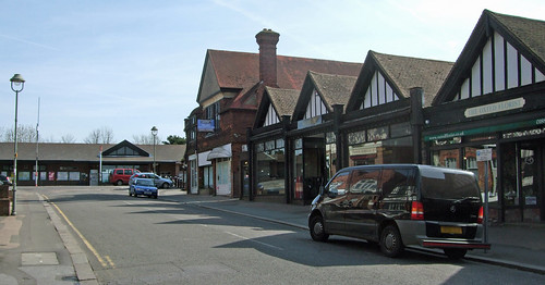
Thanks to that Sunday bugbear, engineering works, I start today's walk at Oxted rather than last week's end point of Hurst Green -- it's only a little further from our route. As a settlement Oxted dates back at least as far as Domesday and expanded as a coaching point in the 18th century when the east-west road through it was turnpiked. Further expansion arrived with the railway, opened jointly by the London & Brighton and the Southeastern railway in 1884, giving this bucolic spot at the foot of the Downs and near the head of the Eden valley a commuter link to London. The station ended up about 1km northeast of the village, and a new small town grew around it, much of which dates from the interwar years and is a riot of Tudorbethan of the sort that made John Betjeman chuckle, a solid urban building style of one era recycled as the fake rustic idyll of another. Station Approach, a shallow hill with elaborate half-timbered shop and business premises lining the route to the main station entrance, is actually quite impressive -- it certainly has a unified architectural theme.
My route leads from the other side of the railway back down towards Icehouse Lane, but rather than follow the obvious roads I make my habitual detours through back streets and paths, finding a semi-detached suburban cul-de-sac of the sort Ray Davies must have had in mind when he wrote, in Arthur: or, the Decline and Fall of the British Empire:
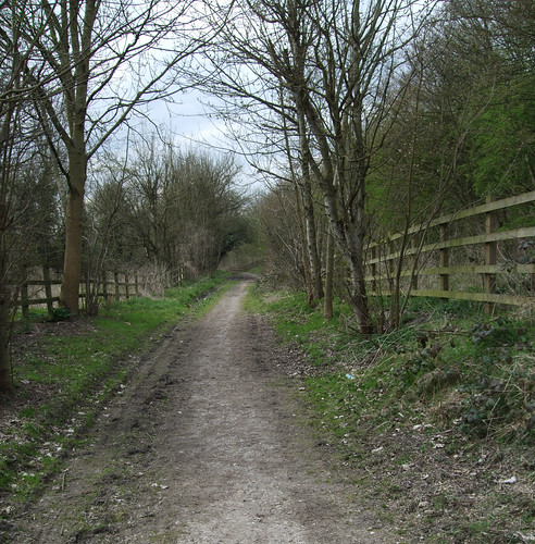
Here's your reward for working so hard.A convenient path between houses leads to East Hill, the former turnpike road that's now the A25, and on the other side a delightful hollow bridleway -- one of those urban discoveries that I suspect even some local residents don't know about -- threads between the backs of houses, emerging on Rockfield Road just short of where I left the route last week.
Gone are the lavatories in the backyard.
Gone are the days when you dreamed of that car.
You just want to sit in your Shangri-La.
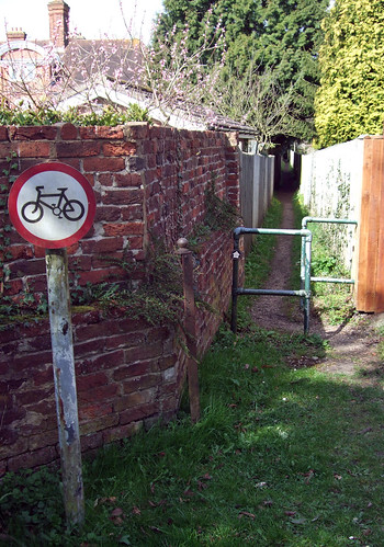
Rejoining the Countryway and what will be our final short stretch of the Greensand Way, I follow Icehouse Wood, a lane lined by big houses in leafy grounds of the sort once favoured by senior City types, which flattens out at what you can see on the map is a point immediately above the tunnel that takes the railway south from Oxted to Hurst Green and East Grinstead. Here a footpath branches off to the right which, when Keith Chesterton last updated his London Countryway guide in 1981, was accessed via what he notes as a curious wooden turnstile. I had a mental image of the bulky old turnstiles I saw preserved in the New York Transit Museum in Brooklyn, but sadly I find only a prosaic double tubular barrier of the sort designed to keep out cyclists but also frustrating to buggy pushers and wheelchair users. Next to it is a disused metal gatepost with hinges which I guess is a remnant of this now superceded barrier, a guess confirmed when I spot another one further down the footpath at a point where Chesterton mentions the remains of another turnstile. Otherwise this is another interesting stretch of urban footpath following a hidden route behind gardens -- long may it be kept safe from gating orders.
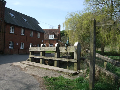
A short stretch along a lane then brings me to the pretty setting of Oxted Mill or, more correctly, Oxted Middle Mill --plain Oxted Mill was a little way west but has since been demolished. Both sites are beside the upper reaches of the river Eden, here a modest stream which rises up on the Downs near Titsey and flows into the Medway near Penshurst, Kent, its waters thence reaching the Thames estuary. The name of the river is that linguistic curiosity, a back formation. One of the major towns through which it flows, some distance downstream from here, is called Edenbridge, from Eadhelm's Bridge, Eadhelm being a person. But subsequently people assumed the bridge was named after the river, which then became universally known as the Eden. A walking route, the Eden Valley Walk, follows the river from Edenbridge downstream to Tonbridge, linking to the Wealdway, Medway Valley Walk and Vanguard Way. Middle Mill, looking very picturesque next to its millpond, was formerly a corn mill and is now used as offices.
The mill is the point at which the Countryway finally bids farewell to the Greensand Way and strikes northwest towards the North Downs. The Greensand Way, originally proposed by walkers' groups who were successful in getting both county councils covering the Greensand Ridge on their side, was developed in the 1980s and only finalised sometime after Chesterton published his last update to the Countryway, but since both routes aim to follow the ridge, it's not suprising that they choose many of the same paths. The route starts at Ham Street, on the Saxon Shore Way and not far from the south coast, and if you chose to follow the waymarks from Oxted Mill they'd take you as far as Haslemere in Surrey, nigh bang-on the boundaries of Hampshire and Sussex.
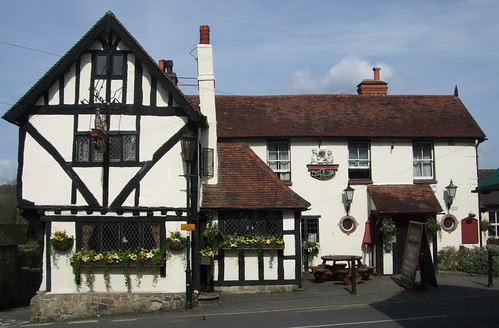
There's a pleasant piece of waterside walking beside the mill pond and the Eden and through some damp woodland before rejoining the residential area. Cresting a hill I spot the distinctive brown ridge of the Downs ahead, still recognisable from when I last left it just north of Coldrum longbarrow near Trottiscliffe. The route descends to what's now Old Oxted, the original village, a quiet spot since the main road was diverted a little to the north in the 1960s. At the crossroads is the 15th century Old Bell, an impressively large hall house no doubt much expanded when the road was turnpiked and expanded again several times since, including in the 2000s. Today it's part of the Chef & Brewer pubco, ultimately owned by Heineken.
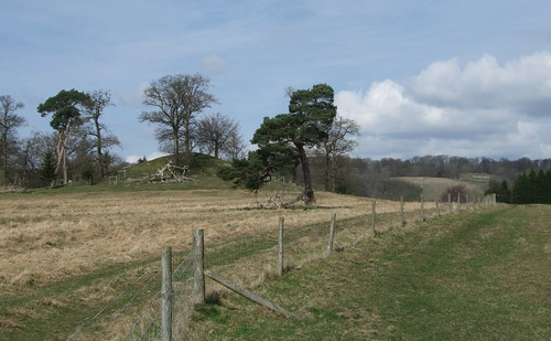
Under the A25 bypass and along pleasant field paths, now well under the shadow of the chalk ridge, the route passes a dumpy little 9m hillock sprouting a few trees -- Barrow Green Mount, once thought to be an ancient burial site but more likely to be the remains of a Norman motte and bailey that was once incorporated in the parkland of nearby Barrow Green Court, dating from the 17th century.
Barrow Green Court turns out to be today's real curiosity. Chesterton remarks in 1981 that the estate has recently become surrounded by tall fences and protected by guard dogs, and wonders "what secret business can be going on that has to be protected so securely and so hideously." Chesterton didn't have the benefit of the internet: a quick search reveals that the house has been owned for decades by millionaire businessman and Harrods and Fulham FC owner Mohamed Al-Fayed (b1933). Though he's now based in Switzerland, until 2002 this was his principal home, and is the burial place of his son Dodi, boyfriend of Diana Princess of Wales, who died alongside her in a car crash at the Pont d'Alma tunnel, Paris (another spot I've visited on a walk), in August 1997. I'll resist discussing Diana and the cult that has grown up around her here -- I got in enough trouble online the day she died -- but I wasn't expecting to encounter a connection with this particular incident of recent British cultural history on the walk.
Given its owner's well-publicised adherence to conspiracy theories, it's no surprise that the security measures have been enhanced since Chesterton wrote, with CCTV cameras now sprouting over the tall fences. As I walk down the bridleway beside the house, I hear the whirr of servo motors and see that one of the cameras is tracking my progress. I stare right at it, smile and wave. The camera stops, then tips down and up in what is umistakeably intended to be a nod of acknowledgement. No doubt the person operating it considers s/he has a good sense of humour but I feel a shiver down my spine on this sunny early April day and hurry swiftly by.

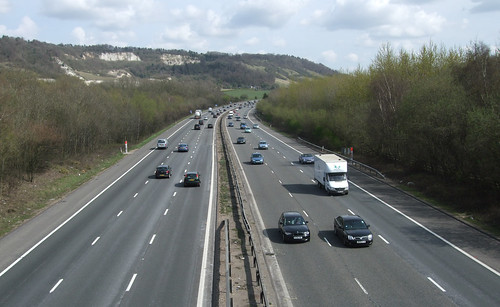
Having just crossed the A25, I make my first encounter with its motorway namesake, the London orbital M25, the first piece of purpose-built infrastructure we've met that's designed to encircle London. The motorway is the culmination of successive proposals for fast traffic routes round the capital, dating back to 1911 and the earliest proposals for what became the North and South Circulars. As such it's a paradigm case of the "predict and provide" model that has for so long dominated transport planning in Britain: predict how much travel by private motor vehicles is set to grow, and then build the roads to provide for it, without ever questioning the logic of uncontrolled growth or recognising that provision in itself can stimulate demand.
Generations of British drivers far less rabid than Jeremy Clarkson have grown up in the belief that the answer to congestion is simply to build more roads. In practice all that happens is that demand soon outstrips supply, the new roads quickly become choked in their turn. Meanwhile public transport, walking and cycling continue to decline and people are driven even further into car dependency. Thus when the complete circuit of the M25 was completed in 1986, an icon of the Thatcher years officially opened by none other than Margaret Thatcher herself (a woman who once declared that anyone over 30 seen on a bus should be thought a failure in life), it was already inadequate for the levels of traffic that attempted to use it, soon tagged by detractors the world's biggest car park. Since then it has been widened further in many places, but is still often congested.
Historically the M25 wasn't planned as a single orbital -- although plans for a broadly similar route date back to the 1930s, the motorway as it exists was only upgraded to an orbital when ringway schemes through the metropolitan area itself fell through. This section is one of the earliest, dating from 1979, and was originally planned as a relief road for the A25, connecting with the M20, thus its numbering. At one stage the outer ringway to the north of London was designated M16, but the two schemes were combined simply as the M25 in the late 1970s.
Setting aside the practical transport and environmental issues, the M25 has quickly earned a status as a cultural icon, from its role in facilitating wildcat "rave" parties in the late 1980s (from which the band Orbital got its name) through Iain Sinclair and Chris Petit's 1999 psychogeographic pilgrimage to Neil Gaiman and Terry Pratchett's reimagining of the road as a giant sigil shaped by demonic forces in Good Omens (1990). I stand watching the traffic shooting past below for some time, thinking of the differences in experience engendered by such extreme differences in speed. The motorway is 100km/h architecture, designed for fast movement and broad brush perception, the driver's eyes fixed on the road ahead, cued by the limited visual vocabulary of lined carriageways and giant signs, further insulated from the landscape by an alignment selected for flatness and cuttings and embankments that elide the natural relief. On foot, wandering over the bridge, you perceive every detail, from the chalk pebble on the path right up to the chalk downs shaping the landscape. The driver's eye view seems a little like an alternative topography superimposed on mine. In the photo I take, I can just about catch a couple of faces in passing cars. I doubt they catch me.
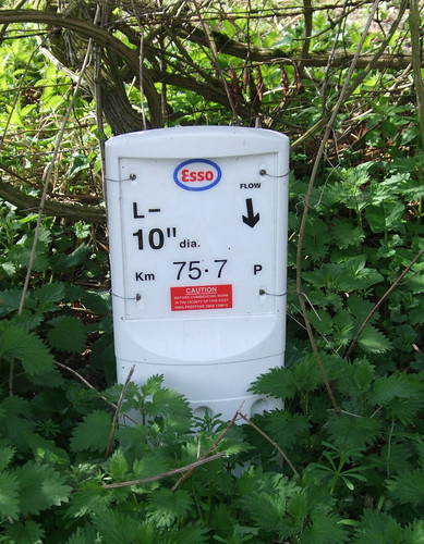
On the other side of the motorway, now back in the Surrey Hills Area of Outstanding Natural Beauty, I start to climb sharply up the ridge at last, on a rough path now white with chalk underfoot. At the side of the track I notice a small white sign with an Esso logo which, judging by the reference on it to flow direction, marks an underground oil pipeline. As I discover when I get home, thereby hangs another tale. Think of oil and you normally think broad and bleak, like the North Sea, Texas or the Saudi desert, but there are still pockets of black gold even in England, including here under Oxted. It's known as the Palmers Wood oilfield and in 2006 Mohamed Al-Fayed discovered that some of the oil was being extracted from his land, though the company, Star Energy, had attempted to conceal the fact since starting its pumps in 1990. He sued for trespass and in 2008 was awarded a 12.5% stake in the profits. While there's a tempting irony in the story of an Arab businessman cheated of oil in a Surrey backwater, Al-Fayed made his initial fortune from arms dealing, shipping and hotels.
Reaching the crest of the ridge and entering Marden Park Woods, I find myself for the first time on the property of another institutional land manager dedicated to both conservation and public access, the Woodland Trust. Founded in 1972, it's since grown rapidly to an estate of almost 200km2 (though still considerably smaller than the National Trust), and does particularly well from legacies, the thought of leaving a tree (or a wood) behind having a clear appeal to those pondering their mortality. We'll be seeing more of its double oak leaf logo. The top of the ridge sees us meeting again with the North Downs Way National Trail, also part of European route E2, last encountered near Trottiscliffe. Unlike the Greensand Way, this was already established when the London Countryway was devised, and we'll soon be following quite a bit of it -- you could if you wish shave off a couple of kilometres by simply turning left at this point -- but for now Chesterton chooses to keep straight ahead across it, for reasons that will soon become apparent.
I find myself following waymarks for the Woldingham Countryside Walk, and with this comes to a link to the roots of London's modern network of walking trails. In 1988, in recognition of the special pressures on the green belt landscapes of these fringes of London and northeast Surrey, the various local authorities formed a partnership, the Downlands Countryside Management Project, to manage them in a more coherent way. The project, which extends over the boundary into the London Borough of Croydon, found a visionary project manager, Alec Baxter-Brown, who is also an advocate of improved access through good quality walking routes, and set about creating a set of circular routes throughout the area. Around the same time, the London Walking Forum was set up largely through the work of Ramblers volunteers, bringing together representatives from the London Boroughs in these post-GLC, pre-GLA days to champion a network of green walking routes. Baxter-Brown, who still manages the project today, was an energetic voice in the Forum and played a role in creating its first flagship project, the London Loop. The Forum was enormously influential, not only in London but nationally and internationally, and I'll have a lot more to say about it when I walk the Loop, but here is an early trail for it in the first Downlands walk we've come across on the Countryway, and a sure sign we're drawing closer to the boundary.
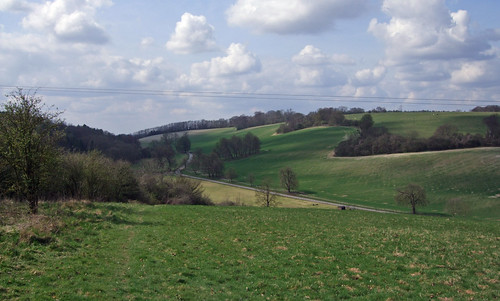
Emerging from the woods I realise why Chesterton judged this dogleg detour from the line of the Downs worthwhile. The landscape opens out onto a lush green valley, the Marden Valley, both sides crowned with trees and a cluster of buildings below. Considering the proximity of suburbia, it's a hidden and peaceful place, with a scattering of people out and about, several of them content to bask on the grassy slopes enjoying the quiet.
I descend to the buildings, passing an old horse trough now overgrown with shrubby trees. The original village was wiped out by the 14th century Black Death, but the house and grounds of Marden Park were occupied as a country estate in the early 18th century. In the 1790s anti-slavery campaigner William Wilberforce lived here for a while -- we'll meet him again on the Loop. The Society of the Sacred Heart moved its convent school here in 1946 after its site at Roehampton was damaged in air raids, and it remains an independent Catholic girls' boarding school, now known as Woldingham School, its campus occupying the valley floor. There's a modest little cemetery at the bottom of the hill which at first glance looks like a Commonwealth War Grave, but the headstones are mainly those of convent members, each described as a "religious of the sacred heart". An elaborate outdoor crucifix, a rare site in England, presides, reminding me of Belgium again.
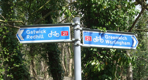
Several of the surfaced drives through the campus are open as public paths and cycleways. From here you can continue along the Woldingham Countryside Walk to Woldingham itself, named by the Telegraph in 2007 as the second richest suburb in Britain, but the Countryway tracks for a short distance a section of National Cycle Network Route 21, the Downs and Weald Cycle Route. Part of a network championed by Sustrans, this route starts a short stroll from my flat at Greenwich and in its early sections follows the Ravensbourne and Pool valleys as the Waterlink Way -- much of it is off road and also makes for good walking, so we'll explore it again when I finally get round to the north-south routes across the capital.
Passing the old house itself, a large and impressive red brick building, I cut away from the surfaced track, almost doubling back on myself to climb through a woodland on the opposite side of the valley, a path which in 1981 had, according to Chesterton, only just been cleared but which is now easy to follow and well-waymarked. Emerging from the woods near the top of the slope, there is a superb view south: the valley has driven a gap through the chalk, which humps on each side like rolled back bed covers, framing the Weald beyond. I'm struck by the discrepancy between the mental picture I formed of this area while studying the map and the reality: misled by the jagged smithereen-edged line of the paths, I imagined somewhere sharp, bleak and airy, not these soft slopes and rather intimate sense of peace.
Fields lead back into woods and a steep descent on rough wooden steps. On the other side of a fence I spot some people dressed in faux mediaeval costume, carrying staffs and toy swords, and, curious, I hail them. One of them, Richard, approaches me, wielding a rather anachronistic clipboard, and agrees to a quick interview -- it's live action role playing, like Dungeons and Dragons only in the outdoors and physically acting out the encounters with padded weapons. He knows that I know admitting involvement in such pastimes is potentially embarassing, but makes a good confident go of it, and I wish him a good day's gaming. Actually I approve of the imaginative projection of your own alternative reality onto this landscape, and these ancient woods, which must look much the same as they've done for millennia, provide as good a backdrop as any.
Quarry Lane at the bottom of the hill is more industrial in character. An enclosed building ahead displays a poster for the Wealden Cave and Mine Society, who among other things operate Reigate Caves, as well as exploring the many quarries that riddle this part of the world. I'm not sure if there is a reason why the poster is in this particular spot -- are there caves and mines in the vicinity? There are certainly caves and wines, as just down the hill from here is Godstone vineyard, surely one of the nearest vineyards to London, reminding us that the European wine belt just about creeps this far. It's a shame there isn't actually a vineyard in London -- there's one in Paris, right on top of Montmartre. Since the section after next actually passes through Denbies vineyard near Dorking I'll reserve saying more about English wine until then.
The North Downs Way loops around this section on a path, but I'm temporarily mesmerised by NCN21 signing that points to Greenwich, and follow the hard surfaced track which passes through the yard of a furniture hire company.
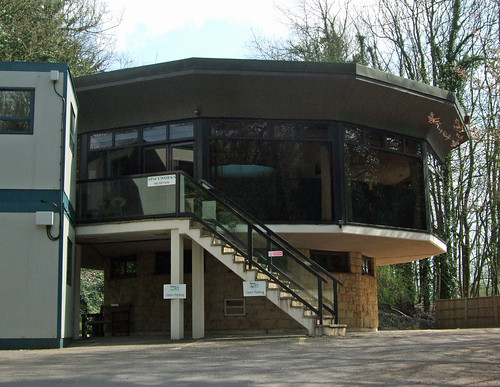
On one side are large warehouses with vast loading bays; on the other, an unexpected treat, the company's offices appear to be housed in a smoked glass modernist building shaped like a octagonal toadstool and accessed by a footbridge, faintly reminiscent of John Lautner's Chemosphere and the sort of place where people from the future might hang out in 1970s science fiction TV programmes. Even the company name, Spaceworks, is on message, though the effect is rather spoiled by a couple of stacked portakabins.
Though this section of the London Countryway more-or-less tracks the North Downs Way (and therefore the E2 European route), Chesterton sometimes deliberately detours away from it, aiming, as he says, for variety of landscape rather than purity of line. I notice his description here doesn't correspond to the route of the national trail mapped on the OS Explorer or signed on the ground, but I conclude the differences aren't intentional, and the NDW alignment has been improved since the Countryway guide was published, so I stick to the acorn waymarks. These soon lead to a footbridge across the deeply cut dual carriageways of the next major trunk road to cross, the A22, which peels off the A23 London to Brighton road at Purley heading for Eastbourne. This is still another turnpike road, dating from 1718, although of course it's been realigned and widened -- I suspect the track that takes us north towards the footbridge parallel to the road is an earlier incarnation of it. The section just to the north of here is the Caterham bypass, one of the earliest bypasses in Britain, dating from the 1930s and reputedly haunted by the ghost of a young girl.
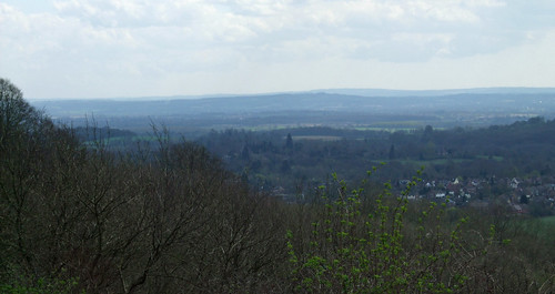
A stroll through woods on the other side takes me along a chalky ridge track typical of the North Downs Way, rounding an earthwork of some kind that appears on the map as Pilgrim Fort, though I can find no further information about it. I soon emerge on an open green with wide views below -- Tandridge council's Caterham Viewpoint site, where I sit on a bench and eat my lunch. The view is truly spectacular, with the M25 down in the dip, the Greensand Ridge rising up on the other side, the Weald beyond and, further still, a faint smudge that must be the South Downs, some 4okm away. Various people are about, quietly and modestly enjoying the space. Several walkers pass, a man and a boy cycle past on off-road bikes, an older couple sit holding hands, a young and very healthy looking woman in a tracksuit strides past, power walking with weights. Two young men and a young woman, speaking Polish, kick a ball about, and one of the men obligingly takes his shirt off.
Back into the woods, NCN21 finally leaves our route at a fork, heading for Redhill and Gatwick Airport. Further on the track climbs through woods to emerge on the outermost residential edge of Caterham, on the curiously named War Coppice Road, named after a house that once stood here. The route follows this quiet road for some distance, a stretch that's just outside the official boundary of the AONB, passing the site of an Iron Age hillfort on the left with a view to Leith Hill and, just before the end, a crumbling tower standing alone in a field which, with its white stone and flint, at first glance might be the tower of an abandoned church but lacks any gothic detailing. It turns out to be a folly, White Hill Tower, built at this high vantage point by a certain Jeremiah Long in 1862.

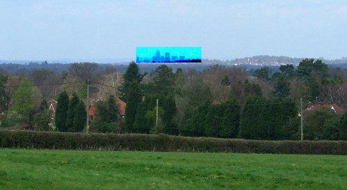
Reaching the junction with Whitehill and Stanstead Road, with the historic Harrow pub just off to the right and heritage dating back to neolithic times nearby, I'm gratified to spot signing for a branch of one of the first Downlands Project walks, the Downlands Circular Walk, a route that actually straddles the boundary and links to the London Loop. Following it back into the AONB down a clear farm track that descends White Hill and then climbs to anther chalk ridge, there is much more explicit evidence London's proximity -- there, on the horizon off to the right, is the unmistakeable shape of the cluster of buildings that now make up Canary Wharf, with the pyramid shaped crown of the original tower clearly visible, though I'm too far away to catch the flashing light on top. Looking more closely I spot other landmarks -- just to the left I can see Tower 42 (the NatWest tower) and the St Mary Axe gherkin, and isn't that Centre Point a bit further over, with Parliament Hill and Highgate Hill behind? Canary Wharf, that eruption of a US downtown miraculously transported to Docklands, has now become such a dominating landmark of the capital you could imagine an alternative London boundary based on its sightlines. Finally I feel I've climbed to the crest of that chalky wall round London and am looking down on the the other side. As the Docklands view disappears behind trees I wonder when I'll see it again.
The track bends past the schoolboy snigger-inducing Willey Park Farm, with several dismantled sections of gliders in the farmhouse garden, and reaches a curious two-storey flint barn. Here there are more connections: a branch of the Socratic Trail, a largely unsigned route between Old Coulsdon and Brighton devised by the late Maurice Hencke of the Croydon-based Socratic Walkers, heads south here.
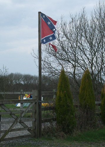
A little further on, past a horse paddock that for some reason is flying a third of the Confederate flag (I hope it's nothing more dubious than a complement to the Western look of the wooden corral, or perhaps they're Lynryd Skynryd fans), is a fingerpost marked Three Way, where a northward branch of the Downlands Circular Walk makes the most convenient connection yet with the London Loop. This is one of the closest points that the Countryway approaches the Greater London boundary, with a southwards-jutting tooth of Croydon only around 1.5km away.
I don't turn north, however, but continue west along the North Downs Way, which, as a wooden fingerpost soon reminds us, is also at this point tracking the historic route of the Pilgrims Way. Soon, off to the left I catch a fine view of Merstham and Redhill beyond, dramatically framed by a tree bough. Then the national trail emerges from the enclosed track, where another northward stretch of the Downlands Circular goes ahead and off right to Tollsworth Manor. My route strikes off diagonally across a field, tacking the hillside on a steepish descent. A short way along, though with nothing to notice on the ground, we cross the boundary between Tandridge District and Reigate & Banstead Borough.
Merstham, as you can plainly see from the slope, nestles beside a large knot of motorway where the M25 meets the M23, taking London traffic southward to Brighton. Both motorway sections were built in the early 1970s and originally the M23 was planned to stretch far into south London, thus the size of the three tier junction, one of only three of this design in the UK. The northernmost part of the scheme was later cancelled, and the M23 remains a long-deferred relief for traffic that's plodded stopping and starting through Brixton, Streatham and Coulsdon, but the big knot remains. A scrubby area of what feels like waste ground comes next, no doubt "blighted" by the motorway and left as a rather attractive marginal space, with the motorway itself crossed in a tunnel.
On the other side is more waste ground on the site of an old quarry, where the track heading off to the right is a legacy of an earlier form of mechanised transport, as it follows the alignment of the Surrey Iron Railway, Britain's first working stretch of public permanent way. Originally planned as a canal, the horse-drawn 1270mm (4' 2") gauge line was opened in 1802 between Wandsworth, Mitcham and Croydon and extended to the quarries at Merstham in 1805, though this section closed in 1838 and very little evidence remains, while parts of other sections are still in operation as the Croydon Tramlink.
A short walk brings us to residential Merstham and a street of largish houses -- a sprawling piece of mock Tudor reminding me of our starting point at Oxted and, further down, a Dutch-style farmhouse hiding under low eaves like a pulled-down hat. Just before this, and now out of the AONB again, the Countryway leaves the North Downs Way briefly, picking up another urban footpath threading between gardens and through another patch of scrub to make its crossing of the M25 -- the last we'll see of it until we get all the way round to Waltham Abbey, as from now on the route runs outside it. Chesterton admires the curvature of the footbridge at this point but the bridge he used must have fallen victim to a widening scheme, as the current bridge is a chunky girder affair, not unpleasant but exhibiting no elegant curves.
On the other side the right of way cuts purposefully down an embankment and across an urban green space, Radstock Way Open Space, facing social housing, while zigzagging surfaced paths take a gentler but longer route. Here we lose the Socratic Trail, which keeps ahead through the recreation ground opposite, while the Countryway heads under a railway bridge and arrives almost immediately at the station, passing right through on the footbridge between platforms.
The line was opened in 1841 as part of the London & Brighton Railway's route to the south coast, but the government of the day insisted it was developed jointly with the South Eastern railway's route to Dover. The original LBR station was some distance south of the present one, but was closed in an effort to frustrate the competition by making it inconvenient for passengers to change between the two companies. The current station is the SER one, opened in 1844 although the current pleasantly rustic low-rise building and the footbridge date from 1905. Today it's served mainly by trains on the Brighton route, although only local ones that don't venture further south of East Grinstead or Horsham, and trade under the name Southern.
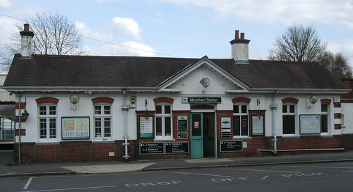
And though outside the GLA area, Merstham is in the outer reaches of TfL territory, with red buses providing two or three services an hour to Croydon from London-style bus stops complete with TfL roundel, though Oyster cards aren't valid. With time to kill before my train, I also find a pretty village centre with war memorial, and a greasy spoon caff that's open for cups of tea on a Sunday. A fine place to finish a London walk.
View a map http://maps.google.co.uk/maps/ms?ie=UTF8&hl=en&msa=0&msid=117966169375523396049.00046414d40d8252e7b70&ll=51.414197,0.368729&spn=0.106206,0.219727&t=h&z=12
Route description pdf
More information
- Surrey County Council http://www.surrey.gov.uk/
- Surrey Countryside http://www.surreycc.gov.uk/countryside
- Surrey Interactive Maps http://surreymaps.surreycc.gov.uk/
- Surrey Walking (John Harris) http://www.walkinginsurrey.co.uk/
- Visit Surrey http://www.visitsurrey.com/
- Exploring Surrey's Past http://www.exploringsurreyspast.org.uk/
- Surrey Hills AONB http://www.surreyhills.org/
- Tandridge District Council http://www.tandridge.gov.uk/
- Visit Tandridge http://www.tandridge.gov.uk/LifeinTandridge/Tourism
- Tandridge Border Path http://www.tandridge.gov.uk/LifeinTandridge/Leisure/Walks/tandridge_border_path.htm
- Greensand Way http://www.kent.gov.uk/leisure-and-culture/explore-kent/walking/greensand-way-walk.htm
- Oxted Parish Council http://www.oxted-pc.org.uk/
- Oxted Line (Wikipedia) http://en.wikipedia.org/wiki/Oxted_Line
- River Eden (Wikipedia) http://en.wikipedia.org/wiki/River_Eden,_Kent
- The Mount, Barrow Green (Historic Environment Record) http://www.exploringsurreyspast.org.uk/GetRecord/SHHER_1246
- M25 (Wikipedia) http://en.wikipedia.org/wiki/M25_motorway
- M25 history (The Motorway Archive) http://www.iht.org/motorway/londonm25.htm
- National Trails http://www.nationaltrail.co.uk/
- North Downs Way National Trail http://www.nationaltrail.co.uk/northdowns/
- Woldingham Village http://www.woldingham.com/
- Woodland Trust http://www.woodlandtrust.org.uk/
- Marden Park Woods (Woodland Trust) http://www.wt-woods.org.uk/MardenPark
- Sustrans http://www.sustrans.org.uk/
- NCN 21 http://www.sustrans.org.uk/default.asp?sID=1099053270109
- Downlands Project (including Woldingham Countryside Walk and Downlands Circular Walk) http://www.surreycc.gov.uk/downlands
- Woldingham School http://www.woldingham.surrey.sch.uk/
- Godstone Village http://www.godstone.net/
- Godstone Vineyard http://www.godstonevineyards.com/
- A22 (Wikipedia) http://en.wikipedia.org/wiki/A22_road
- Caterham Valley Parish Council http://www.caterhamvalleypc.org.uk/
- Bletchingley Village http://www.bletchingley.org.uk/
- Caterham (British History Online) http://www.british-history.ac.uk/report.aspx?compid=43062
- Chaldon Parish Council http://www.chaldonpc.org.uk/
- Socratic Trail (LDWA) http://www.ldwa.org.uk/ldp/members/show_path.php?path_id=421
- Reigate & Banstead Borough Council http://www.reigate-banstead.gov.uk/
- Reigate & Banstead Parks and Countryside http://www.reigate-banstead.gov.uk/public/Leisure/Parks_countryside/
- Reigate & Banstead Tourism http://www.reigate-banstead.gov.uk/public/Leisure/Tourism/
- Merstham http://www.merstham.co.uk/
- M23 (Wikipedia) http://en.wikipedia.org/wiki/M23_motorway
- M23 (Motorway Archive) http://www.iht.org/motorway/m23londpeas.htm
- Surrey Iron Railway (Wikipedia) http://en.wikipedia.org/wiki/Surrey_Iron_Railway
- London Brighton & South Coast Railway (Wikipedia) http://en.wikipedia.org/wiki/London,_Brighton_and_South_Coast_Railway


1 comment:
Thanks for a comprehensive account. I've just been visiting in the Oxted area from Germany and was glad to get some more details on the Tudorbethan houses in Oxted and Al-Fayed's property, as well as all your other fascinating insights.
Diana
Post a Comment