Update October 2018. This post has been superseded, though I've left it online for historical reasons. For more recently updated and expanded details of this walk see London Countryway 2: Sole Street - Borough Green.
Today's walk is very much a rural one, a reminder of how much London offers to those who prefer urban life but appreciate classically attractive countryside near at hand. A short train ride from Victoria and we're in a landscape of rolling hills, woods, hedgerows, quaint cottages and village churches that's everyone's stereotype of rural England. The economic forces that shaped this landscape are long since changed beyond recognition, though it may try to fool you it's still part of an unchanging and ever present past, but you can recognise its essential artificialities and still enjoy it. The more permanent, natural and thoroughly material substrate below it all is the geology which, if you care to look and think, illustrates some of the key physical preconditions that shape the city we know today.
Geology is a curious thing, a set of processes outside human or animal influence, with timescales so slow they approach immutability. Its reference frame is not society or history or culture but the universe, its matter the stuff of solar systems -- though an atmosphere makes things more interesting, lifeless planets do geology too. The power to influence geology through will, like the Prophet moving his mountains, still seems remote and even god-like even in science fiction, where terraforming is often presented as the ultimate technological milestone of the most advanced civilisations. And while that may be changing, if global warming theory is to be believed, it's still a bit cold and scary to feel insignificant out here where the universe just gets on with things as it always has. The palaeozoic rocks of the "London platform", at the deepest levels beneath London, are more than 400 million years old, a length of time so vast it seems meaningless.
The next layer up, and the one that will interest us most today, is admittedly a product of life, though there was certainly no conscious agency involved. During the Cretaceous period, 142-65 million years ago and before even the formation of the Alps, a tropical sea washed over these rocks, and the calcium carbonate shed by microorganisms inhabiting that sea collected as a bed of what has now become chalk, a particularly pure form of limestone. This was later smothered by clays and gravels, but subsequent millennia of erosion have exposed the underlying chalk as ridges along the edges of the chalk shelf to create the structure known as the London Basin. London itself sits within a triangle of chalk, with the edges marked by the North Downs in the south and the Chilterns in the northwest while much of the eastern edge is submerged by the Thames estuary. The Thames runs roughly east-west through the basin, but its own drainage basin stretches much further west -- the basin long predates the river, which once ran on a more northerly course, until forced into its present route by the ice shelfs of various ice ages.
The chalk hills, with their shallow dip slopes reaching inward towards the city and their steep, wall-like scarp slopes facing sternly outwards, form one of the more concrete boundaries of London. They are part of a bigger system of chalk deposits that covers much of southern and eastern England and stretches to Champagne in France, with skeins of chalk hills sweeping from Dorset to the Yorkshire Wolds. They were firmly established features of the scenery when humanity first walked across the land bridge, and they played an important role as early channels of communication, scored along their length by ancient trackways that probably began as animal tracks and in some cases now form part of the modern road network. Today they provide leisure opportunities close to some of Britain's most populated areas, but the springy tracks and airy open views most people associate with downland are a result of human management, particularly for grazing -- left to their own devices, like most of England they quickly revert to woodland, which is how the first downs walkers must have found them. Some sections, including those we'll discover today, are wooded still.
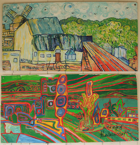
Arriving at Sole Street station I notice something I didn't see last time -- the wooden shelter on the down platform is decorated with several curious paintings of local scenes in the style of well-known painters -- Meopham as interpreted by John Piper, Vincent Van Gogh, LS Lowry, Wassily Kandinsky, Friedensreich Hundertwasser and Paul Klee. The pastiches are crude ones (the Lowry one flatters the artist not through the effectiveness of its homage but by reminding us that Lowry was actually much subtler than many people give him credit for), the works are damaged by grafitti and the Hundertwasser piece is particularly garish, but they certainly have some curiosity value. No credits or explanatory plaques are obviously visible.
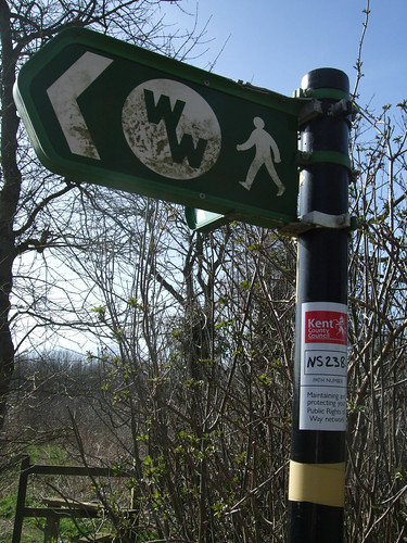
Opposite the station approach, the London Countryway leaves the Wealdway, the first of several such partings today as the two routes intertwine round each other like hesitant suitors before finally going their own way, and immediately enters the Kent Downs Area of Outstanding Natural Beauty (AONB). AONBs are an example of when an ordinary English phrase sprouts upper case initials and becomes a Designation, not any old area of outstanding natural beauty but one which through some established statutory process has been judged Outstandingly Naturally Beautiful by civil servants, council officers and politicians. It seems a curious thing that an aesthetic, subjective judgement can be institutionalised, with public officials and lobby groups debating what is and is not Beautiful, and whether or not the Beauty is sufficiently Beautiful as to be deservedly Outstanding, and inevitably these judgements err in favour of rather traditional conceptions of rural beauty rather than, say, the beauty some of us might see in a derelict industrial site or a tranche of particularly interesting early 20th century social housing.
AONBs are also curious in being something of an uncomfortable Championship League to National Parks. Both designations result from the same post-war legislation, both are structures for managing areas of land in mixed and private ownership (unlike national parks and their equivalents in many other countries, where most of the land is in public ownership), and AONBs will tell you their landscapes are just as valuable and Beautiful as national parks. But it's obvious they were created as "national parks lite", in recognition that the resources needed to set up a national park -- which has its own planning authority -- simply were not available to cover all the most deserving landscape areas. AONBs are managed by partnerships of local authorities, and offer less protection than national parks. Still, they've undoubtedly protected some fine areas, and Londoners in particular should be grateful for them as they're the best protected large areas within easy reach of the capital. Both ranges of chalk downs--the North Downs (covered by two AONBs, the Kent Downs and Surrey Hills) and the Chilterns -- have AONB designations, while another, more southerly, chalk ridge, the South Downs, currently an AONB, is about to be upgraded to London's closest National Park.
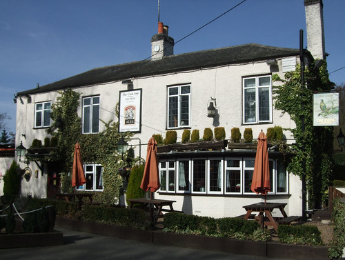
I strike out in a straight line across a broad field, along a lightly but clearly defined path, one of those that now seems so firmly impressed on the turf it will re-emerge even if ploughed and cropped. On the edge of the hamlet of Henley Street, I pass the Cock Inn, Luddesdown, a solid rural pub dating from 1713 and a multiple local CAMRA award winner for its range of interesting real ales -- the sort of place I'd hope to stumble upon at the end of a walk, but it's too early in the day and the walk to pay a visit.
From Henley Street things start to get more rolling, with fields that fold and dip into dry valleys. I cross the Wealdway again, and chat to a local couple doing their regular Sunday rounds -- "six or seven miles", they tell me. This mid-March day has become quite glorious and they won't be the first I meet who are out enjoying it.
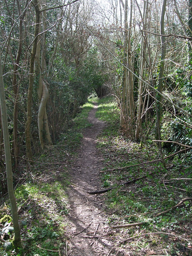
I'm soon heading south through woods along a path that follows the edge of a wooded ridge in the lesser-known northern area of the Kent Downs, an offshoot of the main line of chalk. I can understand why the creator of the London Countryway, Keith Chesterton, chose this route as an alternative to the more established Wealdway -- it's exactly the sort of long and interesting stretch of path a route developer would apply all their ingenuity to incorporating into an itinerary. It's slightly muddy and uneven and in places a little precipitous, clinging to contour a few metres down from the crest of the ridge, and through the trees, not yet in leaf, there are glimpses of open country. Wild primroses are in the dense undergrowth.
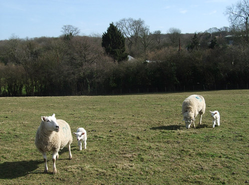
Finally I emerge from the trees to a sweeping view below from a field edge churned by cattle. Sheep, the traditonal livestock of the downs, are also about, and it's the lambing season -- a ewe bad temperedly stamps her front hooves at me, warning me away from her babies. Beware of aggressive sheep.
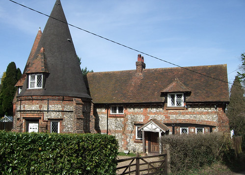
At a junction of paths in a dry valley just north of Harvel I run into a cheerful group of children and a smattering of parents being shepherded by older fleece-clad and boot-shod people brandishing map cases and trekking poles. It turns out to Meopham & District Footpaths Group (who, incidentally, also publish their own leaflets of walks through local outlets) conducting local school students on a fundraising walk. One of the map case carriers has opinions about the way I should walk, with good intentions but it puts me off and I get slightly lost on the complicated path junction. Back on track, I emerge on a lane just north of Harvel, by an intriguing cottage with a cylindrical-shaped wing. It's presumably an oast house -- a structure formerly used for drying hops -- that's been converted for residential use, but I'm pleased to find a circular house on this outermost circular route. I seem to recall that people once built round houses so there would be no corners for evil spirits to hide.
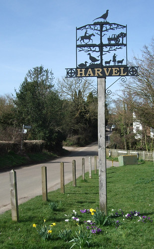
Harvel is a picturesque place with a green complete with duckpond and village sign, installed to mark the millennium in 2000. According to Wikipedia, in 1950 it was one of the signal receiving points for the first live television pictures transmitted to Britain from mainland Europe. The village sign depicts traditional agricultural images of tractors, sheep and sheperd, ducks and horses in silhouette.
It's the horses that seem to be most important, though, as my path now takes me through a large equestrian centre over a series of chunky wooden stiles.
East of Harvel I rejoin the Wealdway for quite a lengthy section leading across the downs ridge proper. First there's the very Kentish-sounding Whitehorse Wood, still managed commercially by the traditional woodland technique of coppicing. This involves cutting the trees right back to stumpy coppice "stools" just above the ground on a decades-long cycle to encourage the growth of a profusion of thin trunks for use as poles. Coppiced trees live to great ages and have a tendency to grow into spooky shapes, like massive gnarled hands, the sort that come to life in twisted fairytales. In the 1981 edition of his guide to the route, Chesterton reports that parts of this wood are being cleared, making it difficult to find the way. When I visit, some small sections have been recently cleared, but much of the scraggy woodland with its stick-cluster trees must be what's grown back in the 28 years since. A profusion of Wealdway waymarks ensure there is no chance of losing the trail. More of a problem is the mud, thick sticky clay-like mud that sucks on your soles. Nearing the southern edge of the wood, a crossroads of tracks has become a virtual pond, though it's possible to avoid it by picking through the trees. Much of the mud has been churned up by working vehicles, although the intrusive high-pitched fart of two-stroke engines not far off makes me wonder if there might be an off-road vehicle problem here too.
Immediately south of the muddy crossroads, a low woodbank crosses the path which I'm sure is a boundary marker, and in crossing it we leave Gravesham Borough for Tonbridge and Malling Borough, part of what the tourism people call "The Heart of Kent". A few paces further, a sudden flash of open country through the trees reveals I'm on the crest of the Downs, and the path instantly starts to descend steeply, cutting a diagonal line across the wooded scarp slope. At the bottom, I emerge by some houses on the east-west track that's traditionally known as the Pilgrim's Way, which here, as in several other places, also provides the official street name. Despite its Chaucerian flavour, the name is probably a Victorian invention, though the track itself is much older, one of those prehistoric highways that traces the line of chalk. This section also carries a more modern invention, the North Downs Way National Trail (also here part of European long distance path E2) -- we'll have more to say about both routes when we follow lengthy sections of them later, but at this point we share only a few metres of their alignment.
At the junction I discover the source of the noise -- four young men on quad bikes have pulled up and are deciding where to go next. "We can always go that way and meet them at the top," says one. "No, we can't," says another. "It's a bridleway." "Yeah, but it leads up to the top." "No, it's a bridleway, we're not allowed on it, we're only allowed on byways." "Yeah, but we could still go on it though." I tell myself off for being surprised at this rudimentary awareness of rights of way law (though "allowed" isn't the best word to use, but we'll consider that another day), but then I don't understand the attraction in these noisy, smelly vehicles even on byways. Still, they're doing better than the girl on horseback, out with her family on foot, who started off on the bridleway just around the corner but is now merrily cantering all over a growing crop.
After this brief dalliance with ancient trackways the Wealdway keeps decisively south, across the flatter open country between the Downs and the next geological formation, the Greensand Ridge, which is now rearing up some distance ahead of us. South of London the greensand and chalk form the rim of an eroded dome of clay and sandstone known as the Weald, which gives the Wealdway its name. The route was created in the 1970s by members of the Ramblers and, unlike the Countryway, its advocates were successful in engaging the support of local authorities -- Kent and East Sussex -- to recognise and sign it. As we've seen, it starts at Gravesend and crosses the North Downs; it goes on to cross the Greensand ridge and the Weald itself via Ashdown Forest before tackling the South Downs and ending at Eastbourne on the Channel coast, a total distance of 129km. We'll soon be taking a look at the Weald from the Greensand Ridge, but via a different route, so more about them then. Looking back at the wooded ridge I've just descended as it sweeps off into the distance to my east, all brown and forbidding, I feel I've crossed to the other side of the wall round London, and wonder whether I've strayed too far.
Very shortly the path passes by Coldrum Longbarrow, a relatively well-preserved neolithic burial chamber now owned by the National Trust which one held the bones of 22 people, some of which may have been deliberately broken, including "a skull on a shelf", until they were removed following early 20th century excavations and moved to Maidstone Museum. The structure has suffered badly from pillaging and landslips, most of the stones aren't in their original positions and the burial chamber is exposed, but they are still striking, especially in the dramatic setting below the Downs. On this beautiful sunny day it's hardly Frodo and Sam tangling with wights on the Barrow Downs -- ignoring the fencing, a couple are happily picnicing on top of the earth bank. It's a place favoured by morris men and hippies and I see a tree overlooking the site has been festooned with lucky ribbons, Chinese style. The two parallel slabs of the burial chamber point east, probably along a ley line. I'm more struck by how little we know of the pre-Celtic culture that for some reason mashed up the bodies of 22 men, women and children and buried them here, but I'm pretty sure the self-styled mystics who make a fetish of such places wouldn't survive there a day.

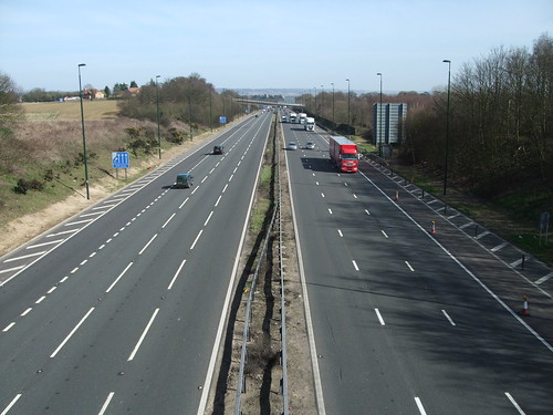
Reaching Trottiscliffe Road (it's pronounced "Trosley"), and noting a discarded Laphroaig carton that seems to indicate a better class of street drinker, I leave the Wealdway again and cross the first road with an advertised number I've encountered so far on today's walk, and it's a big one -- the M20, the main route from London to the Channel Tunnel and mainland Europe, and still rammed with the lorries of Norbert Dentressangle and the like even on a Sunday. This section was built in the early 197os and is thankfully crossed on a bridge. It's also a part of European route E15 from Thurso to Algericas, the ferry port for Morocco. I've always been disappointed these European route numbers aren't signed in Britain, even though they're a United Nations innovation, the work of bureaucrats in New York City rather than in Brussels.
Over the motorway, and leaving for the rest of today the officially designated Naturally Beautiful Area, I reach the pretty green at Addington, with its 14th century inn, the Angel, and stop to check my map. A passing driver bellows at me over a thudding baseline from his 4x4 -- "Rambler!" -- in that singsong football chant tone that people once used to shout "Skinhead!" at anyone with slightly short hair. I don't imagine it's intended complimentarily. But how odd that walking, something that everyone does, should yield its own special class of people. As if to bear me out, as I'm eating my lunch on the park bench, two men sit on the grass nearby, and with them is a boy toddler clearly only just past his first steps. The boy stumbles uncertainly but with obvious delight from the outstretched arms of one to the outstretched arms of the other. The men are delighted and proud. Alongside first words, first steps upright on your own two feet are treated as the most significant early milestone on the journey towards being fully human. The boy falls a few times, but rather than crying, he gurgles with laughter, picks himself up and tries again. A singing teacher once told me that singing is a form of controlled shouting, and watching a toddler reminds you that walking is a form of controlled falling. Elbows bent, palms up in front of him, this child is readily casting himself into gravity's well with each step, joyfully confident in the odds each step risked will pay off. How much we lose, and how easily.
The route through Addington passes The Seeker's Trust, a non-demoninational Christian "Centre for Prayer and Spiritual Healing" founded in 1925. The whitewashed residential buildings in their woodland setting, including another round house, look attractive, but the website turns out to be at least as full of bollocks as the people who do druidic rituals at Coldrum Longbarrow. The foundation of the Trust was apparently "guided by a ‘Dr Lascelles', a medical practitioner already in the spirit world...Healings are achieved through Harmony Prayer Circles of up to six people praying at Addington Park...[which] complete a triangle of power with spiritual beings whom we call Angels." When I come to map the route on Google, I see the Trust's star-like symbol has been recreated on a lawn, clearly visible in aerial photographs. There are more neolithic remains round here -- no doubt they help ground the triangle of power -- but I miss them, passing straight down the long drive past the rather blocky, squat St Margaret's Church, past some oddly half-submerged garages and through a recreation ground, where a footpath map and notes on the village are on display (also downloadable from the parish council website).
On the other side of the recreation ground is the first, but by no means the last, golf course we'll encounter on this journey. More so even than equestrian centres, golf courses seem a completely fake form of green space, with a completely invented and homogenous geography imposed in a stroke on the more organically evolved natural and human geography of a space. I guess it's also a class thing -- golf is a game for posh people who probably don't want the likes of ragamuffins like me traipsing across their neatly mown greens. In reality most golf courses accept and manage the rights of way that cross them, though the ones today could be better marked. The footpath runs rather dangerously along the end of the area where golfers practice their swing, with grass worryingly peppered by golf balls.
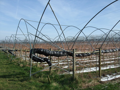
Much stranger is our first experience of what at the time Chesterton wrote his guide were still traditional orchards, part of the ancient industry that gave Kent the strapline "the garden of England." Over the past few years many have been grubbed up, and the supermarkets of Maidstone and Ashford dispense French and American apples even in October. One old orchard remains on this walk, though much of its fruit seems to have been left to rot. Another area of orchards has gone hi-tech, with a field partly striped by grey plastic cloches, partly occupied by strange arch wire frameworks to which twiggy saplings are wired, threaded by plastic tubes like something from The Matrix.
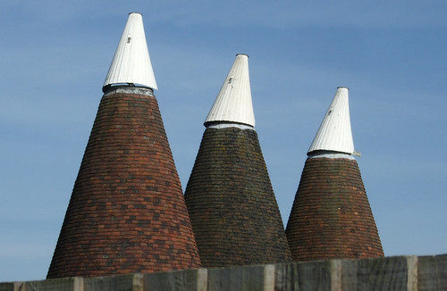
Between them we cross the A20, the old turnpike road from London to the Kent ports, now robbed of its long distance function by the M20 but still busy; and briefly parallel, then cross, the Maidstone East railway line, opened by the London, Chatham and Dover Railway in 1874. A fine line of three oast houses sprouts above a fence. On another gold course, belying my prejudice, a golfer helpfully and politely directs me to the footpath when I veer slightly off course.
The next woodland, Platt Wood, turns out to be a rich, atmospheric, park-like place where broadleaf trees mix with rhodedendrons and pine -- the result of deliberate planting in ancient Wealden woodland when it was part of the Great Comp Estate. The wood, which also contains a former clay working called Potters Hole, was threatened with development after World War II and then rescued by the local authority following a campaign. As the interpretation boards tell you, it's now managed by a parish council-led committee with help from the Forestry Commission. Entering the wood, we rejoin a very short section of the Wealdway, soon parting from it for the last time as it heads definitely south, while we slowly start to bend west.
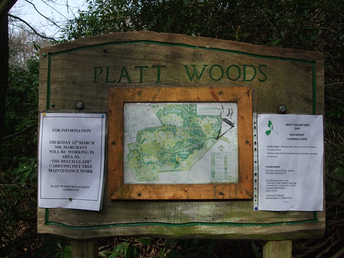
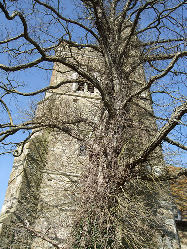
The woodland path suddenly emerges in the churchyard of the rather imposing St Mary's Church, Platt, actually a Victorian-era structure built in 1843 to save the expanding local population from travelling to Wrotham. Here I encounter a cat warming its bottom on a redundant stone stile that looks like it would be more at home in the moorlands of northern England. Opposite the church in Platt village, a notice board and leaflet dispenser explains some waymarking that's puzzled me for the last couple of kilometres -- the local WI have waymarked and promoted several circular walks round Platt as part of a community challenge project. On the edge of Platt, past more chocolate box cottages, a fine bridleway continues west, emerging finally on Crouch Lane, just south of Borough Green, where the next section of the Countryway heads off down a farm track at a junction where farm signs vie for tree space.
A sufficient walk for one day, so I head up Crouch Lane into Borough Green, a large roadside village, bordering on a small town, where the old road from Gravesend to Hastings crossed an east-west turnpike following a line south of the Downs from Guildford to Maidstone: the latter is now the A25, a road perhaps best known for sharing its number with London's orbital motorway, an early section of which parallels it. Here I meet up again with the Maidstone East line and head back towards London. Chesterton describes Borough Green as "workmanlike"; it's certainly the most urban environment I've been in since catching the train earlier, and the trappings of civilisation -- such as the seven-days-a-week late opening Coop supermarket next to the station -- certainly work for me.
View a map http://maps.google.co.uk/maps/ms?ie=UTF8&hl=en&msa=0&msid=117966169375523396049.00046414d40d8252e7b70&ll=51.414197,0.368729&spn=0.106206,0.219727&t=h&z=12
Route description pdf
More information
- Kent County Council walking http://www.kent.gov.uk/leisure-and-culture/explore-kent/walking/
- Visit Kent http://www.visitkent.co.uk/
- Gravesham Borough Council http://www.gravesham.gov.uk/
- Visit Gravesham http://www.gravesham.gov.uk/index.cfm?articleid=38
- Wealdway http://www.kent.gov.uk/leisure-and-culture/explore-kent/walking/wealdway-walk.htm
- Gravesend Tourist Information Centre http://www.gravesham.gov.uk/index.cfm?articleid=2554
- Cobham Parish Council (includes Sole Street) http://www.cobham-kent-pc.gov.uk/
- London's Geology (Story of London) http://www.storyoflondon.com/modules.php?op=modload&name=News&file=article&sid=348
- Geology of London (Wikipedia) http://en.wikipedia.org/wiki/Geology_of_London
- London Basin (Wikipedia) http://en.wikipedia.org/wiki/London_Basin
- Kent Geology (Kent RIGS) http://www.kentrigs.org.uk/kentgeo.html
- England's Geology: Greater London (Natural England) http://www.english-nature.org.uk/Special/geological/sites/area_ID14.asp
- National Association for Areas of Outstanding Natural Beauty http://www.aonb.org.uk/
- Kent Downs AONB http://www.kentdowns.org.uk/
- K-LIS (Kent Landscape Information System) http://www.kent.gov.uk/klis
- Cock Inn, Luddesdown http://www.cockluddesdowne.com/
- Meopham Parish Council http://www.meopham.org/
- Meopham & District Footpaths Group weblog http://www.meopham.org/information.php?Section=Blog
- Harvel (Wikipedia) http://en.wikipedia.org/wiki/Harvel
- Coppicing (Wikipedia) http://en.wikipedia.org/wiki/Coppicing
- Tonbridge & Malling Borough Council http://www.tmbc.gov.uk/
- Visit Heart of Kent http://www.visitheartofkent.com/
- Pilgrim's Way (Wikipedia) http://en.wikipedia.org/wiki/Pilgrim%27s_Way
- North Downs Way National Trail http://www.nationaltrail.co.uk/northdowns/
- European Path E2 http://www.ramblers.org.uk/info/paths/name/e/e2.htm
- Trottiscliffe Village http://www.trottiscliffevillage.co.uk/
- Trosley Country Park http://www.kent.gov.uk/leisure-and-culture/explore-kent/parks-and-open-spaces/trosley-country-park.htm
- National Trust http://www.nationaltrust.org.uk/
- Coldrum Longbarrow (National Trust) http://www.nationaltrust.org.uk/main/w-global/w-localtoyou/w-south_east/w-south_east-countryside/w-south_east-places-north_kent/w-south_east-places-north_kent-coldrum_longbarrow_wrotham_water.htm
- M20 (Wikipedia) http://en.wikipedia.org/wiki/M20_motorway
- E15 (Wikipedia) http://en.wikipedia.org/wiki/European_route_E15
- Addington Parish Council http://www.addington-parish.org.uk/
- Angel Inn, Addington Green http://www.theangelinnaddington.co.uk/
- Seekers Trust http://www.ademo.co.uk/seekers/
- A20 (Wikipedia) http://en.wikipedia.org/wiki/A20_road
- Maidstone East railway line http://en.wikipedia.org/wiki/Maidstone_East_Line
- Platt Parish Council http://www.plattpc.kentparishes.gov.uk/
- Platt Woods http://www.plattpc.kentparishes.gov.uk/default.cfm?pid=3611
- St Mary's, Platt http://www.stmarysplattchurch.org.uk/
- A25 (Wikipedia) http://en.wikipedia.org/wiki/A25_road
- Borough Green Parish Council http://www.boroughgreen.gov.uk/


4 comments:
Well written post. I walked part of your route on Friday along the Wealdway from Gravesend as far as Wrotham Heath on the A20.
People were still sitting on top of Coldrum having a picnic!
Glen
Sheltz and I did this section on Thursday (5 July), and enjoyed it tremendously for the most part - much woodland walking in the earlier part, with an interesting sojourn at Coldrum Longbarrow for lunch (trying to ignore the pretty ribbons). The latter part, across golf courses much of the time, was enjoyable enough. However, a warning's due, and an alternative route suggestion, for one short section. After crossing the A20 at the far side of West Malling golf course, we entered the orchard (exit golf course, turn R onto A20, walk for 100 paces or so then L into orchard at fingerpost, half-hidden in trees). The orchard is severely neglected - possibly abandoned - and is thoroughly overgrown, at first with grass/undergrowth, then with profuse nettles. We managed to hack a way through the nettles, the line of the path still faintly visible, until reaching the gate into the field to our left. The gate itself needed hacking at just to be able to open it, as did the second gate, halfway across the two fields. At the far side, we turned R and walked up parallel to the railway, only to find the way blocked by tall metal fencing. This ran across the route/path and down the railway fencing - luckily there was a narrow gap between the two fences, just as badly overgrown, and we hacked our way up to the Aldon Lane bridge over the railway. This, along with multiple metal cages holding snarling, barking, vicious-looking fighting dogs by the fenced area, made the whole section a very unpleasant experience. I'd certainly recommend finding an alternative way to the railway bridge from the golf course - the obvious way is to turn R off golf course onto A20 (possibly keeping inside line of trees on golf course - the road is fast and busy), then down to where Aldon Lane comes off L (about a quarter-mile) and up to bridge to rejoin route.
Apart from this latter section, a fine and rewarding segment of the LCW walk, much recommended.
Hi Dog-Whisperer and thanks for this. I actually rewalked this section myself very recently but I haven't had time to revise it. I found exactly the problem you stated, which is a shame as for all kinds of reasons it would good to have that orchard on the route. The alternative, which I'll be describing in a future update, is to continue right (west) along London Road (A20) and take the first left along Aldon Lane to the railway line where the old route rejoins. It's all road walking but it doesn't add that much extra road, there's a good footway along the A20 and Aldon Lane is very quiet.
Further to the comments above, please note I've now provided a revised and updated description and commentary, avoiding among other issues the overgrown orchard mentioned in the comments above. See here: http://desdemoor.blogspot.com/2018/10/london-countryway-2-sole-street-borough.html
Post a Comment