
Sandy heaths and canal towpaths were notable features of the previous section of the London Countryway, but on today's walk they take joint centre stage -- almost all of the route is in the surroundings of one or the other, with brief interludes through fields and alongside a small airfield. The scale and extent of the heathland is particularly striking and if you don't know the area you'll no doubt be as surprised as I was -- what with this and the hills explored on previous sections, the Countryway is doing a sterling job of debunking Surrey's image as a land of leafy suburbia packed with commuting stockbrokers. Among other unexpected curiosities are a lump of masonry that claims to be part of Waterloo Bridge and a near-century old Islamic cemetery that testifies to the long history of British multiculturalism. The Countryway also prepares to say goodbye to Surrey today, and ventures out of the county near the very end.
A short stroll from West Byfleet station, across an underutilised urban green space, the road peters out into a carpark and a footpath crosses a ditch where the route leaves the borough of Woking and enters, briefly, the borough of Runnymede. A few short steps further is the towpath of the Basingstoke Canal, where the picturesque ivy-clad lock keeper's cottage stands guard on Woodham Lock No 3, one of a six-strong flight of locks between here and Weybridge. This is an environment much changed since Keith Chesterton published his last edition of the London Countryway guidebook in 1981 -- the canal was then derelict and largely unnavigable although the early stages of its restoration were already underway.
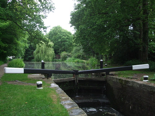
The canal was opened in 1794 from Basingstoke to the Wey Navigation as a way of transporting timber and agricultural goods from Hampshire to London, with coal and manure moving in the other direction via the Wey and the Thames. It was only ever a moderate success and first went into receivership in the 1850s following competition from the railway. One of a number of minor waterways not nationalised in 1949 as what later became the British Waterways network, by the 1960s it was still in private hands but in an advanced state of overgrowth and dereliction, and some sections had even been built on, though various lengths of the towpath were still popular with walkers. The lack of maintenance was causing flooding problems for nearby homeowners in some places and there were even proposals to fill the whole thing in.
Then in 1966 local people formed the Surrey & Hampshire Canal Society to campaign for its restoration and ten years later they were successful in persuading the two county councils involved to acquire the canal by compulsory purchase. The restoration resulted in the 51km between the Wey and the Greywell Tunnel at North Wanborough officially reopening throughout to navigation in 1991 -- a remarkable achievement for a workforce comprised entirely on volunteers, as is evident from comparing "before" photos, including one in Chesterton's book, with what's there today. The Society still aspires to reopen the final 8km into the centre of Basingstoke but the tunnel itself and later buildings and motorways obstructing parts of the route have limited progress. The reopened canal is now managed by the Basingstoke Canal Authority, set up by the county councils, and the whole length is designated a Site of Special Scientific Interest (SSSI).
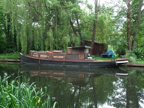
Like most canals through built-up areas, the stretch I'm on has that odd feeling of separation from its surroundings, a sort of parallel geography from a zone where time moves at a different rate, imposed on the everyday framework of streets and paths. Back in 1981 Chesterton found a "decaying charm" in the dereliction, with "water lilies, swans, rusted bikes and oil drums all together on one shallow patch of water." Such scenes are now long gone, and perhaps they are a loss of sorts, but the canal still has the feel of a quiet backwater -- it's a lesser-used waterway for navigation with sections of it sometimes closed to conserve water, and with waterside patches of reeds and vegetation it sometimes seems like a long, thin pond. It's a while before I encounter my first moored boat, the White Heather, a utilitarian narrowboat with a name plate that announces it is registered in the Borough of Marylebone -- a London local authority that encompassed the head of navigation of the Grand Union Canal at Paddington but which has been defunct since 1965 when it merged with the City of Westminster. Later two moving boats, the Puffin and the Pluto, pass me in succession. Far more people are using the towpath on this May bank holiday, mainly walkers and runners, with few cyclists in evidence.
The route passes three more locks, at the last of which the towpath crosses back into Woking borough, and threads under Sheerwater Bridge. This area, Sheerwater, is a large residential estate of 1,300 homes built by the London County Council in the 1950s as infill between West Byfleet and Woking, replenishing housing stock lost in the Blitz of World War II. I'll be saying a lot more about the LCC, founded as the first proper unified municipal authority for the metropolis in 1889 and superceded by the much bigger Greater London Council in 1965, but it's interesting to note that, like the much older City of London Corporation, the council exercised an influence way beyond its own boundaries, into areas that were already in practice the outer orbits of the capital, although still officially separate even today. The influx of inner city Londoners was unwelcome locally, especially when the newcomers returned Labour and even Communist members to a formerly solidly Conservative local council.
From the towpath, buffered by strips of straggly woodland, you see little of the housing development, and a while after Sheerwater Bridge there's open green space beyond the trees -- Sheerwater Recreation Ground, part of the original community layout, with a play areas, playing fields and an athletics track. Opposite, across the canal, the gardens of better-appointed houses stretch down to the waterside, with willows and wooden gazebos. It's a fair stretch of over 3km along the canal, at a good pace along the straight, flat and well-surfaced path, before finally reaching Monument Bridge on the edge of Woking.
When the canal was first built, this whole area was a huge heathy common, once part of Windsor Great Park which was originally far greater in extent, but by the 18th century in the hands of the earl of Onslow, who was determined to protect the common and not let it fall to enclosure. Two things in particular changed that situation. One was the opening of the London and South Western Railway from Vauxhall to Woking Heath in 1838, and its later extension to Basingstoke and Southampton. The other was the London Necropolis & National Mausoleum Company's project for a vast cemetery with its own dedicated rail service to London in the 1850s, on land compulsorily purchased from the Onslow family. Both have already been discussed at the end of the previous section as they also affected West Byfleet. In the event the Necropolis Company bought much more land than it needed -- only the first stage of its plans, the 162ha Brookwood Cemetery, was completed, and the surplus land was eventually sold to private developers who built a town of the living rather than a city of the dead.
Or, as some would have it, the partly living, as Woking is pretty much the paradigm case of the soulless English commuter town -- 'A Town Called Malice' as Paul Weller, who grew up here in Stanley Road, put it, where:
Rows and rows of disused milk floatsIn the same song, Weller alludes to the Necropolis Railway: "The ghost of a steam train / echoes down my track. / It's at the moment bound for nowhere." Weller himself, of course, was bound for somewhere -- London itself was luckily just down his track and he's very much a London writer, though notably with the particular sensibility borne of a youth driven by creativity crushed in the capital's outer shell of net curtain-twitching suburbia.
Stand dying in the dairy yard
And a hundred lonely housewives
Clutch empty milk bottles to their hearts.
The Countryway doesn't quite wander into Woking proper, but instead crosses the bridge north towards Horsell Common, where an information board leads me to a curiosity only a few steps off the route not included in Chesterton's guide. Hidden in the trees just northeast of Monument Bridge is the Muslim Burial Ground, built in 1917 for the bodies of Muslim soldiers from Indian regiments who died in special hospitals on England's south coast after being injured on the Western Front during World War I. The War Office commissioned the work in response to rumours that the armed forces hadn't been conducting proper Islamic ceremonies. There were more burials during World War II, but the site was later neglected and the graves were removed to the military section of Brookwood Cemetery in the 1960s. The gateway and courtyard remain, built in a prosaically English interpretation of Islamic style.

It's strange to read the list of Shahs and Khans and reflect on the strange currents of history that brought these men from places like the Punjab through what's still the bloodiest conflict in human history to a last resting place in a Surrey wood. It's also a demonstration that British multiculturalism goes back far beyond the mass immigrations of the post-World War II age -- one reason the burial ground was located here was the proximity of Woking's Shah Jehan Mosque, built in 1889 as the earliest purpose-built mosque in the UK.
An appeal is currently underway to restore the remaining structure. It could begin by removing the disgraceful National Front logo that is currently defacing a plaque on the main gate. I guess those responsible for the grafitti would be too stupid and hateful to recognise the irony that the people originally buried here gave their lives fighting a war for the British Empire.
The use of this area as a burial place stretches back much further than World War I. Just behind the car park near the Muslim Burial Ground, the uneven ground is in fact a 4,000-year-old bell barrow, used for interring the remains of tribal leaders. On the opposite side of Monument Road, if you take the first footpath west (as I first did by mistake), you'll cross a heathy open area with two further barrows, a bell and a disc, types that are unusual in Surrey. The bronze age people who built these were initially responsible for clearing the trees and exhausting the sandy, acidic soil by arable farming, creating the heaths that are such a characteristic feature of today's walk.
Horsell Common is unusual among public commons in that, along with most other large public open spaces in Woking, it is not owned by a council or a big institution like the National Trust but by a private charity, the Horsell Common Preservation Society. As previously mentioned, the Onslow family ended up owning the extensive common land hereabouts and resisted its enclosure and development -- today's Horsell and Pyrford commons are the legacy of this. By the early 20th century the Onslows were finding management responsibilities a burden so passed them to a trustee management board, which later became an independent membership society that in 1966 finally purchased the land freehold at £1 an acre. The common has since been designated an SSSI and a European Special Protection Area (SPA) for its bird life. Rather pleasingly, the Society still retains a vestige of old common rights by granting wood licenses allowing people to pick up fallen wood for personal use.
The common is also celebrated as the landing place of the "shooting star" that turns out to be the vanguard of a Martian invasion in HG Wells' The War of the Worlds (1898). Ogilvy rides out to find it on an "early morning [that] was wonderfully still, and the sun, just clearing the pine trees towards Weybridge, was already warm...Find it he did, soon after dawn, and not far from the sand pits. An enormous hole had been made by the impact of the projectile, and the sand and gravel had been flung violently in every direction over the heath, forming heaps visible a mile and a half away. The heather was on fire eastward, and a thin blue smoke rose against the dawn. The Thing itself lay almost entirely buried in sand, amidst the scattered splinters of a fir tree it had shivered to fragments in its descent. The uncovered part had the appearance of a huge cylinder, caked over and its outline softened by a thick scaly dun-coloured incrustation."
Bromley-born Wells was another creative smalltown boy who suffered a stultifying childhood and no doubt took great delight in wishing murderous heat ray-toting Martians on the worthies of Woking, though they might have proved marginally more welcome that the Communist-voting Cockneys of Sheerwater.
The route passes mainly through wooded sections of the common, which initially has a very urban feel, criss-crossed by busy roads. For a while it follows Carlton Road, an unadopted private road with sizeable houses looking out on the edge of the woodland. One of them is an early 20th century house in an odd-looking jumble of styles, surmounted by an extravagant cupola, which houses the 50-year-old Tante Marie cookery school, now part owned by foul-mouthed celebrity chef Gordon Ramsay. After crossing the A245 and passing the last bus stop on the route until the end, the noise of the traffic soon fades.

The quiet path runs through birch and scented Scots pine and along the edge of more open, heathy areas, then picks up a fine old bridleway through a spindly arm of woodland jutting northwards from the bulk of the common.
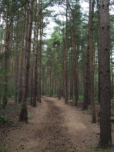
Here there are green meadows to the left known as Bourne Fields, a recent acquisition of the Preservation Society who were keen to create an additional buffer to the common proper. The river Bourne, on the opposite boundary of the meadow, is one of those tautological names which, like the river Avon, means "the river River", as 'bourne', cognate with Scottish and Northern English 'burn', is from an Anglo-Saxon word for a small river or stream. This particular river River rises in heathland southwest of here and flows by a circuitous route to the Thames near Weybridge. I soon cross it on a fine wooden footbridge, where it marks the boundary between Woking and Surrey Heath boroughs and the northern limit of Horsell Common.

The bridleway continues ahead, now running along the western boundary of a grassy airfield used by private light aircraft, flying schools and police helicopters which names itself, with some overstatement, Fairoaks Airport (FRK). Flying is supposed to have started here in 1931 when it was still a farm, then the land was requisitioned by the Air Ministry in 1936 to use as an RAF training school. It passed into private hands, still with a grass runway, in 1967 and there was much wrangling in the late 1970s over planning permission for the present tarmac runway. The approaches to the runway are right over the bridleway, giving rise to the rather incongruous site of full-sized Low Flying Aircraft triangular warning signs on a leafy rural path.

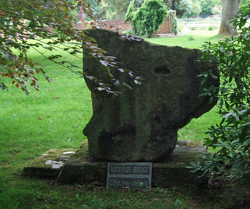
Crossing the A319 Chertsey Road, the route climbs wooded Stanners Hill, once part of the nearby Ottershaw Park estate -- it still appears to be in private ownership, although it's open as access land. The bridleway approaches the woodland along a residential drive where, in the garden of Stanyards Farm to the right, is a lump of granite masonry labelled "Waterloo Bridge -- a chip off the old block". I presume it's claiming to be a fragment of the original 1810 bridge across the Thames. When this was replaced by the current bridge in the 1940s, lumps of it were distributed as far afield as New Zealand, so it's conceivable one found its way to Chobham.
On the other side of the hill, by a junction with the wonderfully named Gracious Pond Road (probably a corruption of a proper name, Cratchett's Pond), the route comes within a few metres of, but does not cross, the boundary with Runnymede borough, its evocative name, forever associated with one of the better known incidents of English history, indicating our increasing proximity to the river Thames. Instead I enter for the first time the boundary of Chobham Common, crossing a southeastern protrusion of it along the side of an open, heathy area where the soft sand underfoot is heavy going for a while. Through the woods on the other side the route crosses farmland, or, rather, equestrian land, rounding the edge of a wood where a row of horse boxes is tucked just inside the trees. Another fine bridge then leads across farm tracks and across another road.
Keeping up the equestrian theme, the route then heads of the drive of Langshot Stud Farm and starts to circumnavigate the farm, before a yellow footpath waymark sends me off through woods on the right and into the common proper. This path is rough and hard to follow, partly as it's blocked by a large fallen gorse bush, and then you're picking your way on rough ground on the open common to gain the main track. It's a relatively short section but if I was rewriting the route from scratch I'd find an alternative that's more straightforward: some are obvious from the map.
These difficulties will soon be forgotten, however, once you find yourself on the fine main track across the common. If you've never been here before, you'll be as astonished as I was that such an extensive and wild open space can be found in the Home Counties within an hour's journey of the capital. All around stretches a rugged, undulating surface of dirty sand dotted with gorse, bracken, lone stubby trees, still gloomy ponds, bogs and tight dark patches of woodland, the only built structures within sight the lines of gaunt electricity pylons which somehow emphasise rather than shrink the scale of the place.

Yes, as I explained in the previous section, heathland is the result of human management, but this feels very much the kingdom of nature and more than a little lonely and desolate, a rare quality in such a populated area, though sections of some of the bigger open spaces closer in such as Richmond Park and Epping Forest can almost achieve the illusion. It could almost be a brown moorland of England's Pennine north, and indeed has often played that role for the benefit of London-based film crews saving on travelling time -- many a grim-faced TV detective has prodded a grisly fake corpse from its shallow grave here to a soundtrack of portentous strings.
At over 574ha -- almost 6 km2 -- Chobham Common is the biggest remaining heath in Surrey, the largest National Nature Reserve (NNR) in southeast England and, according to its managers, Surrey Wildlife Trust, "one of the finest remaining examples of lowland heath in the world". Like Horsell Common, the site was once part of the wastes of Windsor Great Park, the still-extensive area of which we're due to cross in our next section. As with Horsell, it later belonged to the Earl of Onslow, whose family sold it to the council for £1 in 1966. In wildlife circles it's particularly famed for its invertebrates such as spiders and ladybirds, but also birds, snakes, amphibians and one of the UK's biggest colonies of water voles. There are self-guided trails around the site and a walking leaflet is downloadable from the Wildlife Trust website.
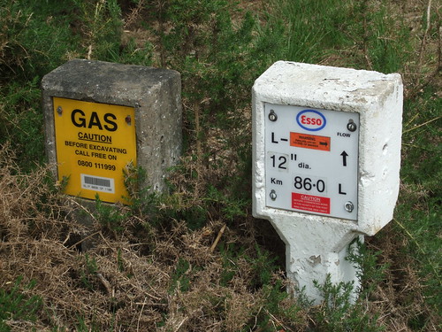
My route is now straightforward for the rest of the section, following the broad main track northwest across the common, presumably a former carriage drive -- curiously the first section of this is not a public right of way but is of course open under the general public access policy of the site. I spot markers just off the path to the right indicating the passage of oil and gas pipeliens.
The path climbs Staple Hill, emerges between huge boulders on a lane and enters a car park that's currently out of use, although it was one of the first two car parks to open on the common, back in 1936, catering for the growing demand for car-based leisure access. From the hillock to the east of the car park is a breathtakingly extensive view of rolling open country, interrupted only by the M3 motorway in the dip below.
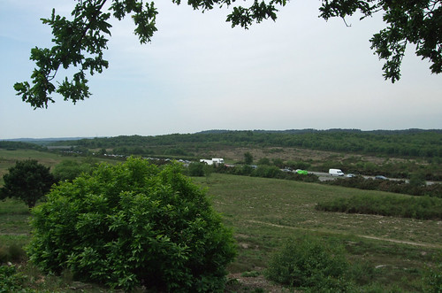
This area once suffered badly from summer fires, but is now managed with more effective fire prevention techniques since a particularly destructive series of fires in the 1970s. From here you can look across to the northeast corner of the common, site of the former Longcross Defence Evaluation and Research Agency facility where the Ministry of Defence once used to test tanks and other military vehicles -- this is now in the hands of a private defence technology company, QinetiQ, who make a supplementary income out of it by renting it to film crews.
The M3, the first single digit radial motorway we've so far crossed, links London and Southampton, opening in stages from the 1970s to relieve traffic on the A30, a road we'll reach right at the end of this section. This was the second stage, opened in 1974. I cross under it in a damp and spooky subway, its green lichened walls lit by thick glass skylights through to the carriageway above. I wonder how long it's been since someone stood there and looked down.

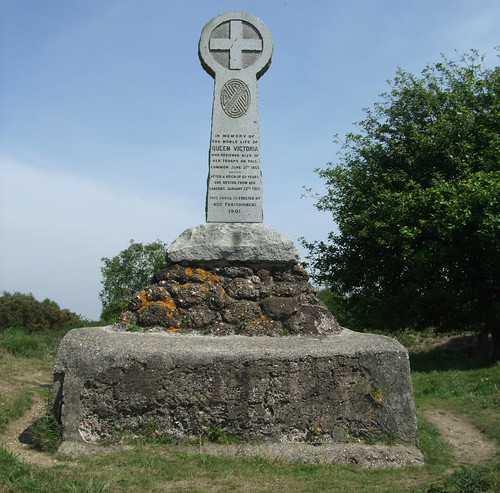
Beyond the motorway the path, now a bridleway, continues in more-or-less the same direction, still across open heath, crossing the minor B386 road and passing one of the common's few significant built structures. The Queen Victoria Monument, looking perhaps unintentionally like a Celtic cross, was erected on the queen's death in 1901. This site was chosen as it was where Victoria had reviewed a gathering of troops in 1853 prior to their being sent off to the Crimea, including the notorious Light Brigade. The weather was appalling and the dire conditions of this temporary encampment led to the Army developing Aldershot, not far west of here, as a permanent base.
After the monument the path descends to follow a woodland edge until it's forced left by the railway, a branch of the London and South Western Railway opened between Staines and Ascot in 1856 and one of the earlier British main line railways to be third rail electrified, in 1916. Finally I leave the common and emerge on Chobham Road just on the other side of the railway bridge from Sunningdale, a large, sprawling village, parts of which are also known as Broomhall. Passing through the gate from the common I leave the administrative area of Surrey, the county through which I've been walking for six sections of the Countryway, although I'll be making a brief return in the next section. What's less clear is which county I enter.
As the maps in the 1981 London Countryway guide show, this whole section was then entirely within Surrey. But part of Sunningdale fell into Berkshire, the boundary crossing the railway just west of the station where we finish this walk. And while most of Surrey's portion of the village was within Surrey Heath, some of the northeast fell into Runnymede, a case of more recent development around a railway station failing to align with administrative boundaries dating back centuries and a challenge for effective local government.
Then, towards the end of the 1980s, the Conservative government set about their grand plan to restructure the existing two-tier system of local government in the UK, with powers split between larger County (or in Scotland, Regional) councils and smaller District or Borough councils, restructuring them into a single tier of unitary authorities. This policy has been widely interpreted as motivated by a desire to strengthen the power of central government by making it more difficult for influential local power blocs to develop, as had happened in London where the Greater London Council led by Ken Livingstone has been a constant thorn in the side of prime minister Margaret Thatcher (two characters we will undoubtedly encounter again). The government first abolished the GLC, then the other "Metropolitan Counties" in England's big cities, their powers cascading to their constituent boroughs, then, clearly having gained a taste for the Balkanising bug, applied the same principles to Scotland and Wales and began on non-metropolitan England. Here, however, the process was piecemeal, beginning mainly with excising middle-sized cities from their surrounding counties, and rapidly stalling thereafter. Oddly, the only historic county to be dismembered completely in this tranche was the true blue Tory Royal County of Berkshire, which was split into six unitaries in 1996. It wasn't until 2009 that further unitaries were created, and Cheshire and Bedfordshire have followed Berkshire into administrative oblivion.
Back in Sunningdale, the 1996 reorganisation saw some judicious boundary tweaking which, following a controversial consultation, saw the whole village incorporated into the new unitary incarnation of the Royal Borough of Windsor and Maidenhead. Which leaves the question of which county our little section is in -- while the bulk of Windsor and Maidenhead was once Berkshire, and it's convenient to group those six unitaries as Berkshire still, thus its listing on the keywords for this entry, none of this section was in Berkshire when that county still existed. Of course if you're a sign-defacing supporter of the Association of British Counties who believes that such boundaries have an immutable power linking blood to land, then there's no problem -- if Edward I would have called it Surrey, then Surrey it is.
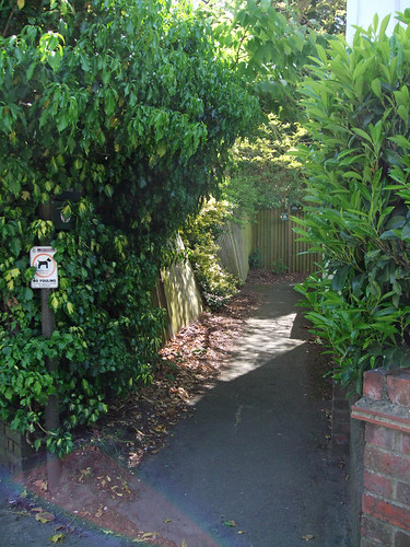
On the other side of the railway, the Countryway turns down Onslow Road, a final tip of the hat to the landowning family who preserved much of the countryside I've just walked through. Chesterton describes a station link that simply follows roads, but a more interesting alternative is along an old footpath, Halfpenny Lane, that threads between the backs of houses to emerge on the A30 nearer the station.
The A30, or Great South West Road, is historically one of London's most important arterial links and, at 457km, Britain's third longest A-road, reaching from London, or to be more precise Hounslow where it leaves the A4, about as far west as you can go to Land's End in Cornwall. Unlike a number of other key radial routes, however, it's been superceded by parallel roads like the M3 and the A303 rather than upgraded on its traditional alignment, and only about half the route is now part of the strategic trunk network. Through Sunningdale it still passes along a high street where a level crossing still intermittently interrupts traffic flow, though it's busy enough to cause you to rue the absence of a conveniently placed controlled pedestrian crossing with which to reach the station.

Sunningdale station is a modest structure with the feel of a temporary building, plastered with signs that welcome you to the "Home of the National School of Government" -- the main training centre for Britain's beaureaucrats, formerly known as the Civil Service College, which occupies a fine Neo-Classical mansion some distance northwest of the station, not far from John Lennon's former house, the equally well-appointed Tittenhurst. Railway companies must make a bit of extra cash from this kind of station branding, but, like the even more ridiculous branded roundabouts, their customers rarely seem to get more exciting than training colleges, insurance companies and call centres. "Welcome to Sunningdale, Gateway to Chobham Common National Nature Reserve" would have a much more alluring ring.
View a maphttp://maps.google.co.uk/maps/ms?ie=UTF8&hl=en&oe=UTF8&msa=0&msid=117966169375523396049.00046414d40d8252e7b70&num=200&start=73&z=11
Route description pdf
More information
- Surrey County Council http://www.surrey.gov.uk
- Surrey Countryside http://www.surreycc.gov.uk/countryside
- Surrey Interactive Maps http://surreymaps.surreycc.gov.uk/
- Surrey Walking (John Harris) http://www.walkinginsurrey.co.uk/
- Visit Surrey http://www.visitsurrey.com/
- Exploring Surrey's Past http://www.exploringsurreyspast.org.uk
- Woking Borough Council http://www.woking.gov.uk/
- Woking Green Spaces http://www.woking.gov.uk/leisure/greenspaces
- Visiting Woking http://www.woking.gov.uk/woking/visit/
- West Byfleet (Woking council) http://www.woking.gov.uk/council/planning/localplan/westbyfleet
- Byfleet Heritage Society http://www.geocities.com/byfleetuk/
- West Byfleet station (Wikipedia) http://en.wikipedia.org/wiki/West_Byfleet_railway_station
- South Western Main Line (Wikipedia) http://en.wikipedia.org/wiki/South_Western_Main_Line
- Basingstoke Canal Authority http://www.basingstoke-canal.co.uk/
- Surrey & Hampshire Canal Society http://www.basingstoke-canal.org.uk/
- Runnymede Borough Council http://www.runnymede.gov.uk
- Runnymede Parks, Gardens and Walks http://www.runnymede.gov.uk/portal/site/runnymede/menuitem.58d4f989924165a4f289e71030008a0c/
- Horsell Common Preservation Society http://www.horsellcommon.co.uk/
- Muslim Burial Ground (Horsell Common PS) http://www.horsellcommon.co.uk/musilim_burial_ground.php
- Tante Marie School of Cookery http://www.tantemarie.co.uk
- Surrey Heath Borough Council http://www.surreyheath.gov.uk
- Surrey Health Parks and Recreation Areas http://www.surreyheath.gov.uk/leisure/parksandrecreationareas/
- Fairoaks Airport (Alan Mann Group) http://www.alanmann.co.uk
- Chobham http://www.chobham.net/
- Surrey Wildlife Trust http://www.surreywildlifetrust.co.uk/
- Our Places - Surrey Wildlife Trust (Chobham Common) http://www.surreywildlifetrust.co.uk/Default.asp?EntityID={E6649CB3-2A6E-428D-BCE1-2D309F16379B}
- M3 (Wikipedia) http://en.wikipedia.org/wiki/M3_motorway
- Royal Borough of Windsor and Maidenhead http://www.rbwm.gov.uk/
- Windsor Tourism http://www.windsor.gov.uk
- Windsor Parks and Open Spaces http://www.rbwm.gov.uk/web/parks_openspaces.htm
- Windsor Public Rights of Way http://www.rbwm.gov.uk/web/prow_index.htm
- Sunningdale Parish Council (including walks) http://www.sunningdale-pc.org.uk/
- Waterloo to Reading Line (Wikipedia) http://en.wikipedia.org/wiki/Waterloo_to_Reading_line
- A30 (Wikipedia) http://en.wikipedia.org/wiki/A30_road
- National School of Government http://www.nationalschool.gov.uk


4 comments:
I walked this section today, Sunday 19th November 2017. The Muslim burial ground has been renovated recently and is now a well-tended and attractive "peace garden", well worth the slight detour to see it.
Most imporessed by the isolated feel of Chobham Common - it's the nearest thing I have seen in this part of the world to Rannoch Moor is Scotland, which I walked across in September.
I went up the rough path you describe from the equestrian centre to the Chobham Common track. It was no worse than many other paths, and I don't think that it needs to be picked out for a diversion. The fallen gorse bush you mention seems to have been removed.
There seems to be an orror in your directions in line 3 of page 3: "...go right through wooden barriers" should, I think, be "...go left..."
The Dog Whisperer and I walked this section on Wednesday 5th September as the next part of our circumnavigation of the whole route. It was most pleasant and we particularly enjoyed Chobham Common. The little path that runs behind houses approaching Sunningdale Station was a good alternative to the road too. You might (although possibly not) be interested to know that the level crossing at Sunningdale was designed by my brother-in-law some years ago and we were pleased to see it working so efficiently as we crossed the road. Thanks again for the informative description and commentary.
Greaat share
Thanks all!
Post a Comment