 |
| Ghost station: Crouch End on the Parkland Walk, Haringey. |
Following the hilly, semi-rural excursions of the
previous walk, this stretch of the Capital Ring uses well-defined paths often
following geographical features through largely flat surroundings. First, a disused
railway, the Parkland Walk, sweeps to Finsbury Park. The trail crosses the park
to pick up 17th century watercourse the New River through the newly
created Woodberry Wetlands, negotiates two attractive green spaces and a
historic street at Stoke Newington then descends through Springfield Park into
the Lea Valley, following the towpath along the river Lea and River Lee
Navigation through the bleak but curiously attractive and environmentally
valuable marshes of the Lea Valley Park. It ends at the recently regenerated industrial
area of Hackney Wick on the edge of the Queen Elizabeth Olympic Park, within
sight of the Olympic stadium.
This post covers two consecutive official Ring sections
combined to create a day walk. One ends and the other begins near Stoke
Newington station, but there are plenty of other transport options, including
easy links to six other stations as well as frequent bus stops.
Highgate
Highgate is one of London’s best known ‘villages’,
though except for its woods, crossed in the last section, the Capital Ring
misses its best-known features: the picturesque village green and the famous
cemetery are both some way off route. A tollgate on the Great North Road once
stood by the green, still commemorated by the landmark Gatehouse pub, now a
1930s Brewer’s Tudor building but at a location that’s housed an inn since at
least the 16th century.
Folk etymology holds that the place name simply refers to
this ‘high gate’ atop the prominent 100 m hill, but the first syllable is from
Old English hæg, ‘hedge’. As described in the previous section, much of
the land in this part of London, in the former parishes of Finchley and
Hornsey, was part of the Bishops of London’s estate, and in mediaeval times the
bishops’ hunting park, Hornsey Great Park, carved from the ancient Forest of
Middlesex, occupied a swathe of it. The southeastern edge of this park elbowed
along Hampstead Lane and Southwood Lane, and close to the corner, on the
plateau atop the hill, there was a gate in the high hedge surrounding the episcopal
domain. Hampstead Lane also marked the parish boundary of Hornsey to the north
and St Pancras to the south, and central Highgate today is still divided along
the same line between the boroughs of Haringey and Camden.
As early as 1318, the bishops were levying tolls at the
gate for the use of tracks through the park linking to the Spaniards Inn on
Hampstead Heath to the west and the White Lion at East End (now East Finchley)
to the north. By the end of the century, the track towards East End, today’s North
Hill, had become part of A1 predecessor the Great North Road, from the City of
London along Holloway Road, up Highgate Hill and on to York and Edinburgh, as
also discussed in the previous section. Activity around the junction intensified,
initially to provide services for road users, and by the following century Highgate
was an established settlement, already attracting wealthy residents for its
combination of an airy and picturesque location and convenient links to central
London.
The second major turning point in Highgate’s development
into the wealthy and exclusive ‘village’ of today was, ironically, the loss of
the main road that had created it in the first place. As road traffic developed
in the 18th century, horse-drawn vehicles became larger, heavier and
less able to cope with the steep climb up Highgate Hill. A turnpike trust was
set up in 1810 to address this problem by building a bypass slightly to the
east, partly in tunnel to ease the gradient. The tunnel collapsed during
construction and was replaced by an open cutting, with a tall arched brick bridge
designed by John Nash to take Hornsey Lane across it. Opened in 1813, the new
road was soon known as the Archway after the bridge, and today is called
Archway Road.
Soon after opening, its gravel surface was replaced by
engineer Thomas Telford with a novel hard covering made from gravel bonded with
concrete, now regarded as one of the first modern road surfaces. Nash’s bridge
was replaced in 1900 with the current crossing designed by Alexander Binnie, an
elegant cast iron structure that has an unfortunate reputation as a suicide
hotspot. The diversion of through traffic left the village as a sleepy
semi-rural retreat whose well-heeled residents were well-placed to resist the
tide of development in the late 19th and early 20th
centuries.
The steep path that climbs between the houses of Priory
Gardens at the back of Highgate station at first seems to herald a return to
the woodlands that closed the previous section, but the patch of trees known as
Highgate Spinney, to the right, has grown up over the northern portal of the
Highgate Tunnels, of which more later. Arriving on Shepherds Hill, just to the
left is the attractive mock-Tudor Highgate Library, purpose-built on a former
priory site in 1902: predictably, it’s been threatened with closure in recent
years but is supported by a vigorous Action Group.
Shepherds Hill leads to busy Archway Road, still the route of the A1 today: it ran largely through open country when first constructed but today has something of the character of an Edwardian high street. Opposite looms the Grade II-listed Gothic Revival hulk of Jacksons Lane Community Centre, built to designs by local architect W H Boney in 1905 as the Highgate Wesleyan Methodist Church. By the early 1970s it was disused and derelict, spurring a local campaign involving among others later deputy Mayor of London Nicky Gavron. It was reopened in 1975 as an arts and community centre which has helped nurture the talents of Eddie Izzard, Matt Lucas and David Walliams among others.
Efforts to save it from being demolished in the early 1980s so the A1
could be widened ultimately benefited the whole neighbourhood, which is now a
designated conservation area. Historic Highgate is southwest of here, across
the main road, but our route is south along it. You’ll have to continue a
little further past the Ring’s turnoff to admire the arch itself, but before
you head downhill, note the various entrances to Highgate station, one legacy
of the particularly complex history of railways in the area. As this has a
direct bearing on the character of our next stretch of path, we now need to
address it in detail.
The Northern Heights and the Parkland Walk
 |
| Looking in the 'up' (southeast) direction along the Parkland Walk at Highgate. |
London’s suburbs grew exponentially over the following
decades and services on the line rapidly became overcrowded. Some relief was
offered in 1907 when the nascent Underground system reached the area in the
form of the Charing Cross, Euston and Hampstead Railway (CCE&HR), a deep
level ‘Tube’ line from Charing Cross to Camden Town, with branches on to
Golders Green via Hampstead and to Highgate – or at least a station called
Highgate, since renamed Archway, some way south of the village at the bottom of
Highgate Hill. From here, passengers could be hauled uphill on a San Francisco-style
cable car along a street-based line which was later converted into part of London’s
original electric tram network, closed in the 1950s.
The CCE&HR was also promoted by an independent
company, but by the time it opened it was a subsidiary of the Underground
Electric Railways Company of London, also known as the Underground Group, the
enterprise created by flamboyant and unscrupulous US entrepreneur Charles
Yerkes which ended up owning most of the early Underground lines. In 1924 the Golders
Green branch was extended to a second station at Edgware, just to the north of
the terminus of the Finsbury Park line, which a couple of years previously had
become part of the London and North Eastern Railway (LNER) under the
government’s grouping scheme. Then in 1926, the CCE&HR was linked to the
City and South London Railway, opened in 1890 as the world’s first deep level
Tube, to create the Northern Line, with its distinctive parallel branches
through central London via Charing Cross or Bank.
The government unified control of most local passenger
transport in London in 1933 under the not-for-profit London Passenger Transport
Board, better known as London Transport, the earliest predecessor of today’s
Transport for London. Under the new regime, the Underground Group was integrated
with its arch-rival the Metropolitan Railway to create the London Underground. Two
years later, the Board announced its ambitious New Works programme for
expanding the network, intending both to build new stretches of Tube line and to
convert sections of existing surface rail branch lines to electrified metro-style
service.
Under the Northern Heights scheme, the Northern Line would
be extended from Archway in a new tunnel, with additional platforms at Highgate
underneath the LNER station, emerging south of East Finchley to join the LNER
branches to High Barnet and to Edgware via Mill Hill East, which would become
part of the Underground. The GNER station at Edgware would be closed, its lines
diverted through the existing Underground station and along a further extension
to Bushey Heath, where a major development was planned on a greenfield site. The
Great Northern and City Railway, an isolated section of the Underground between
Moorgate and Finsbury Park, built as a Tube but to main line proportions, would
be transferred from the Metropolitan Line to the Northern Line and joined to
the surface lines at Finsbury Park so Underground trains could continue via the
surface station at Highgate to Alexandra Palace on newly refurbished and
electrified tracks. The celebrated Underground architect Charles Holden designed
a rebuilt Highgate station integrating both high- and low-level platforms, with
grand entrances on Archway Road.
Work proceeded rapidly and by July 1939 Northern Line
trains were running through the new tunnel to East Finchley. But World War II
began only weeks later, significantly disrupting further progress. The new low-level
Highgate station opened early in 1941, soon after the line to High Barnet had
been converted to Underground use, and quickly found a dual role as a bomb
shelter. The high-level station was equipped with new platforms with concrete
canopies and a direct passageway to the Tube platforms, but little additional work
was completed. When the war ended in 1945, London Transport still intended to
complete the project, and the various conversions and extensions were even
shown as “under construction” on Tube maps, but the priority of repairing war
damage amid continuing shortages, the competing demands of a similar scheme for
the Central Line and an unhelpful shift of thinking on urban transport towards
buses and cars saw the remaining plans finally shelved in 1954.
So what’s left of the Northern Heights besides the current
Northern Line High Barnet branch? Electrification of the original Edgware
branch reached Mill Hill East in 1941, prioritised to serve a barracks there,
but got no further, leaving the curious stub of Northern Line familiar from
today’s network. Passenger services beyond this never restarted, though LNER
and its successor British Rail, the nationalised main line operator from 1948, continued
to convey freight to the old goods yard at Edgware until 1964. The station site
was subsequently redeveloped as a shopping centre but stretches of the line can
still be followed as footpaths.
Post-war Green Belt legislation aimed at containing
London’s sprawl stymied the Bushey Heath extension: today the proposed site of
the terminus is still a roundabout amid fields, passed on Loop 15 where
I’ve said a bit more about how far the work got. The tunnel from Moorgate
remained the disconnected Highbury ‘branch’ of the Northern Line. Following the
horrific Moorgate disaster in 1975, when a train overran the buffer stops and
crashed at full speed into the end of the tunnel, this section was handed over
to British Rail and finally joined to the main line, reopening in 1976 as part
of the suburban stopping service to Hertford and Welwyn Garden City, today
provided by privatised operator Govia Thameslink.
Most interesting for our purposes is the fate of the tracks
from Finsbury Park through Highgate to Alexandra Palace. GNER and then British
Rail continued to provide steam-hauled passenger trains, but the service was
half-hearted and irregular, cut back to a shuttle that didn’t continue through
to Kings Cross, suspended for a year due to coal shortages and then limited to
peak hours using older rolling stock. Unsurprisingly, ridership dropped
considerably: passengers contributed to the vicious circle of decline by switching
to buses and the fast and frequent Tube instead. Holden’s grand plan for
Highgate station was substantially pruned, with the escalator entrances from
Archway Road realised only as the modest sheds we see today.
Passenger services on the surface line were withdrawn
entirely in 1954, though freight continued to Muswell Hill until 1956 and to
Highgate until 1962 and London Underground used battery powered locomotives to
transfer empty Tube stock from Drayton Park to Highgate until 1970. As we saw
at the end of the previous section, the disused high-level platforms at
Highgate are still intact, partly used to house ventilation equipment for the
Tube station, and can be visited occasionally on guided tours.
The closure was bad news overall for London’s transport
network, notably leaving Muswell Hill as one of the few important outlying centres
without a rail connection. But it turned out to be very good news for walkers,
cyclists and nature lovers. By the early 1970s the tracks were lifted and
ownership transferred to Haringey and Islington councils, who were initially
keen to build houses on as much of the route as possible. But walkers were
already using parts of the trackbed unofficially, and a public campaign was
ultimately successful in securing the conversion of nearly the entire length into
a footpath, cycleway and London’s longest Local Nature Reserve. Following resurfacing
work and the installation of access points, it was officially reopened as the
Parkland Walk in 1984. The Walk is split into two sections, separated at
Highgate, with no access for safety reasons through the tunnels and along the cutting
around Highgate Woods (crossed by the Ring when it entered the woods in the
previous section).
The Parkland Walk has flourished despite occasional issues
with neglect and antisocial behaviour. The threat of a new road scheme in the
1980s, ultimately rejected, spurred the creation of a Friends group which
continues today to hugely beneficial effect. The incorporation of the southern
section into the Capital Ring in the 1990s further popularised the amenity and
helped bring additional improvements. The walkway provides a hidden link between
several local centres that’s both useful and endlessly fascinating and
rewarding, and on fine weekend afternoons it can sometimes seem as busy as
Oxford Street. Much of it is surprisingly secluded, curiously detached from
densely built-up surroundings, and on the high viaducts the effort of Victorian
engineers now privileges walkers and cyclists with unique viewpoints. The
southern section has numerous reminders of its past, including former station
platforms and buildings, and the way these have both been repurposed by local
people and reclaimed by nature helps make this one of the most atmospheric and
fascinating stretches of footpath in the city.
Parkland Walk: Crouch End
 |
| Blocked off entrances to Highgate Tunnels. Bats not visible. |
Our way is in what was known in railway times as the up
direction, almost immediately passing the gate to Holmesdale Road Meadows, a
damp open area adjacent to the path turned into a wildlife trail by the friends
group. It’s usually open during daylight hours, with signing to indicate the
different habitats, managed to encourage butterflies and other insects, birds
and amphibians. Just past this is the first of several wooden posts we’ll pass
as part of an older nature trail, repurposed in 2020 as one of London’s most
unusual and curiously exquisite art trails. Look around where you see one of
these posts and you should spot a tiny but colourful design depicting local wildlife
or history, painted on discarded chewing gum by artist Ben Wilson as the
outcome of a crowdfunded project. There are corresponding artworks for all 17
posts, plus several bonus ones – a few obsessives have surely been kept busy
trying to spot them all. Among the other curiosities are lines of short
concrete posts installed in the late 1930s in preparation for the conversion that
never happened: they would have carried those trackside cables that are a
familiar sight on the Underground.
 |
| Posts for Underground cables that were never installed along the Parkland Walk. |
You’re now walking on a broad track edged by thick bands of trees and scrub. While the margins of railway lines often provide green corridors, they’re still subject to strict management for operational reasons on working lines, but here they’ve been freed of such restraints and become particularly rich and verdant. Occasionally, house walls are visible through the trees, but the path retains that sense of being offset from its surroundings, a hidden alternative geography. It’s always on a different level from the street network, passing either under or over it: grade-separated, to use the technical term. A succession of Victorian bridges takes you over Northwood Road and Stanhope Road and under Crouch End Hill to the former Crouch End station, the best-preserved station on the line and surely one of the unexpected highlights of the Ring.
Crouch End was one of two intermediate stations between
Highgate and Finsbury Park. The station entrance and booking hall were at road
level on the east side, with two flights of steps down to the platforms. These
buildings were largely demolished when the bridge was rebuilt in 1977 but they are
obliquely remembered in the unusual inverted arch design of the parapet, affording
a fine view of the old trackbed from the road. Still visible at track level in
the lower brickwork of the bridge are the door and bricked up windows of what
was once the men’s toilet. But the most obvious remnants are the two platforms,
still fully intact, to the delight of children and more than a few adults. These
were originally timber but were rebuilt in concrete and brick in the late 1930s
in what turned out to be vain anticipation of the Northern Heights extensions. There
was once a siding here too, on a now-overgrown strip to the left (north) of the
trail. Every time I visit, I see more people walking on the platforms than on
the trackbed, as if afraid of colliding with the ghost of an ancient train.
Crouch End Hill, up on the bridge, is a much older route
of at least medieval origin, a northward extension of Hornsey Lane which formed
part of the Great North Road before this was rerouted via Highgate in the 14th
century. The lane led up to a Crouch End itself, a small hamlet around a
junction with other important roads to and from Stoke Newington, Hornsey and
Muswell Hill: ‘Crouch’ derives from the word ‘cross’ and refers to this
junction, marked by a wooden cross. Its modern successor is a brick clock tower
built in 1895 when the whole area was succumbing to railway-driven development
providing homes for London’s growing army of middle-class commuters.
Parkland Walk: Crouch Hill
 |
| The Spriggan about to pounce, near Crouch End station. |
By the 12th century the parish had been
subdivided into several manors: this patch was part of Highbury Manor which in 1270
was gifted to the Priory of St John of Jerusalem, at Clerkenwell in the far
south of the parish. The manor was confiscated by Henry VIII when he suppressed
the priory and remained crown property into the 17th century, after
which it was broken up and sold off. When the railway was built, this northern
extremity was still largely rural but rapidly filled up with housing
thereafter.
Islington parish was incorporated into the County of
London in 1889, becoming a Metropolitan Borough in 1900, while Hornsey remained
in Middlesex until the creation of Greater London in 1965. At that point,
Islington was merged with Finsbury to form the present London borough. So this
is one of the points where the Ring crosses into ‘the metropolis’ as it was prior
to 1965, if only briefly at this stage.
I’ll forewarn you to look up at the brick arches shoring
the embankment on the left after the crossing path, otherwise you may either
get a shock if you catch it out of the corner of your eye or miss one of the
most delightful examples of public art on the Ring. Poised at the top of an
arch as if he’s about to pounce down on you through a curtain of ivy is a giant
horned humanoid figure made of wood, crowned with leaves and apparently naked,
though some of his body has modestly not quite emerged from the brick. This is
the Spriggan, created in 1993 by artist Marilyn Collins as what turned out to
be the only completed work in a proposed Parkland Walk sculpture trail.
Collins consulted with local children who helped choose
the design and according to some accounts she was inspired by tales of them daring
each other to visit the Walk at night, as it was supposedly patrolled by a supernatural
‘goat man’. But she also wanted to commemorate the long association between
Crouch End and the permaculture movement promoting ecologically-based land
management – the first lecture by permaculture co-founder Bill Mollison and the
first urban forest garden in the UK were both in the neighbourhood.
It’s not obvious from the foot of the cutting but the path
here forms part of a wider park, Crouch Hill Park, stretching to the south. This
is a new creation, opened in 2012: the site previously housed an independent
recreation and youth centre and surrounding grounds, created in the 1920s. This
closed in 2004 and became derelict, before being regenerated into the present landscaped
park. It includes Ashmount Primary School, visible at the top of the slope
opposite the Spriggan and supposedly England’s first carbon-neutral school, a
community nursery, youth centre and sports facilities. The unusual wood and
brick building on the right a little further along, before the next bridge, is
the Cape, a 1930s transformer station also built as part of the abortive Northern
Heights project. It’s since been converted into a community centre and events
space with an attached adventure playground opened alongside the park in the
early 2010s.
The trail passes under Crouch Hill, part of the old
highway between Stoke Newington and Crouch End mentioned above. A station of
that name was opened in 1862 on what’s now the London Overground Gospel Oak to
Barking Line, of which more below, and what was previously just a street name was
soon generalised to the district. You quickly walk under a further bridge, under
Mount View Road, to discover another surprise. The embankment on the left is a
south-facing swathe of acid grassland, an extremely rare habitat in inner
London, home to unusual plants like sheep sorrel and specialised ants, bees and
butterflies. Just after this, a narrow path joining from the right marks the
Ring’s farewell to Islington and return to Haringey. There are various winding paths
through the woods on both sides here.
Parkland Walk: Stroud Green
From the cutting at Crouch Hill the ground starts to
fall away and the line passes over the next road, Mount Pleasant Villas, on a
bridge. We’re now in Stroud Green, once a small hamlet, first recorded in the
early 15th century, the first part of its name referring to marshy
ground. Although mainly in Hornsey parish, it seems at one point to have been a
common for Highbury Manor in neighbouring Islington. Those with commoners’
rights were known as the Corporation of Stroud Green and during the 18th
century were reported to take part in an annual ceremony, by then largely
sociable but likely with an origin similar to ‘beating the bounds’. Housing
development didn’t start in earnest until the 1860s: Mount Pleasant was built
up in the following decade.
The surroundings then open for a long, high stretch on the
bridge across Stapleton Hall Road with one of the most intriguing views on the
trail. Passing at an angle under both bridge and road is another railway line
in a cutting and tunnel, so this is a rare opportunity for walkers and cyclists
to fly over two other modes of transport. The low-level line was built in 1862 as
the Tottenham and Hampstead Junction Railway, sponsored by the Great Eastern
Railway in the hope of gaining access to the West End. But the initial plans
were never completed and services on the line remained predominantly local. In
1981 it was incorporated into British Rail’s Gospel Oak to Barking Line,
sometimes known as the Goblin Line, which from 2007 has been part of Transport
for London’s Overground network. It was TfL’s only diesel-operated line until
finally electrified in 2018.
Stroud Green is the second station site on the Parkland
Walk’s southern section, although it’s much less obvious than at Crouch End. The
platforms were cantilevered out from the bridge parapets, while the ticket
office was a wooden building at street level, under the bridge arch on the west
side of the road, with a substantial and rather handsome whitewashed brick
station master’s house immediately adjacent to the north. This house still
stands, visible from the bridge to the left, just before crossing the road, and
is now a community centre run by mental health charity Mind. Everything else
was demolished following a fire in 1967, though there’s one other easily missed
reminder: towards the end of the bridge on the right of the path is a worn
concrete stump, the base of a signal post.
 |
| Signal post stump at Stroud Green. |
The trail continues atop an embankment, some of which has been retained as a grassy meadow supporting plentiful insect and bird life. There’s one further bridge, across Upper Tollington Road, lined to the north by two parades of mature London planes. A rather more exotic fig tree grows on the right a little past the bridge, likely sprouted from a discarded fruit. Then a fence blocks the way ahead, with a busy working railway visible beyond it, just north of Finsbury Park station.
The railway is one of the great historic trunk lines out
of London, the East Coast Main Line (ECML). This section, between London and
Peterborough, was opened by the Great Northern Railway in 1850, providing
services to Leeds, York, Newcastle upon Tyne and Edinburgh. Originally its
southern terminus was the temporary and long-vanished Maiden Lane station,
between the Regents Canal and what’s now York Way. This was replaced in 1852 by
the current London Kings Cross terminus on Euston Road. Finsbury Park station,
first opened in 1861 under the name Seven Sisters Road (Holloway), gained its
current name in 1869: it’s since been remodelled several times and now
incorporates two Underground lines.
The footbridge that takes walkers and cyclists across the ECML
into Finsbury Park was first provided by the Great Northern to maintain the
connection with Oxford Road to the west: originally the Highgate line swept
obliquely to the east side of the main line just south of here on another
bridge and curved alongside it before merging with the main line just north of
Stroud Green Road. Once in the park, a path on the right provides a short link
to the station. The strip this runs through was once also part of the railway
and by the late 1980s had become an overgrown final stub of the Parkland Walk known
locally as ‘the Track’, dotted with remnants of infrastructure and plentiful vegetation
much favoured by local gay men seeking alfresco encounters. It was relandscaped
in a Lottery-funded early 21st century refurbishment, of which more
below. It’s now quite hard to trace the former line, which curved through part
of the present tennis courts and skatepark, but today’s station link follows at
least a little more of it.
 |
| East Coast Main Line looking south towards Finsbury Park station. |
Finsbury Park
 |
| McKenzie Gardens, Finsbury Park. |
The recognition that urban parks and green spaces could deliver health benefits was one of the drivers for the creation of the capital’s first purpose-built public park, Victoria Park, in the early 1840s as a facility for the overcrowded East End. In 1850, a group of campaigners in the parliamentary borough of Finsbury, just west of the East End and becoming as overcrowded, began agitating for similar provision. The name Finsbury (Finn’s manor) is first recorded in 1231 when it was used of a small manor then held by St Paul’s Cathedral, immediately to the north of the City of London walls: the area is commemorated today by place names like Finsbury Circus and Finsbury Square.
When the large and populous Middlesex hundred of Ossulstone was
partitioned for administrative convenience in the 17th century, the
name was borrowed for the much larger area of Finsbury Division, which stretched
north to include Finchley, Friern Barnet and Hornsey parishes. Following
electoral reforms in 1832, the name was also used for a parliamentary
constituency electing an MP. Confusingly, this was smaller than the Division
and had different boundaries, including parts of Camden and Holborn and
excluding the northern parishes. Even more confusingly, the name was used yet again
in 1900 for a Metropolitan Borough, subsequently included in today’s London
Borough of Islington. But it was the constituents of the Parliamentary Borough
who demanded a park.
Their sights fell on the pleasure grounds and adjoining
areas of farmland around Hornsey Wood House, located just northeast of the parliamentary
borough boundary, which ran, as does the modern London borough boundary, along Stroud
Green Road (Finsbury Park station itself is just on the Islington side). As
well as the second purpose-built public park, Finsbury Park was the first to be
created by its own Act of Parliament in 1857, authorising the newly formed
Metropolitan Board of Works to acquire the land by compulsory purchase. The
space was fully opened in 1869, following plans by the MBW’s senior architect
Frederick Manable and landscape designer Alexander McKenzie. That same year,
as mentioned above, the station was renamed to match the park and inevitably
the name spread to the adjoining areas of southern Hornsey, northern Islington
and northwestern Stoke Newington. All of which explains why the area today
bears the name of a district around 6 km to the south.
In its Victorian heyday, the 46 ha park was considered one
of the most notable of its kind in the country, with its own nurseries
supplying a dazzling array of flower beds which attracted visitors from all
over the capital and beyond, but following World War II its fortunes began
changing for the worse. Transferred from the MBW to its successor the London
County Council in 1889 and in turn to the LCC’s successor the Greater London
Council in 1965, it suffered through several decades of underfunding and
neglect, with the loss of most of its original features. The Friends of Finsbury Park, founded as an action group in 1984, initially faced an uphill
struggle: following the abolition of the GLC in 1986 the park was divested to
the London Borough of Haringey but with no extra funds for its upkeep. Though
the park was added to the Register of Historic Parks and Gardens in 1987, the lake
became so polluted that nearly all the birds died, the play areas were deemed
unsafe and closed, and by the late 1990s many of the park buildings had been
burnt down in arson attacks. The council’s own leaflets warned visitors of “drug-dealing,
cruising and vandalism”.
Things have significantly improved in recent years, thanks
largely to new pots of funding secured by the council with the support of the
Friends. In the early 2000s, £4.9 million was spent on refurbishment, most of
it from a successful bid to the Heritage Lottery Fund. The lake has been
dredged and cleaned, old structures reclaimed and new ones added, and the
gardens restored to something like their former glory. Though funding pressures
continue, more positive attitudes now prevail, and community involvement has
also helped transform the space.
The Ring crosses one of the main drives and soon passes
one of the recent improvements, the park café visible on the left. It’s worth a
short detour here to view the lake, originally part of the old Hornsey Wood
pleasure gardens but reworked in the 1860s into its current extent and shape:
the irregular shoreline and the island were intended to make it look larger
than it is. To the right of the Ring route, opposite the café, a path leads to
the surviving open- air theatre, known as the Pit. This was a 1950s addition, on
the site of a Victorian bandstand which was reputedly destroyed by a rogue
elephant. The brick building ahead is the McKenzie Art Pavilion, named after
the MBW’s landscape designer, now a gallery and education centre run by Furtherfield,
an art and technology project. Hornsey Wood House stood to the left of the path
here, on the shores of the lake: it was demolished in 1866 during the
construction of the park.
McKenzie is further honoured in the McKenzie Gardens, a 21st
century reinstatement of at least some of the floral displays for which the
park was once known: the Ring enters this area under a decorative archway,
another recent addition. The trail continues past an attractive wooden
gazebo-style shelter, replacing one of those lost to fire, with a multipurpose
sports pitch and running track behind a fence to the left. Our way then bends
east through an area of scattered trees, but if you kept on straight across the
grass here, you’d reach a second area of restored Victorian flower beds, the
American Gardens. There’s also the option of a transport link and short cut
from the gazebo to Manor House Underground station, of which more below.
Nearing the Green Lanes Gate out of the park, the trail converges with a
waterway approaching from the left, the New River, our companion for the next
phase of the walk.
Green Lanes and the New River
 |
| New River Path, off Green Lanes: tranquil waterway, muddy path. |
The New River is neither new nor a river but an aqueduct
originally built in 1613 to convey clean water into London from Hertfordshire
springs. An entire trail, the New River Path, tracks the waterway’s course from
its source near Hertford to its original head at Sadlers Wells and as this will
feature in future London Underfoot posts I’ll hold back from going into detail
here. We’ve already encountered it at Broxbourne on London Countryway 18 and at
Enfield on Loop 17.
For the most part the ‘river’ provides a pleasant walking
environment with an atmosphere all of its own, but unfortunately here, despite
its urban location, it runs alongside currently one of the worst quality stretches
of path on the entire Capital Ring. This path is unsurfaced and prone to
excessive mud, not just a few avoidable patches but several lengthy expanses of
slippery and sticky morass which often completely cover the restricted width
between the water’s edge and the boundary fence or wall, with few handholds to
steady the balance. Only a prolonged spell of particularly warm and dry weather
will bring relief: I’ve walked it in late spring after two dry weeks and still
found it tricky without heavy boots and a sturdy stick. It’s a shame as
otherwise this is a surprisingly secluded stretch, a tranquil ribbon of reed
beds and honking waterfowl providing a sharp contrast to traffic-choked Green
Lanes.
The recently updated online Ramblers route description acknowledges the problem, offering a near-parallel street-based alternative along Eade Road to the north, which is also the course of the Better Haringey Trail, keeping within its home borough. Walking this way, once you’re past the late 19th century terraces you’ll still find yourself alongside the New River, though it’s on the other side of a fence and the experience, though dryer, is less atmospheric. And I doubt there’s much prospect of the situation improving soon, as the waterside path is a permissive one through land managed by Thames Water, outside of direct local authority control.
Update November 2023. Contrary to my expectations, Thames Water refurbished this path in summer 2023, necessitating a temporary closure, but I'm told it's now reopened and is much improved. I'll leave this text in place, though, until I've had a chance to rewalk it myself.
The Ring is about to embark on a lengthy dogleg detour
following a bow of the New River east then curving back southwest alongside the
Stoke Newington Reservoirs. Sticking to the official route, you’ll cover 2.3 km
rather than 900 m by the direct line south along Green Lanes to rejoin the Ring
at the Castle, but there are many compensations in the form of one of London’s
newest and most important nature areas and one of its most controversial new
developments. If you don’t mind missing this, you can save a few more metres by
heading southeast from the gazebo shelter in Finsbury Park to Manor House
station then along Green Lanes.
There’s a further transport option here: heading north
along the main road will take you to Harringay Green Lanes station on the
London Overground Gospel Oak to Barking line, the railway we glimpsed at the
lowest level beneath the former Stroud Green station. Reflecting more general
confusion about what to call the area, the station has had something of an
enduring identity crisis: it was opened in 1880 as Green Lanes and has since been
known as Harringay Park Green Lanes, Harringay Park, Harringay Stadium (after
the adjacent substantial greyhound and speedway stadium, demolished in the late
1980s) and Harringay East, gaining its current name in 1991.
Woodberry Down
 |
| Old and new: Austrian-style social housing blocks under demolition at Woodberry Down in 2021. |
By the 1860s, Woodberry Down had become one of London’s
most desirable upmarket suburbs, particularly popular with wealthy Jewish
families, with detached houses backing onto the Stoke Newington Reservoirs, of
which more below. By the beginning of the 20th century, it had
started to lose its exclusivity with the construction of smaller, denser
housing for less wealthy residents, facilitated by the provision first of a
horse tramway along Green Lanes in the 1880s then an electric tramway along
Seven Sisters Road in 1904. The tramway junction was named Manor House after
the pub, a name which then passed to the Charles Holden-designed Tube station opened
in 1932 on the Cockfosters extension of the Piccadilly Line and subsequently
generalised to the wider area. This station originally had nine street level
entrances, including two leading to tram stops on traffic islands. Tram
services were withdrawn in 1938, initially replaced by trolleybuses, but until
very recently a short section of tram track remained visible in a gateway immediately
east of the pub on Seven Sisters Road, originally giving access to a depot.
Meanwhile, Woodberry Down had been chosen for the site of one
of London’s most ambitious social housing experiments. In 1934 the London
County Council under Labour leader Herbert Morrison compulsorily purchased the
entire 26 ha of land in the bow of the New River from the Church Commissioners,
which still owned the freehold. Here it planned to build a huge new estate of
around 1,800 homes for those displaced by slum clearances in the East End, much
to the consternation of the middle-class leaseholders who were obliged to make
way for what the local paper dubbed a “£1 million slum-dwellers’ paradise”. In
the event, legal challenges, bureaucratic delays and World War II set back the start
of construction to 1946, with the first properties occupied two years later. The
estate was finally completed in the 1970s.
In its heyday, Woodberry Down was trumpeted as an “estate
of the future”, noted for its imposing cream-coloured flat blocks in an
Austrian-influenced style, made largely from reinforced concrete recycled from
air raid shelters. Initially the new homes were much appreciated by residents
previously used to appalling conditions. But like many such schemes, by the
1980s, now under the stewardship of Hackney Council, it was chronically
neglected and under-maintained, with a local reputation as a sink estate rife
with crime. The buildings suffered from subsidence and damp, the designed-in
amenities had proved inadequate and poorly planned and the geography
contributed to a sense of isolation even in a busy and well-connected inner
city area. A 2002 council report concluded that 31 of its 57 blocks were “beyond
economic repair”.
As with many other recent
regeneration schemes, the solution chosen by a cash-strapped council was a
Faustian pact with private sector developers anxious to profit from the
changing housing market in London, where well-off young professionals increasingly
sought inner city homes. As I write, the council’s commercial partner Berkeley
Homes has almost completed the process of demolishing nearly all the old estate,
replacing it with almost 4,700 new build homes, ‘reproviding’ the socially
rented properties but still making a substantial profit by adding in many more for
private sale, with prices for three-bedroom flats now reaching £900,000 and
penthouses well over £1 million. It’s been slammed as “state-sponsored
gentrification” but in the current circumstances, with no genuine government
support and finance for social housing, you can understand why councils see no alternative
to these self-financing deals.
Initially, whether following the New River itself or the
parallel route along Eade Road, you can’t see much of the estate to the south, but
you may be able to hear children in the playground of Woodberry Down Community
Primary School, one of the listed buildings which will survive the regeneration,
a simple but innovative Scandinavian-inspired yellow brick building from 1951. The
tall brick boiler-house chimney visible to the left from both paths is part of
the former Maynard’s sweet factory, operational between 1909 and 1998 and noted
for its wine gums. The buildings are now occupied by the Oriental Carpet
Company, thus the current lettering. Crossing Seven Sisters Road, you rejoin
the New River along an attractive tree-lined path following the eastern extreme
of its bow, with more of the redevelopment becoming visible as you approach the
Stoke Newington Reservoirs.
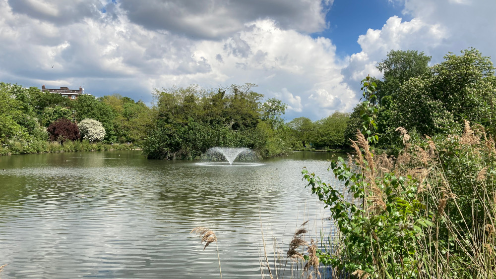
Woodberry Wetlands
 |
| Woodberry Wetlands, the former Stoke Newington East Reservoir. |
The New River was originally built to serve central London, but as the capital expanded in the 19th century the New River Company found itself struggling to meet rising demand in suburbs like Stoke Newington and Hornsey. In response to this, in 1833 it built the two Stoke Newington Reservoirs, creating 17 ha of open water on former farmland immediately to the south of the waterway itself at Woodberry Down, lined with rubble from the recently demolished medieval London Bridge. The work was led by the company’s chief surveyor William Chadwell Mylne (1781-1863), who must have had New River water in his blood: his middle name is from Chadwell Spring, the aqueduct’s main source between Hertford and Ware. Following the 1846 cholera epidemic and the discovery that the disease was largely spread by untreated water, in 1855 the company added extensive filter beds immediately southwest of the West Reservoir, on the other side of Green Lanes.
The assets of the New River Company passed to the
Metropolitan Water Board in 1903, and in 1946, it deemed the New River south of
the reservoirs surplus to requirements. Since then, the flow has ended at the East
Reservoir: its course south of here was largely filled in, though some of it can
still be seen. By the 1950s the management regime included regular use of
chlorine and sodium phosphate gas, turning the two bodies of water into dead
spaces, very different from the Brent Reservoir encountered in the last
section. In the 1980s, Thames Water, which had taken over operations in 1973, began
work on a new ring main which would make the remaining facilities at Stoke
Newington redundant. With the water company due for privatisation by the end of
the decade, both Hackney council and local campaigners feared for the future of
the site, and it was designated a Conservation Area in 1986.
The newly privatised company put the reservoirs and
associated infrastructure up for sale in 1992 with a proposal to fill them in
and build on them, claiming they would become a stagnant health hazard once the
flow of water stopped. Numerous local protests followed, with a Save the
Reservoirs Campaign joining the existing New River Action Group in arguing for
their retention and restoration as a wildlife and recreational resource. Ultimately,
while the filter beds were built on, both reservoirs remain, now a designated
Site of Metropolitan Importance for Nature Conservation. The West Reservoir is
now the property of Hackney Council and leased out to a recreational and water
sports provider. Thames Water retains the East Reservoir, which once again contributes
to the water supply system, albeit on a smaller scale than before. More
exciting for our purposes, though, is a partnership with the London Wildlife
Trust to manage its surroundings as a nature reserve which has long since
shaken off its chlorinated past.
Woodberry Wetlands Nature Reserve was officially opened by
David Attenborough in 2016, for the first time freely opening the immediate
surrounds of the East Reservoir to the public between 0900 and 1630 daily. Besides
the water and wetland edges there are hedgerows, wildflower meadows and an
orchard. The site is particularly noted for its bird life, with arctic terns
visiting in spring and siskins, great crested grebes, red kites, sparrowhawks
and buzzards also present, plus some exotic ferals like parrots and cockatiels.
Bats are common around the water’s edge and it’s also a good place for insects,
including dragonflies, damselflies and some very large and distinctive moths.
Recent developments have provided an improved setting for
some of the historic structures connected to the waterworks. After the waterway
bends, the path crosses a little street called Newton Close, here converted to
a footpath. Just to the left, a simple brick bridge with no parapet, Woodberry
Down Bridge, takes the street across the New River. The surfaces and railings
are recent, but beneath them is a Grade II-listed 18th century
structure. A little further along and more obvious is Ivy House Sluice, a small,
neat brick building spanning the waterway. Likely added in the 1830s, it contains
equipment to control the flow of water into the reservoirs, still in working
order. Just after this, views of the East Reservoir and the surrounding wetlands
open beyond the waterway.
Approaching several blocks of new flats, the path splits: the old unsurfaced New River Path continues ahead, while a much broader new promenade runs roughly parallel on the other side of the hedge. Both have their attractions: the old path is closer to the water but can get muddy and overgrown and is sometimes closed for conservation reasons. The curvaceous promenade is quite fun, passing some interesting landscaping, play equipment and a carved wooden sculpture of Mr Toad from The Wind in the Willows.
 |
| Meet Mr Toad at Woodberry Down. Poop poop! |
Whichever you choose, I can’t think of another stretch of path on the Ring that traces the interface of two such sharply contrasting environments. To the left are wide views of placid water ringed by rich vegetation, with birds wheeling above. To the right are uncompromisingly modern apartment blocks in stacked geometric shapes, all brick, glass, white render and bold lattice grids, not especially distinguished but striking in their way. In an ironically literal demonstration of the value of nature, there’s no doubt that the delightful views of the reserve have added a premium to the price of these flats.
The main entrance to the Woodberry Wetlands is on the left
not far past Mr Toad, marked by a rusted steel porch supposed to evoke a time
machine that sits very well in its leafy environment. A diversion here will
take you on a round trip past several viewpoints and the Coal House Café,
occupying another surviving 1830s Grade II-listed brick building also known as
the Gas House. If you visit, look out for the surprisingly flamboyant north end
with its baroque gable: a plaque here commemorates the building of the
reservoirs, incorporating in its decoration wolf’s head motifs derived from the
family crest of Hugh Myddleton (1560-1631), the man who led the original New
River project.
The Ring crosses Lordship Road which separates the two
reservoirs and continues its waterside course, initially past more new flats and
a terraced open area where a curtain of water flows over the sides of a giant
silver ball, tartly described by Architects for Social Housing, one of the
development’s vocal critics, as the sort of thing you’d expect to find in the
lobby of a Singapore hotel. The West Reservoir is less green but has the added
interest of sailing dinghies, canoes and kayaks as well as its bird life. After
Spring Park playground, the path is fenced and more secluded, soon with
glimpses to the right of another important survivor from the old estate: the
low but large Swedish-influenced John Scott Health Centre, opened in 1952 as a
showcase for the newly founded National Health Service. Visible across the water
at the end of the reservoir is the Filtration Plant, now known as the West
Reservoir Centre and the focus for all the water sports, including open water
swimming. Curiously, this rather elegant 1936 Moderne-style red brick building on
its prominent quayside isn’t listed.
 |
| The Castle, Stoke Newington, not what it seems. |
Finally, you reach the jewel in the crown of the reservoirs’ heritage structures, already observed from further away. Guarding the gateway from Green Lanes is a forbidding Scottish baronial-style brick castle crested with battlements and sprouting three towers. Completed in 1856, also under William Mylne, the Castle, as it’s now known, was built to house two powerful steam engines pumping water from the reservoirs to the filter beds across the road. Several of the features have a practical purpose: one of the towers is a chimney, another a water tower, while the buttresses at the front accommodated the engine flywheels. But even so it’s a delightfully fanciful building for such a utilitarian purpose, and the second of three architectural extravaganzas disguising water installations on the Capital Ring: see also the Byzantine Streatham Pumping Station on Ring 5 and the ‘cathedral of sewage’ at Abbey Mills, still to come on Ring 14.
By 1971, the Metropolitan Water Board had no more use for
the building and proposed to demolish it, but a campaign by residents and
heritage campaigners resulted in its current Grade II* listing. This didn’t
solve the problem that, like many specialised industrial structures, there was
no obvious alternative use for it. The Castle remained neglected and derelict
for many years, occasionally used as a film location: it’s featured to
advantage in Nigel Finch’s cult short thriller The Errand (1980). It was
once more threatened by the proposed sale and redevelopment of the reservoirs
in the early 1990s, but then someone had the bright idea of turning it into an
indoor climbing centre, open since 1995.
Today the continuous watercourse of the New River ends by the
Castle gates, though it originally continued under Green Lanes into the site of
the filter beds directly opposite, now covered by bland 1990s flats known as
Myddleton Avenue. It then curved back on itself to pass through Clissold Park,
where we’ll glimpse what’s left of it later. Heading south on Green Lanes, you pass
a Grade II-listed 1927 K2 phone box outside a parade of shops on the opposite
side. A few doors down on the corner of this parade is the Brownswood pub, a
rather pretty Victorian building on the west side of the road, taking the old
manorial name for the area. This was once the southeastern extremity of Hornsey
parish, allocated by the Bishops of London to the canons of St Paul’s Cathedral,
and the appearance of its name conveniently leads us into a little more
background on mediaeval Stoke Newington.
Stoke Newington
 |
| Abney House, with the newer Stoke Newington church in the background. |
Civil administration was reorganised in 1855 when both
Stoke Newington and Hackney parishes were combined into a new Hackney District,
a move that provoked considerable resentment, with the affluent residents of
the former particularly displeased at their forced marriage with their down-at-heel
neighbour. Following four unsuccessful attempts, the parishes were demerged in 1893,
but only a few years later were threatened with merger again as part of the
second tier of boroughs making up the County of London. Stokey on its own was truthfully
too small for this purpose, but Parliament, unwilling to reignite the
“intolerable and interminable feuds” of the past, allowed it to become a
Metropolitan Borough in 1899, its size augmented a little by the sensible
incorporation of the Hornsey exclaves. Then, on the creation of the Greater
London Council in 1965, it finally found itself combined with Hackney again,
along with Shoreditch, to form today’s municipality.
‘Newington’ simply means ‘New town’, a derivation it
shares with any other place names: the ‘ing’ wasn’t added until the 13th
century, while ‘Stoke’ was originally a suffix likely referring to a clearing
in a wood, used to distinguish Newington Stoke from Newington Barrow and
Newington Berners, both in Islington. The manor is recorded in the Domesday
survey of 1086 as held by St Paul’s Cathedral, a status likely dating from before
the Norman Conquest. As a ‘predendary’ manor, it was used to generate income
for the cathedral. The church maintained an interest for many centuries, as we
saw in the story of Woodberry Down, but from the 1460s the manor was leased to
a succession of wealthy Londoners, often City merchants and manufacturers.
Unlike some Middlesex parishes we’ve encountered, this one
had an obvious nucleus around the manor house and church, next door to each
other on Church Street. The London Road passed just to the east, along the line
of Roman Ermine Street, providing a link with the metropolis which made the
area yet another favoured site for big country houses. But Stokey developed a
speciality: from the 17th century it became a favoured destination
for ‘dissenters’, originally largely of the religious kind. Puritans,
presbyterians, Quakers, congregationalists, unitarians and various other
non-Anglican believers congregated here, followed throughout the 19th
and 20th centuries by political radicals: Abolitionists, Chartists, suffragettes,
supporters of home rule in Ireland and the CNT in the Spanish civil war,
socialists, communists, anarchists, feminists, anti-nuclear campaigners and
squatting activists among others. On the long roll call of former residents are
names like Daniel Defoe, Mary Wollstonecraft, Edgar Allen Poe, John Stuart Mill
and Tom Paine.
Anyone who thinks World War II ended Mosleyite fascism in
Britain should note that in 1946 a group of Jewish ex-servicemen based locally
found it necessary to set up the anti-fascist 43 Group, which in 1949 fought
hand to hand here with 200 supporters of Oswald Mosley’s Union Movement intent
on marching through the Jewish area of Stamford Hill. More notoriously, in the
early 1970s the ultra-left terrorist Angry Brigade took up residence in Amhurst
Road: members of this group prosecuted in 1971 for a series of bombings targeting
banks, embassies and the homes of Tory MPs were termed ‘The Stoke Newington
Eight’.
Stokey’s diversity increased still further in the later 20th
century as it became both more deprived and more multicultural. The authorities
took a close interest in an area regarded by some as a hotbed of anarchism, and
in the 1980s the local police station earned a reputation as particularly
brutal, repressive and racist following notorious incidents such as the unexplained
death of Colin Roach from a gunshot wound on its doorstep in 1980. But the
area’s cheapness and vibrant alternative reputation also attracted more
lifestyle-focused residents, and by the 1990s it had become an early example of
inner-city gentrification, with local property prices spiralling. Its current
reputation as a haven of moneyed ageing hipsters is perhaps best summed up by
recalling that Stoke Newington Farmer’s Market was the first in the UK to sell
exclusively organic produce. According to the Financial Times, it’s “about
one children’s clothing shop shy of becoming twee”. But, as we’ll see, it has
many attractions.
Clissold Park
 |
| Beckmere, Clissold Park, Stoke Newington. |
The first of these is the much-loved Clissold Park, one of the most delightful medium-sized parks on the trail and quite rightly included on the official register of Historic Parks and Gardens. Within its 22.6 ha, you’ll find surviving remnants of both smart Georgian country estate and proud late Victorian civic amenity, but it still manages to do a fine job of serving the contemporary local community and reflecting its vibrancy. And it’s an exemplary place to start as it owes both its existence and its current form to the local tradition of stroppy dissent.
Until the late 18th century, there were fields
here, split in ownership between two mediaeval estates. As mentioned above, a
large toe of Brownswood in Hornsey parish kicked across Green Lanes to enclose what’s
now the western half of the park, while the rest was administrated by the
Church Commissioners as part of their Stoke Newington property. Besides the New
River, the site was crossed by the Hackney Brook which ran through a band of
woodland in the north. This was quite a substantial stream, around 10 m wide
where it crossed Green Lanes. It rose from two sources near Islington’s
Holloway Road, flowing east and southeast through Highbury, Stoke Newington, Hackney,
Homerton and Hackney Wick to join the river Lea at Old Ford where we’ll meet it
again later. It was largely covered over in the 1850s, its flow diverted into
the sewer system.
In 1789, Jonathan Hoare, a wealthy Quaker merchant and
anti-slavery campaigner originally from Ireland, leased land close to the
church to build a mansion, originally known as Paradise House. By 1796 Hoare
also controlled the Brownswood lands and amalgamated his holdings to create the
rhomboid-shaped area of today as private grounds attached to the mansion. The
claypits used during construction were converted to two adjacent leaf-shaped lakes
fed by the Hackney Brook, various exotic trees were planted, and the park landscaped
into a single coherent space, effacing nearly all evidence of the parish
boundary except for a set of stone markers, only one of which survives today.
By 1800 Hoare was in financial trouble and sold the estate,
which by 1811 was occupied by William Crawshay. A nonconformist and
anti-clericalist, Crawshay was enraged when his daughter Eliza fell in love
with the local Anglican vicar, Augustus Clissold: he forbade the pair from
meeting, and by some accounts kept Eliza a virtual prisoner, even increasing
the height of the walls around the park for the purpose. William died in 1835
and Eliza inherited the estate, promptly marrying Augustus and moving him in. In
1882 the property reverted to the Crawshay family. This was a time of rapid
development in the area, which now had a rail connection, and many of the old
estates were being broken up with the cooperation of the Church Commissioners
and sold off as building land. In 1884 the Crawshays sold the lease of what was
now known as Clissold House and Park back to the Commissioners for that purpose.
Fortunately, the awkward squad of Stoke Newington had other ideas.
Joseph Beck (1828-91, an optical instrument manufacturer
and Conservative member of the City of London Corporation, who lived locally, established
the Clissold Park Preservation Committee, supported by another local politician
and open spaces campaigner, John Runtz (1818-91), Hackney’s representative on
the Metropolitan Board of Works. They argued that a public park was a necessary
asset both for public health and local amenity at a time when the remaining
open spaces in Stoke Newington were being covered in housing. Despite a
petition attracting 12,000 signatures, they struggled to raise the necessary
cash: approaches to neighbouring parishes whose inhabitants would also benefit
were spurned, sometimes in intemperate terms, and opponents dishonestly
inflated the miniscule increase proposed to the local rates. Finally, after several
years of hard-fought campaigning, the MBW agreed to use its new powers of
compulsory purchase, buying the estate in 1888.
By the time the park first welcomed the public the
following year, the MBW had metamorphosed into the London County Council and,
like Finsbury Park and other MBW creations, Clissold was subsequently inherited
by the Greater London Council in 1965 and the borough council, Hackney, in
1986. It never became quite as badly neglected as Finsbury Park, though a
Heritage Lottery Fund-backed £8.9million restoration project in 2011 was
certainly welcome. Unsurprisingly, there’s an active User Group, founded in 2000.
The Ring enters through Lodge Gate in the northwest corner
and, while the New River Walk parts company with us here by heading south along
the eastern perimeter, our way is ahead alongside the larger of the two lakes,
now named Beckmere; its neighbour, appropriately, is Runtzmere. The parish
boundary entered at approximately the line of the gate and continued straight
ahead into Beckmere before turning southeast, so the Ring briefly returns to
historic Hornsey here, re-entering Stoke Newington about halfway along the
bank. At the gap between the two lakes, you turn towards the house along an
avenue laid out in Jonathan Hoare’s time. The Grade II*-listed brick mansion is
a handsome affair, rendered even more imposing by the grassy landscaped slope
that rises to its fine portico of Doric columns. It’s long housed a popular
park café and is also used as a wedding venue.
The trail turns left just before passing the house, but
there’s an opportunity for a brief detour. Only a few paces ahead and opposite
the portico is what remains of the original course of the New River. Behind
this is the animal enclosure, one of the original park features and the first
of its kind. Deer have been in residence since 1890: today there’s a small herd
of fallow deer as well as goats and an aviary for exotic birds. Beyond the
enclosures is a pioneering urban market garden, established by not-for-profit
group Growing Communities in 1996. They now have two others in Hackney, one of
which we’ll pass close to later: the Clissold site is particularly noted for
its melons. The parish boundary tracked the east side of the New River,
parallel to the drive, and just inside the main gate ahead is the last
remaining boundary stone, dated 1790.
Back on the main trail, you’ll pass the north end of the
house, with its decorative fountain installed in 1893 by Rose Crawshay, born
Yeates, to commemorate three of her sisters who died in early childhood. You
can now see the full effect of that slope at the front, as at the rear the
house grows an extra lower storey. Then there are some attractive formal
gardens, a playground and a skateboard park before you leave by the Town Hall
Gate.
I’ll leave the last word to the park’s joint creator, Joseph Beck, as quoted by local historian Amir Dotan:
It will be from the narrow streets of Shoreditch, from the pent-up alleys of Clerkenwell and Islington, that thousands and tens of thousands of our fellow beings will issue to enjoy the sweet breezes and lie under the shade of the old and handsome trees of Clissold Park. It will be on the soft grass that the little ones will romp and play and learn the charm of getting for a short time under the benignant influence of bright sunshine and fresh air.
Stoke Newington Church Street
 |
| Stoke Newington Town Hall. |
In the churchyard alongside the path is the tomb of James
Stephen (1758-1832), the legal brain behind the banning of slavery in the
British Empire. Stephen’s personal convictions were formed when he was
Solicitor-General of St Kitts in the Caribbean and witnessed four black men
sentenced to death by burning for a murder they very likely didn’t commit. His
father lived in the Summerhouse on the nearby Fleetwood House estate with
several prominent Quaker abolitionists as neighbours, and his second wife was
Sarah Wilberforce, sister of abolitionist leader William Wilberforce. Although
not a Quaker himself, Stephen became a mainstay of abolitionism: a qualified
barrister and later an MP, he was well-placed to draft what became the Slave
Trade Act of 1807. Both Sarah and her sister are buried nearby, as is Romantic
poet and children’s author Anna Laetitia Barbauld (1743-1825), another local
radical and prominent opponent of slavery.
The rapid population growth of the first half of the 19th
century prompted calls for a new, larger church, answered in 1858 by the
building immediately opposite as you emerge on Church Street, an imposing ‘early
decorated’ Gothic Revival pile designed by George Gilbert Scott of St Pancras
fame. The capacious nave was regularly filled in the early days by congregants
who came from all over London to hear the dynamic preaching of its first vicar,
Thomas Jackson. The tall steeple, which has been visible for some time, wasn’t
completed until 1890 under Scott’s son John Oldrid Scott, leading local wits to
quip:
Most people find
the older building more likeable, but both together say much about Stoke
Newington’s transition from a Middlesex village to a prosperous suburb.
You soon pass another prominent building from a further
chapter of local history. When the Metropolitan Borough was first created in
1899, it operated from modest offices, but by the 1930s local councillors
wanted something that more adequately reflected civic pride. The result, opened
in 1937, was Stoke Newington Town Hall, a substantial combination of municipal
offices, council chamber and assembly hall designed in eclectic style by John
Reginald Truelove, with elements of Classical and renaissance architecture and
1930s monumentalism. It’s particularly notable for the curved end section, the
grand entrance to the assembly hall and a sumptuous art deco interior which
includes a sprung Canadian maple dance floor. During its construction, builders
discovered the foundations of the manor house, demolished in 1695. Look
carefully and you can still see the remains of World War II camouflage paint on
the exterior. Following the creation of the London Borough of Hackney, the
building was largely disused and fell into neglect but was restored and reopened
as an events venue in 2010.
The Ring follows Church Street for a while. As mentioned
above, this was the original village street, and retains a very strong sense of
character that prompted architecture critic Nikolaus Pevsner to remark in 1953
that “Stoke Newington is not entirely London yet”. In the 18th
century it was flanked by big houses set back behind gardens, but as it evolved
into a busy retail centre, premises began to reach forward to the thoroughfare.
It still has numerous listed and other historic buildings, many of them happily
still occupied by independent and specialist retailers: artisanal food shops
and restaurants, specialist wine and craft beer dealers, upcycled furniture and
jewellery traders, a violin maker, and yes, the odd kid’s clothes boutique.
Opposite the Town Hall, the Rose and Crown pub on the
corner of Albion Road is an impressive neo-Georgian Truman’s rebuild with a smart
1930s oak-panelled interior. Nos 169-183, the block immediately east of Albion
Road, is all 18th and 19th century buildings, including
several showing projecting shop fronts and a fine pair of three storey town
houses built in 1717. A brown plaque at no 173 records that these buildings
replaced a medieval mansion, demolished around 1710. Opposite, the red brick public
library building with its distinctive gables predates the town hall next door:
it was built in 1892 but extended twice in the early 20th century,
thanks in part to a donation from Andrew Carnegie. Above the second door is a
World War I memorial based around a niche, which is easy to miss. Edgar Allen
Poe was once a pupil at Manor House School on the site of no 172, as mentioned
on a plaque.
Across the small green space next to Nandos on the right is another fine three-storey house, Bilney Lodge, perhaps dating from the 1730s, with a taller building from around the same time next door. Nandos itself, incidentally, once housed the Vortex Jazz Club, where your author regularly hosted a musical cabaret and chanson night in the 1990s. The Red Lion opposite isn’t listed but is a handsome Dutch-style Truman’s interwar building with two relief plaques outside. Several more 18th century buildings fronted by Victorian shops occupy the row between 105 and 117: one has the remains of early 20th century advertising for fountain pens, and there’s a brown plaque for Anna Barbauld at 113. The Clarence Tavern on the left is an elegant mid-19th century building with its name repeated on an inscribed parapet, then there’s another run of prosperous Georgian houses, this time without shops, nos 75-93 on the right. Just round the side of no 75, on Defoe Road, is a blue plaque recalling Daniel Defoe lived in a house on the site.
There’s one more plaque of interest, on a pillar just
before the cemetery fence on the left, recalling that the gateway to Abney
House stood here between 1700 and 1843. The history of both house and cemetery
are intertwined, as we’re about to discover.
Abney Park Cemetery


Abney Park Cemetery. Left: the Bostock lion; Right: the chapel.
At the start of the 18th century, two large
houses stood in extensive grounds to the north of Church Street at its eastern
end. The western plot had been acquired by an alderman of the City of London,
Thomas Gunston, who in 1699 also bought out the manorial lands, becoming lord
of the manor. As the ancient manor house on what’s now the town hall site was
already demolished, Gunston began building a new house further east. When he died
in 1701, the estate passed to his sister Mary (1676-1750), wife of co-founder
of the Bank of England and sometime Lord Mayor of London Thomas Abney, so
became known as Abney House and Abney Park. Mary, a Congregationalist, moved
into the house permanently when she was widowed in 1722 and began landscaping
the grounds into a verdant country estate. In this she was assisted by an old
friend, longstanding house guest and keen amateur naturalist, Dr Isaac Watts
(1674-1748), best known as the nonconformist hymn writer credited with ‘Our
God, our help in ages past’ among around 750 others. The estate retained its
nonconformist leanings even after private occupation ceased: it housed a
Methodist training college between 1838 and demolition in 1843.
Next door was Fleetwood House, built in 1634 but named for
one of Oliver Cromwell’s generals, Charles Fleetwood, who acquired it by
marriage in 1664. For much of the 18th century it was occupied by
the Hartopp family, good friends of the Abneys, who cooperated in laying out
the parkland. Unsurprisingly, it was a noted meeting place for nonconformists
and housed a Quaker school from the 1820s. The Summerhouse, the residence of
the Stephen family mentioned above, was in the grounds. The house was demolished
in 1872 and a fire station now stands on the site. Masonry from both this house
and Abney House was recycled for new buildings along Church Street.
One of the practical problems caused by London’s late 18th
and early 19th century expansion was a surfeit of corpses. For
centuries, most burials took place in small churchyards which were now
overflowing. An act of parliament in 1832 encouraged the establishment of
private suburban cemeteries, following the model of Père Lachaise in Paris, established
in 1802. Seven such facilities opened around London in the next decade, later
dubbed the ‘Magnificent Seven’. Abney Park Cemetery was the fourth of these,
and the only one on the Capital Ring, created in 1840 from the grounds of Abney
House and Fleetwood House.
Abney Park is unique among the Seven in several ways. It’s
the only one that’s not consecrated ground; it was planned as a
non-denominational facility open to those of all religions and none, taking
advantage of the impeccable nonconformist history of its site. It was also the
first cemetery in Europe to be combined with an arboretum: building on the
tradition established by Abney and Watts, it was intended as an educational
attraction as well as a burial ground, inspired by models in New England. It
was planted with 2,500 different species of trees and shrubs, the former
arranged alphabetically around the perimeter walk. The delights of what was
then regarded as London’s most Sylvan cemetery were eloquently reported by New
York visitor and Watts fan David W Bartlett in an 1861 book:
There is a beautiful cemetery in Stoke Newington…, no quieter burial spot within a dozen miles of London in any direction, and there are cedars of Lebanon in it, wide lawns, and beautiful flowers. There is an old clergyman in the church [chapel], who is always ready to officiate for a small fee on funeral occasions. He is over eighty years old, his hair is like the snow, and he is a fit companion to such a solemn place. One shining evening, with a female friend we visited the cemetery, and stopped… to talk with the venerable clergyman. The tears actually sprung over his eyelids when we said that we came from America. The old man asked a thousand questions about the wonderful far land of liberty in the west, which we were glad to answer.
By then, though, the botanical rigour of the site had
begun to slip following the closure of the nursery in the 1850s. Flaws in the
original business model, a not-for-profit trust, led to a court case and in the
1880s the cemetery passed to a commercially minded new owner who had little sympathy
with the original aims. New graves were crammed into every available space,
removing much of the original planting in the process. The company went into
liquidation in the early 1970s and the cemetery, by now containing almost
200,000 burials, was abandoned and rapidly overrun by nature. Hackney council
took over in 1978 and in the early 1980s, in consultation with the locals,
reopened the site as a public green space and nature reserve rather than a
working cemetery, though there have been a few discretionary burials since for
descendants of historic plot-holders. It’s currently managed in partnership
with an independent charity, the Abney Park Trust, and there’s an active user
group. Major restoration work funded by a £4.4million package from the Heritage
Lottery Fund and others began in 2020, so there may be some changes, including
the opening of a new visitor centre and café.
The current management regime has done a great job of
balancing nature, heritage and public access needs while maintaining the unique
atmosphere of the place – which now includes the legacy of past exploitation
and neglect, such as the higgledy-piggledy burials, crumbling monuments and
overgrowth. There’s so much of interest, both in terms of nature and monuments,
that I can only scrape the surface here: the Abney Park Trust has more detailed
guides and suggested walks. Among the occupants we won’t point out along the
way are Welsh nurse Betsi Cadwaladr (1789-1860), who worked alongside Florence
Nightingale during the Crimean War but was buried in a pauper’s grave that was
only marked in 2012; William Calcraft (1800-79), one of England’s most prolific
hangmen, who carried out the last public execution in 1868; singer, songwriter
and comedian Albert Chevalier (1861-1923), the ‘costers’ laureate’ and author
of ‘Knocked ‘em in the Old Kent Road’ and ‘My Old Dutch’, as well as several
other prominent music hall stars; Margaret Graham (c1804-c1880), the first
British woman to make a solo balloon flight in 1826; William Tyler (1877-1909),
a police constable shot dead while trying to arrest Latvian anarchists engaged
in a wages robbery, an incident dubbed the ‘Tottenham Outrage’; Joanna Vassa
(1795-1857), daughter of former slave and abolitionist Olaudah Equiano, whose
grave was rediscovered in 2005; and Afro-Caribbean writer Eric D Walrond
(1898-1966), a key figure in the Harlem Renaissance.
One of the best-known monuments is visible as soon as the
Ring enters the cemetery, marking the graves of Methodist preacher William
Booth (1829-1912) and his wife Catherine (1829-1890), who founded the Salvation
Army, originally known as the East London Christian Mission, in 1865. Booth’s
funeral procession to his final resting place stretched for miles. Several of
his comrades are buried in the same plot, including son Bramwell.
The Ring follows the Long Ride to the left of the
Salvationist plot. Just along the second path to the right is a square pillar
marking the grave of James Braidwood (1800-61), founder of one of the world’s
first municipal fire services in Edinburgh in 1824 and the first director of
the London Fire Brigade from 1833: he died fighting a fire at Cotton’s Wharf,
Southwark. Curiously, he was also a witness at the trial of William Burke, notorious
grave robbing partner of William Hare, in 1828. Perhaps the most admired
memorial is on the right before the main path crossing, a magnificent sleeping
lion in white marble comfortably sprawled over the chest tomb of menagerist and
animal trainer Frank C Bostock (1866-1912): the sculpture is a copy of one in
Highgate Cemetery.
The path continuing ahead at the crossing is Great Elm
Walk, one of the features originally laid out by Mary Abney, but our way is
right along Wilson Ride to the little chapel so admired by David Bartlett. He
mistakenly called it a ‘church’ but it was always a funeral chapel rather than
a place of worship. It’s the only surviving building designed by William
Hosking (1800-61), and is in a broadly Gothic style but, in line with cemetery
policy, tries hard not to favour any one Christian sect, with a plan based on
the equal arms of the Greek cross: the extended southern section is a porte-cochère
for sheltering funeral carriages rather than part of the chapel proper. The
rose windows were intended to reference the rosarium which was an original
feature of the site. The chapel has long been on the at-risk register following
neglect, vandalism and arson attacks in the 1980s but is currently undergoing
restoration.
Opposite the chapel is the Commonwealth War Memorial with
its Cross of Sacrifice installed in 1922: it contains the remains of 262
military victims of World War I and another 113 from World War II. Behind this
is Watts Walk with its 1845 statue commemorating the hymn writer. There’s another
site in the cemetery closely associated with Watts, a mound in the extreme
northeast corner where he supposedly sat and wrote. This is also one of several
places claimed to hold the last remains of Oliver Cromwell. History records
that the former Lord Protector’s body was exhumed from Westminster Abbey following
the Restoration in 1661 and subjected to a posthumous execution, but there were
persistent rumours that the remains of the real Cromwell had already been
removed and reburied by republicans fearing just such an outrage. Watts’ own
remains aren’t at Abney Park but another, earlier, nonconformist plot, Bunhill Fields
just outside the City of London.
The Ring continues east along Chapel Ride, passing a
prominent chest tomb with quatrefoil ends on the right, another individually
listed structure. It commemorates architect and religious dissenter Samuel
Robinson (1752-1833) and was originally outside some alms houses he endowed in
Hackney but was moved here in 1901. A little past this on the same side is a
Bhutan pine, one of the few remaining trees from the original arboretum.
You leave the cemetery through the main gates onto Stoke
Newington High Street. These and their attached lodge bring an unexpected
Egyptian Revival flourish to this corner of northeast London, with bold stone
piers topped with coved cornices in lotus and palm leaf patterns, forbidding
black doors and hieroglyphic carvings. The style reflects the early Victorian
obsession with ancient Egypt, prompted first by Napoléon Bonaparte’s occupation
between 1799 and 1801 and then by growing British and other European interests
in the country that facilitated a wave of archaeological expeditions in the
following decades. But it also serves the non-denominational policy: what
better way to make a ceremonial entrance appropriately solemn without favouring
any current religion than by borrowing the symbolism of an extinct one. Hieroglyphs
on the lodge welcome visitors to “the abode of the mortal part of humanity”;
similar wording was included on a pavement plaque just inside the gates in 1992
but, much like the treasures of the pharaohs’ tombs, this was stolen almost
immediately. Before finally leaving the mortal abode, we should note that since
it was built, it’s yielded evidence of human activity long predating the
culture that inspired it, as we’ll shortly discover.
Stoke Newington High Street
In Roman times, the main road north from London left the City by Bishopsgate, following Shoreditch High Street, Kingsland Road and Stoke Newington High Street towards Tottenham, Enfield, Royston, Huntingdon and on to York. The Anglo-Saxons called this road Earninga Stræte, or Ermine Street, after a tribe called the Earningas who lived near Royston. It was the main route north until the 14th century when, thanks in part to problems crossing the river Lea at either Hertford or Ware, it was gradually superseded by the Great North Road described in the previous section, after which it became known as the Old North Road. It remains an important trunk road, since the 1920s designated as part of the A10 from London to Cambridge and Kings Lynn. Where we leave the cemetery, it’s still known as Stoke Newington High Street, but north of the junction with Cazenove Road opposite and slightly left it becomes Stamford Hill as it starts climbing the geographical feature of that name. The name changes here as, at that junction, Ermine Street crossed the former line of the Hackney Brook at the ‘stony ford’ that gives Stamford hill its name. The stream turned roughly south, away from our route, on the other side of the main road.
As previously mentioned, Ermine Street was the eastern
boundary of the old Stoke Newington Parish, so in crossing it we reach the
territory of its longstanding rival parish of Hackney. Following the subdivision
of the old Ossulstone Hundred of Middlesex in the 17th century, this
was also a boundary between divisions, with Stoke Newington in Finsbury and
Hackney in Tower Division.
So there’s a hair-splitting argument to say that Stoke
Newington station, where Ring 12 ends a little north of the Cazenove Road
junction on the east side of Stamford Hill, isn’t actually in Stoke Newington. The
line here, now usually known as the Seven Sisters branch of the Lea Valley
Lines, was opened by the Great Eastern Railway in 1872 as a shortcut from
London to Enfield. It left the main line from Bishopsgate (later Liverpool
Street) at Bethnal Green to run via Hackney Downs and Seven Sisters: previously
the rail journey had involved travelling east to Stratford, then along the
original Lea Valley Line via Tottenham Hale and a branch line, since closed,
between Angel Road and Lower Edmonton. Stoke Newington was one of the original
stations, helping trigger the building craze that spurred the creators of
Clissold Park to action. There’s some original brickwork at platform level, but
the current street level building is an undistinguished smoked glass and steel
box installed in the early 1980s. If you’re rejoining the Ring here, a
half-hidden alleyway parallel to the railway known as Willow Cottages provides a
convenient cut to Cazenove Road.
Stamford Hill to Upper Clapton
 |
| Stamford Hill, the line of Roman Ermine Street, looking north. |
These apparently eccentric efforts uncovered what’s now
regarded as one of the most important palaeolithic sites in northern Europe. Over
four years in the 1880s, Smith collected 200 complete flint axes and ‘hundreds
of thousands’ of flakes in a layer he named the ‘palaeolithic floor’, dating
from the old stone age of perhaps 300,000 years ago. This is long before the
last glacial period when the Thames and its tributaries found their current
courses, and the toolmakers were likely our mysterious extinct cousins Homo
neanderthalensis rather than H. sapiens. The concentration of finds,
including broken fragments of the same tool in the same place, has prompted
suggestions that this was a ‘factory’, a centralised facility supplying tools
over a wide area. Some of the artefacts were likely too big and heavy to be of
practical use, suggesting they were appreciated for their craftsmanship and used
to indicate status. Some are now on display in the Museum of London.
The Ring plods the leafy residential streets that arose
from the building sites so assiduously patrolled by Worthington Smith. Originally
Stoke Newington common extended over a wide area immediately to the east of the
London Road, and went by the picturesque name of Cockhanger Green or,
sometimes, Shaklewell common, only gaining its current name in the later 19th
century as locals’ idea of Stoke Newington expanded eastward with development. By
the 1860s the land was controlled by the Tyssen-Amhurst family, and the
northern part had already been converted to market gardens. Just over 2 ha of
the southern part, off our route, remains as a green space, publicly owned
since 1872, though carved up by roads and railway.
Development took place between 1865-1895 with various
architects and builders, though under strict family control, giving a pleasing
combination of diversity and unity, with most of the houses constructed of buff
London brick – that special character has since been acknowledged with the
designation of the Northwold and Cazenove Conservation Area. Smith found worked flints to the south (right)
of Cazenove Road, on the site of what are now flats just past the railway
bridge, and in the foundations of houses along the southern sections of Alkham
Road and Kyverdale Road.
The streets of the conservation area north of Cazenove
Road run up towards Stamford Hill, home to one of the biggest Hasidic or Haredi
‘ultra-orthodox’ Jewish communities in Europe. ‘Haredi’ means ‘one who trembles
at the word of God’, and you’ll likely pass members of the community in their
distinctive dress as you walk north along Kyverdale Road and east on Filey
Avenue, particularly on Saturday’s shabbos: men with beards or payos
sidelocks, in black suits, old-fashioned black frock coats and homburg or fur
hats, women in dark ‘modest dress’ with long skirts and sleeves, usually
conversing in Yiddish.
Better-off Jewish people began moving to Stamford Hill
from the East End in the 1920s, but the Haredi community expanded significantly
in the 1930s when people fleeing Nazi Germany settled in the area. The tendency
of established immigrant communities to attract further members was
particularly compelling for the Haredim, whose lifestyle in its strictest form
requires rejecting numerous aspects of life most of us take for granted, so new
arrivals in the postwar years were attracted by an already supportive network. The
result was what’s sometimes called a ‘square mile of piety’ in northeast London,
with five community centres, 90 synagogues and 30 orthodox schools serving an
estimated 40,000 people.
Simon Marks School on the corner of Cazenove and Kyverdale
roads is an orthodox Jewish school but not Haredi, instead affiliated to the
more mainstream United Synagogue: it’s now the only remaining mixed sex Jewish school
in inner London and welcomes children from other backgrounds too. It began in
1956 at a now-demolished synagogue in Lea Bridge Road and moved here in 1973.
Other than subtly pleasing decorations on some of the houses, there’s not much
to look out for until another primary school, this time secular: glance down at
the pavement as you pass Jubilee School on Filey Avenue to see some unexpected
artwork designed by children. Reaching the main Upper Clapton Road, the Ring
turns left to cross it just in front of a small synagogue: a little to the
right on the opposite side, by the bus stops, is a listed supposedly Victorian
pillar box, except that the current box is clearly marked GVIR, dating it to
the later reign of George VI (1936-52). It was likely moved here in the late
1990s as a replacement for the Victorian original.
It's time I introduced the parish of Hackney, which the
Ring entered when it crossed Stamford Hill on leaving Abney Park Cemetery.
Hackney was by far the largest of the parishes in the old Tower Division of
Middlesex’s Ossulstone Hundred, occupying roughly the northern third of the
division between Ermine Streeet and river Lea. The origin of the place name is
uncertain: it may mean ‘Haka’s island’, after a personal name, or ‘hack’ may
refer to a gate (hatch) into a woodland or a hook or bend in a river. The
balance of evidence, incidentally, suggests the traditional term ‘Hackney
carriage’ for a taxicab is nothing to do with the place name but evolved
separately from a word for a type of horse.
In the early middle ages, the area was part of the Bishops
of London’s huge manor of Stepney, of which it had become a sub-manor by the
Norman conquest in 1066. It had a parish church by 1275, in the central village
also known as Hackney, along Mare Street some distance southwest of our route. In
1550 it passed into private hands and was eventually divided into sub-manors,
soon becoming a popular rural retreat of prosperous London merchants. By 1699
much of it, including most of this part of the trail, was in the hands of the
Tyssen family mentioned above, originally merchants from Vlissingen in the
Netherlands. It was almost entirely built up during the 19th century
as an overspill from the East End and in the 20th century became one
of London’s most diverse, and one of its most deprived areas, though much has
been gentrified recently. As described above, after various 19th
century boundary disputes, it eventually merged with Stoke Newington and Shoreditch
to create the modern London Borough of Hackney in 1965.
The locality we now cross is known as Clapton, meaning ‘hill
farm’, the hill likely referring to the land that rose sharply here from the
Lea Valley. First mentioned in 1339, Clapton was originally a sprawling linear
hamlet along a bow-shaped road once known as Hackney Lane from Hackney village
to Clapton Common, a little north of where we cross, and Stamford Hill where it
joined Ermine Street. By 1800, the area was habitually divided into Lower
Clapton, south of Lea Bridge Road, and Upper Clapton, our current location
north of it, and the road, today’s A107, became known as Lower and Upper
Clapton Road accordingly. By this point the road was urbanised all the way to
the common, though there were still fields beyond it and Upper Clapton was
regarded as a select suburb. Nearly all of it was built up by the end of the 19th
century, but the busy scene today, with numerous high density flat blocks, is partly
the result of 1930s redevelopment by councils, housing associations and private
investors.
Springfield Park
 |
| Surely one of London's best views: Walthamstow marshes from Springfield Park, Upper Clapton. |
The ‘uplifting’ location was one of the reasons why the
London County Council chose the site for a park to serve the increasingly
densely populated area in 1904. The land had once been meadows but by the 18th
century a wharf known as Giles’s Dock, long since filled in, poked out from a
bend in the river into what’s now the sports field in the northeast of the site,
serving a cluster of small factories making calico, tiles and varnish. As Upper
Clapton began to evolve into a select suburb at the end of the century, three
villas were built to take advantage of the views, each with extensive grounds. The
LCC bought and amalgamated these properties to create the park, which was designed
like several others along the trail by chief parks officer J J Sexby and opened
in 1905.
One of the houses, Springfield Lodge, remains near where
we enter in the southwest corner, now known as the White Lodge or White House.
The others – Spring House, in the northwest corner, and the oldest, the
Chestnuts, in the flat part of the park at the bottom of the slope to the
northeast – were demolished, along with several cottages, but several of the
paths, plantings and other features in their grounds were preserved. The
references to springs aren’t idle: water emerges here from the interface between
the gravel and brick earth on the higher ground and the London clay beneath and
there are wells marked on 19th century maps.
The Ring enters through Springfield Gate, once the house
access, passing a pond in lush surrounds which once belonged to the house and
was slightly expanded when the park was built. The White Lodge itself is soon
in view, a sturdy early 19th century Grade II-listed building with a
Doric porch and two bow windows on the east side which now houses offices,
public toilets and a renowned café. Behind it, slightly off our route, is the
Glass House, an impressive events venue opened in 2021 to replace Victorian
glasshouses which had fallen into disrepair. Turning away from the house the
views open and the trail descends the grassy slope to reach a crossing by a woodland
corner: the path to the left here leads past the site of one of the wells to a bandstand
that’s still occasionally used for music. Our route continues ahead to leave
the park through a gate onto Spring Lane, a footpath beside the river at the
foot of Wilson Hill.
Walthamstow Marshes
 |
| Springfield Marina, Walthamstow marshes. |
Running for 68 km between Leagrave north of Luton, east,
southeast and south to its confluence at Leamouth, Poplar, almost opposite the
O2, the Lea is one of the longest of the Thames tributaries, with
the biggest catchment. Long an important commercial artery, particularly for
grain grown in Essex and Hertfordshire and consumed in London, it was
progressively canalised from the 12th century and became a formally
managed waterway, the River Lee Navigation, around 42 km between Hertford and
Bow, in the later 18th century, combining ‘improved’ stretches of
natural course and new cuts and now managed by the Canal and River Trust. Unusually,
the river’s name has two acceptable spellings with no agreement as to which is
correct, though ‘Lea’ is often preferred for the natural river and its valley
and ‘Lee’ for the navigation and associated infrastructure, a practice I’ve
followed here.
Though residential development stayed clear of the
riverside to avoid flood risk, the lower part of the valley was intensively
used for industry and agriculture: nurseries and gravel extraction,
particularly in the northern section, reservoirs and waterworks, and heavy
industry in the south, taking advantage of the transport opportunities. By the
1930s much of this was in decline, providing an opportunity to create a vast recreational
resource for densely populated east London by reclaiming derelict sites and
connecting them to the remaining undeveloped areas. This vision was included in
the Greater London Plan of 1944 but only began to be realised in 1966 with the
creation of a statutory Lee Valley Regional Park Authority following much
lobbying and campaigning by local politicians and others.
Today’s Lee Valley Park encompasses 40 square km along the
valley between Ware in Hertfordshire and Leamouth, including the Queen
Elizabeth Olympic Park which we’ll later visit, with more under development,
particularly along the lowest reaches of the river. Though it’s dotted with
built leisure facilities, the vast majority is public green space managed for
informal recreation and nature conservation. It’s a magnificent resource and
one of London’s green jewels, easily equalling the Royal Parks and exceeding
them in extent.
Since the early 1990s, an 80 km walking trail, the Lea Valley Walk, has followed the river from Leagrave to Bow, with a variety of
options to continue from there to the Thames: I plan eventually to cover the
London sections of this in more detail in later posts. Below Hertford the Lea
Valley Walk simply follows the existing navigation towpath, and the Ring now
takes advantage of the same infrastructure for the next 6 km south downstream to
Old Ford, a short distance into the next section.
The river carries an ancient boundary. When the Anglo-Saxon
province of Middlesex (‘territory of the Middle Saxons’) was carved out of the
Kingdom of Essex (‘territory of the East Saxons’), likely some time in the 7th
century, the Lea marked its eastern extent. In 886 the Anglo-Saxon king of
Wessex, Alfred, retook London from the invading Danes, and under the subsequent
treaty agreed with his opponent Guðrum the river was incorporated into the
western boundary of the Danelaw, that part of England governed by Danes. It continued
to divide the later counties of Middlesex and Essex and in 1889 became part of
the boundary of the newly formed county of London, so the Ring is once again
about to leave the ‘metropolis’ as it was before the creation of Greater London
in 1965. While that development subsumed land on both banks into the capital,
the Lea still demarcates the boroughs of Enfield, Haringey, Hackney and Tower
Hamlets on the western, former Middlesex side and Waltham Forest and Newham on
the eastern, former Essex side. Where the navigation divides from the natural
course, the boundary normally follows the latter, but in some places it’s been
realigned along more recent cuts.
The land immediately opposite here was once part of
Walthamstow parish in the Essex hundred of Becontree, which still preserves its
medieval nucleus as a conservation area some distance east. Today it’s part of
the London Borough of Waltham Forest, and there’s considerable confusion over
these names. ‘Waltham’ is an old English place name meaning ‘settlement by (or
in) a wood’, cognate with the common German name Waldheim. There was certainly
once much woodland in the vicinity as it comprised part of the Norman Forest of
Essex, fragments of which survive today as Epping and Hainault Forests on the
eastern edge of London and Hatfield Forest much further north, near Stansted
Airport. In the 13th century the forest was split up and this part
became Waltham Forest, which encompassed Epping and Hainault. The redundancy in
the name is only apparent – as I’ve had occasion to remark before in London
Underfoot, the term ‘forest’ was once a legal designation for a broad area
reserved by royals or other nobles for hunting purposes and wasn’t necessarily
continuously wooded.
Walthamstow, on the other hand, first appears at the time
of the Norman Conquest in 1066 as Wilcumestowe, which could mean a place
belonging to someone called Wilcume or, more likely, a place where strangers
are welcome. Predecessors of the modern form appeared in the 15th
century, it seems through a confusion with Waltham Forest. To complicate things
further, the Saxon lord of the manor in 1066 was Waltheof, earl of Huntingdon, so
perhaps his name was blended into the mix too. Waltheof was executed for conspiracy
in 1076 and the manor subsequently passed through numerous hands, with a
portion to the southwest split off as the sub-manor of Walthamstow Bedyk or Low
Hall in the early 14th century: its last holders, between the 1740s
and the 1930s, were the Bosanquet family. Technically, it included the common
marshes along our route, although these were never managed as private farmland.
Walthamstow was included in the London Postal District in
the 1850s though not in the new county of London in 1889, which stopped at the
Lea and never included any part of Essex. But the locality was sufficiently
developed to become an Urban District in 1894 and in 1920 the council actively
petitioned to be included in the capital. In the event this didn’t happen until
the creation of Greater London in 1965, when Walthamstow was combined with Chingford
and Leyton to create the modern London Borough of Waltham Forest, reviving the
old forest name.
The Ring crosses the canalised river on Horseshoe Bridge,
no 20, and it’s worth pausing not just to mark your passage into the trail’s
last historic county but to observe the surroundings. To the right, downstream, the navigation
follows more-or-less the natural course. To the left, upstream, the river
originally formed a tight meander to the northeast, the ’horseshoe’ from which
the bridge takes its name. The current straighter course was dug in 1878 and
the local authority boundary realigned to follow it: the commemorative spade
used to inaugurate the work is now in the Science Museum in Kensington. The
bridge you’re standing on was built as part of the project.
The original course was left as a creek and the island within
it was later used as a boatbuilding yard. In 1969 it became one of the newly created
park authority’s first projects when it was converted into the Springfield Marina, still very much visible and active today. Spoil from digging the new
moorings was dumped nearby and allowed to grow naturally, creating the fenced
area visible immediately ahead, known as Horseshoe Thicket. It’s an atmospheric
patchwork of secondary woodland and small ponds, rich in wildlife, and worth a
wander if you have time. The Green London Way, which takes a more circuitous route
through Springfield Park and crosses the river at the next bridge upstream,
High Bridge, works its way around the marina and through the thicket but the
Ring prefers a more direct course straight down the towpath.
The flat, grassy Walthamstow marshes that stretch out beyond, striated
by railway viaducts and lines of pylons and kettled by industrial estates and
flat blocks, are one of London’s most unusual and ecologically valuable
environments. Most people find the surroundings here atmospheric rather than
beautiful, and this stretch can feel surprisingly remote and desolate despite
the dense residential areas just across the river. My Dutch ancestry
predisposes me to appreciate damp, flat landscapes, but I once found myself
having to recce a led walk here on a cool, windy, wet spring day and, lashed by
chill winds and drizzle, it felt like walking on the edge of the world. But on
the day of the walk the sun came out, insects buzzed in the long grass beside
the river and all was well with the world.
 |
| Walthamstow marshes, one of London's most precious environments. |
The marshes were once much wetter, but they were likely drained long before the Normans – by Alfred in 876, according to the not necessarily reliable Anglo-Saxon chronicles – and managed as lammas land. From Lady Day, March 25, until Lammas Day on 1 August, a descendant of the Celtic summer festival of Lugnasad, they were used for hay farming, then opened to common grazing for the rest of the year. The northern part was taken by gravel extraction and reservoirs in the 19th century but around 37 ha remarkably survived and was still used for rough grazing until the 1930s.
With traditional management in terminal decline, the
council bought the land to safeguard it for recreational use, but plans were
interrupted by World War II and instead the marshes were transferred to the Lea
Valley Park soon after the latter was created in 1965. In the absence of grazing,
taller plants began to grow, and parts developed into secondary woodland, creating
an unusual mix which was almost lost in 1979 when the council and the park authority, then much less concerned about conservation than it is today, planned to lease the site for gravel extraction. Thanks predominantly to the actions of local campaigners, the proposal was rejected by the GLC, and the marshes were designated as a Site of Special Scientific
Interest (SSSI) in 1985: they now also form a Local Nature Reserve (LNR). Grazing
during the summer months was reintroduced in 2003 to further boost diversity. Rare
species here include adder’s tongue fern, an indicator of ancient grassland,
and significant populations of the rare water vole.
The Ring and the Lea Valley Walk, the latter signed with a
swan logo, follow the broad gravel track, though there’s a narrower unsurfaced
path closer to the water’s edge. As the track bends gently left towards the
railway bridge, flats are visible on the opposite bank. A ferry operated here
until the late 19th century and its former landing on the Hackney
side was once a tiny extension of Essex west of the Lea. The street is still
called High Hill Ferry today. Just past the flats, on the same bank, is an
imposing three-storey red brick building with an attic, the former Beehive pub.
This was one of two that served the ferry: the second, the Anchor and Hope, a
few doors further along, is a charming place that survives as a pub today.
The railway bridge, known as Ferry Bridge, is part of a
tangle of lines along the valley and into eastern Hertfordshire and western
Essex known, understandably, as the Lea Valley Lines. The oldest visible line
is the one running roughly parallel to the river across the marshes to the
left: this is the West Anglia main line, opened in 1840 by the Northern &
Eastern Railway (N&ER) between Stratford, where it connected with the Eastern
Counties Railway (ECR) to Bishopsgate station on the edge of the City of London,
and Broxbourne via Lea Bridge and Tottenham Hale, later extended to Bishops
Stortford and Cambridge.
The N&ER became part of the ECR in 1844, which in turn
merged into the Great Eastern Railway (GER) in 1862. In 1870 the GER added a
branch curving off the West Anglia line in the marshes towards Walthamstow, eventually
extended to Chingford. Two years later, it added the line that we crossed
earlier, curving off the main Great Eastern line from Bishopsgate at Bethnal
Green towards Hackney Downs, Stoke Newington and Seven Sisters, and the line
we’re about to walk under, a link from Hackney Downs across the marshes to both
the West Anglia main line and Chingford line, giving a more direct route from
central London to destinations along the valley without having to dogleg
through Stratford.
Today, the main West Anglia services to Cambridge, currently
operated by contractor Greater Anglia, start from London Liverpool Street,
which superseded Bishopsgate in 1875, running via Bethnal Green, Hackney Downs
and Clapton and across Ferry Bridge to join the original main line from
Stratford just across the marsh (there’s also still a more local service from
Stratford). TfL’s London Overground local services from Liverpool Street also
cross Ferry Bridge to access the Chingford branch.
In 1909, aviation pioneer A V (Alliott Verdon) Roe (1877-1958)
took advantage of the open, flat ground for test flights of his experimental triplane,
the Roe I, also known as the Avro, renting two arches of Ferry Bridge to store
the aircraft and other equipment. On 13 July, the plane managed to leave the
ground for 30 m, the first powered flight with an entirely British-built craft:
a plaque on the bridge commemorates the feat and there’s an information board
nearby. Later flights extended the distance and in 1910 Roe founded Avro
Aircraft in Manchester, which sold planes to the Royal Flying Corps and its
successor the Royal Air Force during World War I. My admiration for him sunk a
little when I discovered he later became a keen supporter of the British Union
of Fascists.
With its railways, canal and adjoining industry, the marsh
unsurprisingly suffered damage during World War II. On the other side of the
bridge you pass a fenced-off pond to the left of the path, known as Bombcrater
Pond, although the hole is actually the legacy of a V2 rocket which fell in
1945.
Leyton Marsh
Not far past the pond, a straight hedgerow approaches
from the left and the track climbs a very slight ramp. This is the old parish
boundary between Walthamstow and Leyton, and Walthamstow Marshes give way to
Leyton Marsh on the other side of the hedge. Long managed as lammas land like
its neighbour, it was once much more extensive, stretching out on both sides of
Lea Bridge Road, but its proximity to the road increased its attractions as a
development site. During the 19th century much was taken for
waterworks, gasworks and other industries and what remained was badly polluted
by sewage from adjacent developments. When the East London Water Company began
erecting further fences in 1892, local reaction came to a head and the fences
were torn down during a major demonstration on Lammas day.
A subsequent court case was resolved by a parliamentary
act of 1904 which obliged the council to preserve what was left as open land in
exchange for local people giving up their common rights to most of it. By that
time, it had already been fragmented: there’s another remnant of it on the southeast
along Marsh Lane, known as Leyton Jubilee Park, part of which is still
officially lammas land.
This was one of the sites where bomb rubble from the East
End was dumped following World War II, not only raising the level of the land but
effacing anything that remained of the original ancient grassland. You can see
at a glance that this is a less rich and interesting environment than
Walthamstow Marshes. Lee Valley Park compulsorily purchased the site in 1971
and in recent years has introduced a little variety and wildness, as well as
more paths and seating, but it remains essentially a large grassy field. In response to more recent development pressures, the Save Lea Marshes campaigning group has emerged to protect the marsh and neighbouring Walthamstow and Hackney marshes.
Beyond the trees ahead is the Lee Valley Ice Centre, one of the major formal leisure facilities in the park, opened by then well-known ice skaters Jayne Torvill and Christopher Dean in 1984 on a former car park popular with travelling funfairs and circuses: the circus scenes in classic Doctor Who serial ‘Terror of the Autons’, introducing enduring adversary the Master, were filmed there in 1970. In 2020 the original ice centre was demolished to make way for a £30 million double-sized replacement, a low building with a distinctively curved red tile roof designed by FaulknerBrowns architects that includes two full-size rinks. It was vociferously opposed by local campaigners who were appalled that the park authority’s plans required the development of further areas of marshland, though surrounding landscaping will, it’s claimed, increase biodiversity by 30% overall. It’s due to open in summer 2023.
Leyton’s name simply means ‘Lea village’. For many
centuries its official name was Low Leyton as it was situated on the lower
reaches of the river and, despite lobbying from local worthies concerned that
the adjective was open to misinterpretation, it didn’t become plain Leyton
until 1921. The old parish is mentioned in the Domesday survey of 1086 when it
comprised six separate estates, the largest of which was Leyton manor itself,
and a population of only 43, with the village centre some way to the east, north
of where Leyton station is today. It remained relatively rural until the 1860s when
rapid growth followed railway expansion. Like Walthamstow, it was made an urban
district in 1894. Its urban status was further acknowledged when it became a
municipal borough in 1926, though like its northern neighbour it didn’t join
London until it was merged into Waltham Forest in 1965.
The northern boundary with Walthamstow which the Ring
crosses is remarkable, running in a near-straight line northeast for around 5
km from the river here to Epping Forest on the other side of Whipps Cross. Some
authorities have speculated it follows the course of a lost Roman road, though no
conclusive archaeological evidence has yet been found to support this. There
are other boundary curiosities: until 1878 a detached part of Walthamstow known
as the Walthamstow Slip, an irregular ribbon of land between 50-100 m wide,
completely severed the northern part of the parish, running roughly parallel to
the boundary along its entire length, about 500 m to the south of it.
Millfields
 |
| The Friendship Tree, North Millfields, Clapton. |
The present big blocks with their distinctive curved
profiles were completed in the late 2000s. At a path junction a little further
along the riverside is a rusted metal sculpture in the abstracted shape of a
tree, the Friendship Tree, designed by artist Joel Parkes with the
participation of children from nearby Southwold primary school and installed as
part of the redevelopment in 2008. Turning right here will take you straight to
Clapton station, opened on what was the Chingford branch of the Lea Valley
Lines in 1872.
The line of bollards marching off right demarcates
the northern edge of Millfields Park along the line of an old field boundary. The
green spaces on both sides of Lea Bridge Road are yet more former lammas land.
This section has been known as North Mill Field since at least 1381 and its
larger opposite number as South Mill Field since at least 1443, both after a
nearby watermill which I’ll mention later. The remaining open land was saved
from development by a local campaign in 1872 when an act of parliament
designated it a metropolitan common, then acquired by the new London County
Council in 1884 as North Millfield and South Millfield recreation grounds. In
the 21st century it’s been managed as a single park, Millfields,
with various improvements put in place. The space isn’t particularly distinctive
but is well-used, boasts numerous mature trees and gives a welcome sense of
space to the riverside.
Across the water is an even more recent development
completed in 2019 on a cramped site known as Essex Wharf in a semi-circular
area of land within a river bend southwest of the ice centre. Interestingly, this
land was once a fragment of Hackney and Middlesex on the Essex side of the Lea,
likely associated with the landing of a ferry which operated here before Lea
Bridge was built. The anomaly persisted until boundary changes in 1993 reallocated
it to Waltham Forest.
Considering the straight, broad and busy prospect of Lea
Bridge Road linking Hackney and Clapton with Leytonstone and Epping Forest
across what was once an expanse of marsh, you may conclude it’s a modern
addition, but it’s likely existed in some form since at least the 14th
century when it separated the two Mill Fields. It’s recorded in 1443 as Mill
Lane and was also known as Mill Field Lane. In those days, travellers crossed
the river on Jeremy’s Ferry, mentioned above. The road became Lea Bridge Road
in 1745 when the first Lea Bridge, a wooden structure, was opened. In 1758, the
Hackney turnpike trust converted the road into a toll-charging turnpike with a
wider and better surface. The bridge has since been rebuilt twice, with an iron
bridge installed in 1820 and the current bridge (no 18 according to the
waterway numbering) replacing it in 1892.
The towpath originally crossed the road at the bridge but the
trail today takes a more convenient, safe and intriguing route under it on a steel
gantry cantilevered out over the water. But you’ll need to climb to the bridge
itself and cross it back into Leyton to reach Lea Bridge station. When this
opened in 1840 as the first stop north of Stratford on the West Anglia main
line, it was thought to be the first station with its buildings located on a
road bridge, and by all accounts they were attractive and distinctive, featuring
a bell in a turret which was rung to announce the arrival of trains.
Following the completion of the more direct line into
Liverpool Street, traffic declined: the station eventually became an unstaffed
halt in 1976 when the buildings were demolished. The last services were
withdrawn in 1985, but regular trains began running through again in 2005 and
the station was finally reopened in 2016, reflecting 21st century
developments in the area and the emergence of Stratford as a major interchange.
Don’t expect anyone to ring a bell, though: the current arrangements are much
simpler and largely outdoor.
Middlesex Filter Beds
 |
| Lea Bridge weir: the Old River Lea goes over the weir, the Hackney Cut to right of picture. |
The river itself meanders off in a lengthy curve to the
east here, while the navigation and its towpath, along with the Capital Ring,
Lea Valley Walk and, for a short while at least, the Green London Way, continue
ahead on a stretch of waterway known as the Hackney Cut. This 3.2 km artificial
canal was opened in 1769 as part of a major package of improvements to the
navigation, taking a straighter and more direct route to Old Ford where it
rejoined the original course. At that time the river was still semi-tidal so
locks were provided to protect the cut, including one here, but were later made
redundant by improvements further downstream.
The new channel also had the advantage of avoiding the
mills, not just here but a little further downstream at Temple Mills. These had belonged
to the Knights Templar, who controlled much of Hackney Marshes in the 13th
century. Their site was close to where the A12 crosses the Old River Lea but
the area has been much rebuilt and no trace remains other than in street names
and the name of the huge Eurostar rail depot nearby.
Just after the modern flats a view to South Millfield
opens on the right and the towpath humps modestly up and down past a low brick
wall. This is the remains of Bridge 17B over the access to Paradise Dock or,
more prosaically, Lea Bridge Dock, which left the cut at a right angle here before
right-angling again towards the flats, where an open yard still marks its
footprint. Dug prior to the 1830s, it attracted a dense cluster of industry,
including a millwright. The dock was filled in the 1960s but some of the
historic buildings still stand as part of the 2010s residential estate.
Doubtless the developers rubbed their hands with glee at the obvious
opportunity to name this Paradise Park.
Just past the lockhouse for a lock that no longer exists, the towpath crosses on Bridge 17A to the east side of the cut. This time we don’t change parishes, counties or boroughs, though, as the boundary here follows the Old River Lea further east. The sturdy wall that now appears marks the edge of the major encroachment that angered 19th century commoners: the East London Water Company’s waterworks, built in 1852 and much expanded following John Snow’s demonstration that cholera was spread by water and the resultant legal requirement to purify it from 1855.
Behind the wall are
the original six filter beds, tucked between the two watercourses and known as
the Middlesex Filter Beds to distinguish them from the even bigger Essex Filter
Beds later added on the other side of the Lea. These installations served
London for over a century but were made redundant in 1969 when a more modern
treatment plant opened nearby. The site fell derelict and in the late 1980s the
Lee Valley Park took it over as one of London’s most unusual nature reserves.
The park also now manages the Essex beds as the Waterworks Centre nature
reserve.
There’s a gate a few paces along: the Ring and the Lea
Valley Walk march straight past but if it’s open, as it normally is daily (though
closing in early evening), I recommend you follow the example of the Green
London Way and make a detour through it. Inside is a secluded, almost
dream-like environment, with thick vegetation sprouting and birds singing among
weathered brick and concrete structures and decaying remnants of sluices and
rails, curiously reminiscent of the robot’s garden in Hiyao Miyazaki’s classic anime
Castle in the Sky (1986). The layout doubtless made perfect sense when
the facility was in use but its meaning is now elusive, like an indecipherable
message from a lost civilisation.
It’s an excellent example of a brownfield site reclaimed
by nature half a century on. Over 200 plant species have been recorded,
including cuckooflower and purple loosestrife, and 60 bird species including
woodpeckers and kestrels, plus a healthy population of amphibians. In truth, the
reserve has been subtly managed to encourage this, with water still pumped into
the beds to maintain them as wetlands. This stopped in the early 2010s when the
pumps were vandalised, and the beds have since dried out, but the park has
found a solution which it intends to implement by 2024.
Turn left through the gate to find one of London’s most extensive pieces of public art in a grassy space at the top of the site, within earshot of the rushing weir. Nature’s Throne, or the ’Ackney ’Enge as it’s known locally, is a stone circle created by artist Paula Haughney in 1990 using granite blocks recycled from an old engine house on the site. Many of the stones are carved and the arrangement takes advantage of holes, bolts and other found features. The titular throne at the centre shows the scars of fires lit on its seat, perhaps the work of thoughtless vandals but a piece in the Londonist wonders semi-seriously if sacred rites have been performed on it.
 |
| Mysterious concrete tracks at Middlesex Filter Beds, Lea Bridge. |
This way is a dead end, so you’ll need to retrace your steps, continuing beside the rails of a concrete trackway to reach a circular slab. The wedge-shaped beds radiate out from here. They worked as ‘slow sand filters’, filled with a layer of gravel and pebbles, topped with sand. A ‘biofilm’ of bacteria and other tiny organisms was then allowed to develop in the uppermost layer. As dirty water pumped into the beds sunk through, the organisms in the biofilm naturally absorbed and neutralised contaminants and the sand trapped any remaining solid particles, resulting in exceptionally clean water without the need for chemical treatment.
In 1993 the last filter bed on the right gained another
artwork, Rise and Shine Magic Fish by Kate Malone, but this rather playful
piece has since been moved to the Waterworks Centre reserve next door. The
strip of woodland on your left as you turn right to leave through another gate
marks a long infilled waste water channel that once swept down to run parallel
to the canal through the marshes, connecting the works with a reservoir near
Hackney Wick.
The gate opens onto Hackney Marshes by cricket pitches,
and Ring walkers fork right, tracing the course of the old channel and
rejoining the towpath by Waterworks Lane Bridge (no 17) and the red brick North
Marsh Pavilion, built in 2018 and home to Stoke Newington Cricket Club. The Green
London Way, meanwhile, follows a more complicated route through the area, heading
left here to pick up the course of the Old River Lea, itself a delightful and
interesting walk but one for another day. The bridge, also known as Cow Bridge,
gained its bright green ‘diagrid’ steel structure in 2013, placed on the
foundations of a 1950s bridge that had once carried motor traffic but had been
closed for safety reasons since 2002. Between 1971 and 2001 it led to a large
campsite known as Tent City, run by an independent charity on what are now
cricket pitches.
Hackney Marshes
 |
| The Water Jugglers, Hackney Marsh, in overgrown state. |
Among the lobbyists for recreational use was the Eton
Mission, a charitable endeavour set up in 1880 by posh public school Eton
College (London Countryway 11) to provide social and religious support to the
poor of Hackney Wick and teach its privileged students about how the other half
lives. The mission later built a boys’ club in the southeast of the marshes, slightly
off our route: the site, which now houses purpose-built 2012 Paralympic venue
the Lee Valley Hockey and Tennis Centre, is still known as Eton Manor.
The situation was resolved in 1890 when the London County
Council bought the land and extinguished commoners’ rights, officially opening
the marshes as a recreation ground in 1894. Like Leyton Marsh, the site was used
in the late 1940s for dumping bomb rubble: the difference in level between the
towpath and the marsh is still evident today. And as at Leyton, such treatment
effaced what was left of its biological richness. Efforts in more recent years
to create variety, particularly around the fringes, have borne fruit, but most
of the space remains a relatively sterile expanse of grass.
Though lacking in ecological interest, the environment is
ideal for the marsh’s most famous function, as a giant football (soccer) field:
it’s nationally known as the ‘spiritual home of Sunday league football’. Football on the marsh began informally in the early
1880s, when the Glyn Cricket Club, formed of students from Homerton College,
began playing it to keep active during winter. The team evolved into Clapton
Orient FC which between 1900-1930 had a stadium in Millfields Road nearby: it moved
to what’s now the Matchroom Stadium in Leyton in 1937 and renamed itself Leyton
Orient.
The marsh’s popularity for amateur football continued to
grow in the 1950s as players took advantage of the newly levelled surfaces. The
GLC, which took over ownership in 1965, invested in additional pitches and
facilities like changing rooms, peaking at 120 full size pitches in the 1970s
and 1980s. There are only 88 today, but on Sundays in season the place still
rings to the sound of kicked balls, whistles, shouts, cheers and howls of
frustration. Numerous professional footballers played here early in their
careers, including Bobby Moore and David Beckham.
You’ll mainly hear rather than see the beautiful game in
progress, though, as the towpath is separated from the pitches not only by a
change in level but by a near-continuous woodland strip, these days more
verdant than it once was thanks to modest rewilding, along the line of the
waste water channel: the path once ran here with water on both sides. All the
woodland patches have names: the first one we pass is Jubilee Wood.
At the next bridge, Pond Lane (or Daubeney) Bridge (no
16), look left to see the Water Jugglers sculpture by Peter Dunn, with two figures
evoking butterfly wings, created from etched steel and glass in 2004 with the
participation of local schools and community groups and supposedly referencing
broader issues of the lack of availability of clean water in the developing
world. It sometimes becomes overgrown and hard to spot but it’s more-or-less
opposite the bridge landing. After Friends Wood, a path on the left leads past
an area set aside for Australian Rules football to Eton Manor and the Velodrome
in the Olympic Park, but our way remains ahead, past three more small woodland
patches – Yew Wood, Dip Wood and Crescent Wood – and under Marshgate Bridge (15)
which carries Homerton Lane.
On the other side is a woodland of rather different character
and considerable interest, Wick Woodland. This triangle between the canal,
Homerton Road and the A12 was once known as Wick Field as
it was part of the original Hackney Wick estate. After the LCC took ownership
in 1894, rows of planes and black poplars were planted, many of which survive
today including the parade of planes parallel to the canal, but the rest of the site was neglected as it was disconnected physically from the rest of the marsh
and suffered badly from fly-tipping.
It escaped being covered in bomb rubble in the 1940s, retaining richer soil that's more supportive of vegetation. Until 1990 it was used for
football as an extension of the main marsh, but in 1996 it was designated a
community woodland and tree planting began. It once again suffered extensive
fly-tipping in 1999 but this was cleared and more trees and shrubs planted,
creating the dappled surroundings of today. If you have time, you may want to
detour to wander its paths: it has a secluded environment quite different from
the marsh to the north and the Olympic Park to the south.
 |
| Outsider art under the Eastway road bridge, Hackney Wick. |
As is evident from the roar of traffic, the trail now passes under a much busier road: the Eastway Road Bridge carrying the A12 (bridge 14), which has separate decks for its two carriageways, and Newham Way Bridge carrying the more local A106 (bridge 14A). As explained in Loop 19, the M11 motorway was originally planned to drill deep into east London, though following protests was ultimately cut short to stop on the North Circular at South Woodford. The roadbuilders got their way in the late 1990s, facing down vociferous local opposition to a substitute: the M11 link road, which connected the end of the East Cross Route at Hackney Wick, itself a legacy of the abortive 1960s London motorway box scheme, with the M11 on a road of near-motorway standards eventually designated the A12. It’s this that creates a rather gloomy stretch of towpath enlivened with colourful expanses of graffiti and outsider art on the viaduct supports.
The area has become a gathering place for boat-dwelling alternative
lifestylers, something the Canal and River Trust is trying to end by
withdrawing casual mooring rights alongside this whole stretch of towpath. The
rationale is safety – they say they’re acting on behalf of canoeists, kayakers
and rowers who are endangered through conflict with powered craft. But the move
has been widely interpreted as a form of social cleansing, aligned to the sort
that we’ll see in action as we complete our journey through the rapidly
changing surrounds of the Olympic Park and Hackney Wick.
Here East
 |
| Here East, the former Olympic media centre, Hackney Wick. |
Behind those hoardings they were building the Media Centre
on the former site of the old Hackney Wick Stadium, opened in 1932, which could
once hold 15,000 spectators. By the dawn of the 20th century, it had
gone the same way as London’s other greyhound racing stadia and was demolished
in 2003, leaving the site derelict until the Olympic scheme. Up to 20,000 international
broadcasters and journalists covered the games from here in 2012. Like most new
Olympic facilities, it was designed to be repurposed as part of the
much-discussed legacy phase. Since renamed Here East, it’s now a combination of
upmarket flats and offices, university buildings and, appropriately, a BT Sport
studio. A ground floor parade of equally upmarket retail units faces the
waterside, across a green strip covering the old waste water channel. On sunny
days it’s become quite a well-used and pleasant space, but I’m told the businesses
sometimes struggle in winter.
Two new footbridges help knit together developments on
both sides of the cut. The first, Gainsborough Bridge, leads straight to
Gainsborough School on the opposite bank. Built between 1899 and 1918, it’s one
of the grandest of the Queen Anne-style primary schools built by the School
Board of London in the wake of the Elementary Education Act of 1870 and is now
Grade II listed. It was the deliberate result of a policy to build the grandest
schools in the poorest areas to ‘carry high the flag of education…like a church
in God’s acre’, as anti-poverty campaigner George Booth, an influence on the
board, put it. Arthur Conan Doyle in The Naval Treaty (1894) has
Sherlock Holmes praise these new landmarks as ‘Capsules with hundreds of bright
little seeds in each, out of which will spring the wiser, better England of the
future’. Look back a little past the bridge to get a view of ‘the dramatic
roof-scape of cupolas and gables and the almost palatial scale’ mentioned in
the listing.
The school once had a private bridge used by students to reach
an open space by the stadium. The 1950s concrete structure was demolished in
2008, in the early days of the Olympic build, having fallen into disrepair. Many
residents opposed its replacement with a public bridge, fearing disruption and
crowds during the Games. The current steel bridge was installed in 2014 but originally
it, too, was restricted to school use, accessing new sports fields in the park
behind Here East. It was finally opened to the public in 2021 in pursuit of
Hackney’s policy of encouraging walking and cycling.
After another grassy area, Gainsborough Fields, and a newer
primary school is the rather smart Wallis Road footbridge, opened in 2013,
which even has a lift at the far end. There’s a more direct route to Hackney
Wick station here, down an alleyway off Wallis Road. But this wasn’t available
when the Capital Ring was first devised, so we’ll need to continue on the
towpath just a little further.
Hackney Wick
 |
| Hackney Cut by Hackney Wick. The old parish boundary ran where the brightly coloured markers now stand on the left. The borough boundary runs across the 'wicked' railway bridge. The White Building visible behind the bridge is part of the old sweet factory. |
The land was used mainly for dairy farming until the late
18th century when industry began to spread east with the opening of
the Hackney Cut – silk and snuff mills, ropemakers – followed by substandard housing.
Developments were accelerated with the opening of the railway in the 1850s, and
by 1879, according to the Victoria County History, the area was ‘notorious
for its jerry building’ and described as ‘a district of 6,000 people who had
sunk to the lowest depths. They included many drifters and, being downtrodden,
were found by the Salvation Army in 1897-8 to be less violent than those of
Bethnal Green’. The cut portioned the district up in a way that’s still
familiar today, a process continued by the railway and, later, the road. The Wick’s
natural boundaries stretched west of the A12 and east of the cut as far as the
Lea. The closest thing to a historic centre was where the tip of Victoria Park
now meets Wick Road.
Hackney Wick’s industrial history, though, is impressive. The
Atlas dye works was built south of the school in 1863, just a few years after
the first synthetic dye was discovered elsewhere in east London in 1856, widening
the potential colour palette of manufactured goods way beyond the natural pigments
that had previously been used. Positioned next to the cut for its water supply,
in its day it was one of the leading dye makers and its research and
development team were responsible for numerous chemical breakthroughs. It was
demolished in the 1980s, still with traces of dye embedded in its walls.
Just south of the Atlas works was the factory which,
between 1866-68, produced the first commercial plastic, a type of cellulose
nitrate invented by chemist Alexander Parkes (1813-90), which with great
modesty he named parkesine. The Victory works, further west on Eastway, made
shellac. Clark Nickolls, or Clarnico as it was later and better known, began as
a jam maker in 1872 and was Britain’s biggest confectionery company by the
1930s, with its biggest factory, on several sites spread over Hackney Wick. It
was sold to Trebor in 1969 and closed in 1973. The Carless oil distillery
operated on the other side of the railway, by the Hertford Union Canal, between
1859-1972: this was where the term ‘petrol’ was first coined in the 1890s.
1930s municipal improvements included a public baths,
library and social housing, but industry declined later in the 20th
century. In the late 1990s, various semi-derelict industrial buildings were
rented at cheap rates by artists and other creative workers as both work and living spaces,
spawning a close-knit community that hosted a now-defunct arts festival,
punningly titled Hackney Wicked. Such developments are often followed by
gentrification, but here the process was accelerated unexpectedly by the
announcement in 2005 that London would be the host city for the 2012 Olympics
and Paralympics, focused on a planned new Olympic park immediately east of the
Hackney cut, including a sizeable proportion of the historic Wick. The district,
much of which forms a conservation area, is still in the process of being
transformed into the sort of residential neighbourhood that estate agents
describe as ‘vibrant’, while rendering it unaffordable to the people who created
that vibrancy in the first place.
On the left is the distinctive tower of the Copper Box,
opened in 2011 as a permanent games venue. Seating 7,000, it hosted handball, modern
pentathlon and paralympic goalball and continues to host sporting and other
events. It’s equipped with light pipes to make the maximum use of natural
light. The parish boundary between Hackney and St Mary Bow once zigzagged
across the marsh here, following old field boundaries that marked the limit of
the Templars’ holdings, crossing the cut about where a small area of sand,
grass and brightly coloured blocks today occupies part of the infilled waste
water channel.
The boundary was later realigned to follow the railway bridge
ahead (North London Line rail bridge, no 12), which still separates the London
boroughs of Hackney and Tower Hamlets. There’s an argument to say that once
under the railway you’re no longer in Hackney Wick but the development pattern of
the surroundings here is indistinguishable and today’s residents certainly
think of themselves as Wick dwellers. As we’re only briefly in Bow and Tower
Hamlets in this section, I’ll say more about them next time.
Past the bridge, overlooking the cut on the opposite bank,
is the White Building, once part of the sweet factory. That reliable advanced
guard of gentrification, a craft brewpub, opened here just before the Games in
2012 under the name Crate: it hasn’t brewed since the lockdowns but two other
microbreweries currently operate in Queens Yard behind it. In 2015, Michael
Vallance, who had run a car repair business in the yard since 1992, left
claiming he was forced out by ‘arty types colonising east London’. Without a
trace of irony, Crate, who took over the vacant unit as an events venue, gave
it the suitably funky name ‘Mick’s Garage’.
Ring 13 ends at the next bridge, Carpenters Road Bridge
(no 11), where there’s a short signed link to the station; Ring 14 continues
under it along the towpath. It’s worth pausing on the bridge to take in the
surroundings. Left, Carpenters Road continues into the Olympic Park: behind the
green strip along the cut is a development site, Sweetwater, where the waste
water channel once drained into an East London Water Company reservoir. Beyond
this are the Olympic stadium and Arcelor-Mittal Orbit sculpture, but we’ll get
a closer view of these next time.
Immediately ahead is a waterway junction with another
canal heading off right, the Hertford Union, also known as Duckett’s Cut after MP
and entrepreneur George Duckett (1777-1856) who promoted it. Opened in 1830, it
runs for just 2 km as a convenient short cut between the Lee Navigation and the
Regents Canal at Mile End. Never a great commercial success, it was taken over
by the Regents in 1857 and the Grand Union Canal in 1929. Running for some distance
along the southern boundary of Victoria Park, it makes for a pleasant walk,
followed by the Jubilee Greenway and the Green London Way. But our way is
right, along White Post Lane, named for a long-vanished pub, passing close to
the old oil distillery on the left, though there’s an unofficial option to cut
through Queens Yard. The big red brick building just past the White Building is
another part of the sweet factory. The lane turns a corner and just before the
station are the western gates of Queens Yard on the right. Next to these is
another late 19th century red brick industrial building and the name
of its former owner Achilles Serre is just about visible below the roof. Continuing
the local industrial chemistry tradition, this was the first dry cleaning works
in England.
The history of railways in the area is complex. The first
to be opened was the East and West India Docks and Birmingham Junction Railway,
later known as the North London Railway (NLR), opened in 1850 as part of a
scheme to link the East and West Coast Main Lines with Docklands. The original route
ran from Highbury and Islington, later extended from the WCML at Camden Town,
roughly east before curving south to parallel the east side of Victoria Park
towards Bow, extended in 1852 to Poplar and Blackwall. A station, Victoria Park
and Hackney Wick, opened on the curve near the northeast corner of the park in
1856. By now the Eastern Counties Railway had built a branch line from just
south of the station site to low level platforms at Stratford, completed in 1854. This is the line we can now see, though there wasn't a station here over 125 years afterwards.
The NLR became part of the London and North West Railway
in 1909 and the London Midland and Scottish Railway in 1923. Passenger services
to Stratford and beyond were discontinued in 1942 due to bomb damage and Victoria Park station was closed in 1943 as the other services dwindled. Then in 1970 the East Cross
Route, now the A12, took over much of the north-south alignment towards Bow and
all traces of the old station were lost.
The link to Stratford continued as a goods line, becoming
part of British Rail in 1948. In the 1970s the Greater London Council began
pushing to make better use of London’s local rail infrastructure in relieving
the Tube and buses, and the line reopened to passengers in 1979 as part of the
Crosstown Linkline from Camden Road to North Woolwich via Stratford. At first
trains ran straight through, but the current Hackney Wick station was finally added in
May 1980. The service was superseded by the North London Line from Richmond to
North Woolwich in 1985 and by today’s London Overground service from Richmond
or Clapham Junction to Stratford, managed by Transport for London (TfL), in
2007.
When I first visited Hackney Wick station in the 1990s it almost
felt like a rural halt. There was no concourse or indeed any significant
buildings: instead, each platform was accessed from its own ramp, either side
of the railway bridge on Wallis Road. Although conveniently placed for the
Olympic Park, its facilities were inadequate during the games and only
eastbound trains stopped there. The new building with its substantial entrance
on White Post Lane finally opened in 2018, partly funded by nearby
developments. A glance at the little piazza outside it early on a Saturday or Sunday
morning during fine weather, when the planters are overflowing with empty cans,
bottles and glasses from the night before, is testimony to the way the area has changed. The
apparently abstract frieze impressed into the concrete wall of the subway
between platforms pleasingly depicts the molecular structures of meldola and
primuline dye, petrol, shellac and parkesine.
A few steps past the station, the Lord Napier pub is emblematic of the area. This capacious 1860s building was closed and derelict in the years of decline in 1995, then squatted and used for raves and guerilla arts events in the 2000s, its expanses of wall and prominent position on the corner of White Post Lane attracting more than its fair share of attention from local street artists. It was restored and reopened in 2021 as a comfortable but determinedly on-trend bar and venue, and the new owners have retained its former decorations, including a slogan across an upper floor which bluntly summarises the recent history of the area as ‘From shithouse to penthouse’.
 |
| Hackney Wick London Overground station. |
Route descriptions
From 2021, Ramblers volunteers in London have been maintaining a revised and updated set of route descriptions for the Capital Ring in partnership with Transport for London, as part of their Ring Rangers scheme. As these descriptions are an improvement on what was previously available, I’m no longer providing my own, but instead compiling summary information sheets with more detail on distances, facilities, linking trails and alternative routes, surroundings, accessibility and features of interest. These also include corrections and additions to the Ramblers’ descriptions where I thought these were needed.
- Ramblers route descriptions: innerlondonramblers.org.uk/capital-ring. Check the additonal link on this page for current diversions and problems.
- London Underfoot information sheet (PDF)
- Google map


