|
| Ian Dury Memorial Bench. |
You’ll enjoy some of the best green walking in
London on this stretch of the Capital Ring, as it crosses two of the city’s
biggest and best-known open spaces, Wimbledon and Putney Commons and adjacent
Richmond Park, a National Nature Reserve and Royal Park. Remarkably, it
includes over 10 km of almost entirely off-road walking, all within Transport
for London’s fare zone 4, through the Commons, the Park and along the Thames
Path. Crossing the Thames at Richmond Lock, the trail continues through pretty
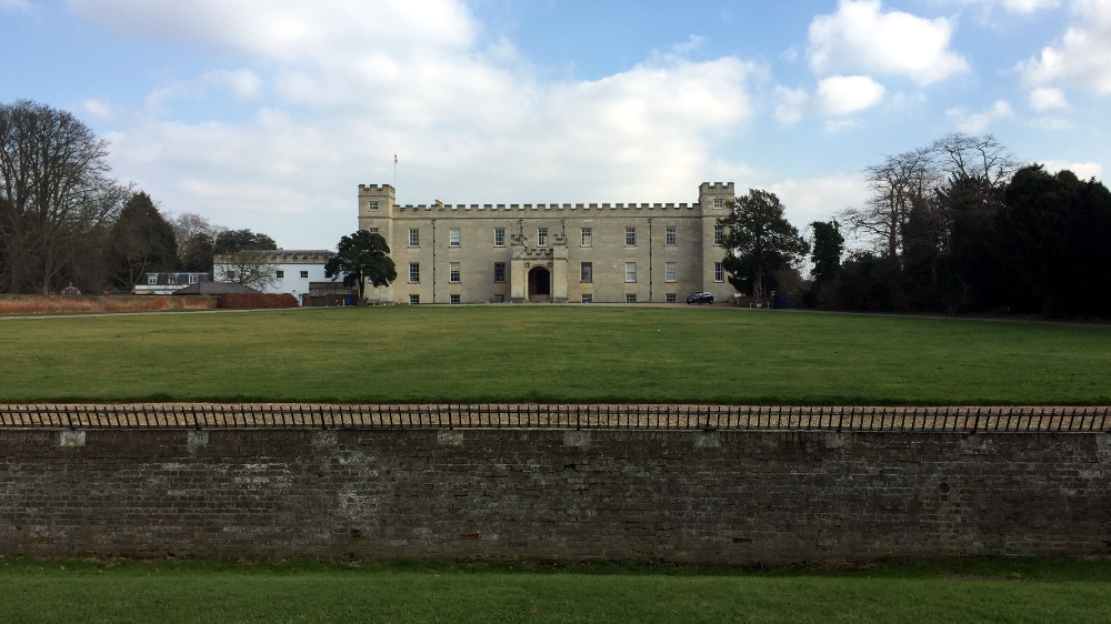
Isleworth village and stately Syon Park with its mansion to Brentford and then along
part of the Grand Union Canal. The section also boasts the densest collection
of major heritage features on the entire trail and as a result this post is
abnormally long even by the standards of this blog.
I’ve combined two official sections again to create a
longer walk, but as the first one includes some of the more rugged walking on
the Ring, you may feel you deserve a rest at the official break point of
Richmond upon Thames. Once you reach the Thames, though, the going is much
flatter and easier. There are various bus stops along the way and another
station close to the trail at Brentford, not far from the end, but also some
longer stretches away from transport options through the commons and the royal
park.
Wimbledon Park
 |
| Wimbledon Park Lake, brought to you by the ever-busy Capability Brown. |
Wimbledon boasts one of the most internationally
recognised names of any London suburb, for two reasons: tennis and wombles,
both of which I’ll have more to say about later. But for most of its existence
it was a relatively unimportant place. The name is probably Saxon in origin,
meaning ‘Wynman’s hill’. There are prehistoric remains in the area, and an
ancient trackway likely passed through to the ford at Kingston upon Thames. Wimbledon
doesn’t merit its own entry in the Domesday survey of 1086, because back then
its land, along with that of neighbouring Putney, was included in the much
bigger manor of Mortlake, in the old Surrey hundred of Brixton. This at one
point was claimed by the ambitious Bishop Odo, mentioned many times in London
Underfoot, but quickly passed into the hands of the archbishops of Canterbury.
Wimbledon appears to have become a separate manor by 1328 but
remained in the control of the archbishops until 1536 when then-incumbent
Thomas Cranmer exchanged it with Henry VIII. The king gave it to another of his cronies,
chief minister Thomas Cromwell, who was born in Putney – historically a part of
the parish until relatively modern times. There were numerous subsequent
owners, including royalty, then in 1717 it was bought by one of the directors
of the speculative South Sea Company, Theodore Jannsen, who was forced to sell
it just six years later after that company collapsed in the infamous ‘South Sea
Bubble’ incident.
The estate was snapped up by Sarah Churchill, the Duchess
of Marlborough, one of the richest and most influential women of her age. This
is how Wimbledon came into the hands of the aristocratic Spencer family, whom
we’ve already encountered in Wandsworth in
section 5. They formally remained lords
of the manor of Wimbledon until 1996 when the title was sold to an un-named
Brazilian for £171,000 – an extraordinary sum given that all property and
rights in the area had long since been sold or relinquished and the status was
purely honorary.
As often in London, the mediaeval geography has been
skewed by the railway. The original village centre was atop a hill to the south
of our trail, around the Green and on the edge of the common. The manorial
centre was close to St Mary’s Church nearby: the original manor house was
probably the building now known as the Old Rectory, dating from the early 16th
century and still standing behind the church.
It was often occupied separately
from the estate: Elizabeth I gave the house but not the manor to her close
adviser Christopher Hatton, who lived at what’s now Hatton Garden off Holborn,
in 1576. He immediately sold it on to the politician and military leader Thomas
Cecil, who later built an entirely new manor house on a grand scale nearby. This
house was subsequently rebuilt completely three times before being demolished
in 1949: the site is now a school playing field. The London and South Western
Railway, opened in 1838, ran through the rather easier terrain at the bottom of
the hill to the southwest, eventually prompting the development of Wimbledon
Broadway, the busy commercial centre around today’s Wimbledon station, some
distance off our route.
Wimbledon Park was once the estate’s private parkland.
Cecil added a deer park and 8 ha of formal gardens to his new house, and
diarist and gardener John Evelyn had a hand in remodelling these in the late 17th
century. Churchill’s great-grandson John Spencer, the first Earl Spencer, expanded
the park and grounds to 480 ha, and in 1765 commissioned the celebrated
landscape gardener Lancelot ‘Capability’ Brown (1716-83) to redesign them.
The
Spencers sold the property in 1846 to an insurance magnate, John Augustus
Beaumont, who soon began parcelling off portions of the park for housing
development. At first, large upmarket houses were built but many of these have
since been demolished and replaced with smaller houses and flats. The remaining
park was briefly a potential candidate for a new site for the Crystal Palace,
though as we saw in
Ring 3, this eventually went to Norwood. The opening of Wimbledon
Park station on the Wimbledon and Fulham Railway, as described in
Ring 5, accelerated
the emergence of today’s Wimbledon Park residential area.
Wimbledon Borough Council, one of the predecessors to
today’s London Borough of Merton, bought a portion of still-undeveloped
parkland in 1915 as a green lung for the increasingly densely-populated area. While
part was turned into today’s
public park, the substantial western portion was
leased to the Wimbledon Park Golf Club. This section remains in use as a
private golf course, though Merton sold it on in the 1990s to the All England
Tennis Club, of which much more later. In recent years the tennis club has been
attempting to buy the golfers out of their lease, which runs to 2041, so it can
further expand its already extensive facilities in the area.
In recognition of their history and remaining heritage
features, both park and golf course are included on the Register of Parks and
Gardens: a heritage trail in and around the site points out some of these
features with informative plaques. There’s a keen local
Heritage Group too,
protecting both the historic features and the present-day amenities of this
popular local park, also the site of one of London’s biggest fireworks displays
every November.
The Capital Ring enters from Home Park Road at Heritage
Trail point 1, where a grand stone balcony provides a viewpoint over the
eastern section of the park. Most of the built facilities are clustered at this
end: you can see the old paddling pool, as well as a new pool, playgrounds and
tennis courts. The steps descend past a recently-restored early 20th
century pavilion, now used by the local police. The proximity to the All
England Club is already evident: alongside the Ring waymarks are others
illustrated with crossed tennis racquets indicating the walking route from
Wimbledon Park station to the club. It’s best to avoid walking this section
during the Championships fortnight, usually in early July, not only because of
the increased footfall but because much of the park is converted into temporary
car parks.
A little further and just off the trail to the right is
the Café Pavilion, likely built in the 1920s at the same time as the tennis
courts and still functioning as a café. Astonishingly a recent masterplan for
improvements to the park proposed to demolish this, but it appears to have been
saved for now. You soon reach the side of the lake, the most prominent of the
features created by Lancelot Brown in the 1760s.
The path here runs atop the dam
built by Brown to trap the water from two streams, now running almost entirely
underground. These rise on Wimbledon Common, merge in the park and drain into
the river Wandle at Earlsfield: the lower part of this watercourse once formed
the boundary between Wandsworth and Wimbledon. The lake is now used for sailing,
and you pass the 1960s watersports centre before turning away from the
waterside to circumnavigate another 20th century addition, the Wimbledon
Park Athletics Stadium. About halfway along, you cross the boundary following
the old streams and re-enter Wandsworth, though the park is entirely managed by
Merton so there’s no evidence on the ground.
The surroundings here are mainly open grassy sports
fields, but ahead and right there’s a view of a small woodland, Horse Close
Wood, which predates the mid-18th century work and is now an
important nature site. The Ring leaves the park through the main entrance onto Wimbledon
Park Road: look out here for Heritage Trail point 8, marking one of the best
viewpoints back over both the public park and the golf course. From here you
can see the contours of Brown’s landscaping, and rising above it on the far
side, the spire of St Mary’s church marking the old manorial centre.
The tennis capital
 |
New Zealand's Tony Wilding in the process of beating Beals Wright of the US at the 1910 Wimbledon men's final.
Pic: Wikimedia Commons |
Unless and until the golf course is handed over, the
All England Club is off the trail, but if you want to see the place where the
world’s most famous tennis tournament is played, it’s only a little further
along Church Road (and back into Merton) from where the Ring turns off along
Bathgate Road. The most obvious visible buildings in this extensive complex are
the two oval stadia of No 1 Court, opened in 2013, and Centre Court, built in
1922 though enlarged several times and with a fully retractable roof added in
2009. While the overwhelming focus of activity here is the two weeks of the
Championships, it’s used as a members’ club throughout the year, with
occasional competitive fixtures such as Davis Cup matches. For those with a
specialist interest, there’s a
Lawn Tennis Museum open daily, a souvenir shop,
and a guided behind-the-scenes tour.
Interestingly, Wimbledon’s roots as the world capital of
tennis are in a completely different sport. The club was founded in 1868 as the
All England Croquet Club, by six members of the team behind The Field magazine who leased a meadow
off Worple Road, southwest of Wimbledon station, as their first ground. Croquet
today is regarded as a rather obscure and eccentric game, but in the 1860s it
was a fashionable craze, thus Lewis Carroll’s surreal version of it in Alice’s Adventures in Wonderland (1865).
The club management, doubtless aware that crazes often decline as quickly as
they arise, diversified in 1875 by setting aside space for lawn tennis, then in
the process of emerging as an adapted and simplified version of so-called ‘real
tennis’, a much older game dating back at least to mediaeval France and once keenly
played by Tudor royals. Tennis soon eclipsed croquet, and since 1899 the club’s
full title has been the All England Lawn Tennis and Croquet Club. The latter
game is still played but on a much smaller scale than tennis, since 2007 at a
separate ground in Roehampton.
From its early days the club raised funds by organising
croquet tournaments and in 1877 it applied the same approach to tennis. This
first iteration of what became the Championships involved 22 male players in
singles matches only. As the rules of the game weren’t yet standardised, the
club issued its own rulebook, only finally superseded by the International
Tennis Federation rules in 1924. Around 200 spectators paid 1s (5p) each to witness
the final between Spencer Gore and William Marshall. Gore, who lived nearby and
much preferred playing cricket, won 6-1, 6-2, 6-4, then told the press that
“lawn tennis will never rank among our great games.” Women’s singles and men’s
doubles were added in 1884, women’s and mixed doubles in 1913.
By then, defying Gore’s prediction, tennis had become
hugely popular, and the increasing numbers wanting to see top players like Suzanne
Lenglen, known in her native France as la
Divine, forced the club to find a new site. It moved to its current corner
of the former Wimbledon Park in 1922, though some of the courts it left behind
at Worple Lane are still there today. The new No 1 Court, closest to the Ring,
is on a portion of land added in 1967 with the absorption of the New Zealand
Sports & Social Club, known as Aorangi Park from a Maori name for Mount
Cook meaning ‘cloud piercer’. Wimbledon’s growth into the phenomenon it is
today, though, really dates from the following year, when restrictions on
professional players competing in the big tournaments were removed. It’s now one
of the four international ‘grand slam’ contests offering the biggest prize
money, and the only one of these still played on grass.
Though the tennis scene has evolved hugely from its
genteel Victorian origins, the whiff of upper class privilege still hangs about
the game. The legacy of the sporting gentleman founders is preserved at
Wimbledon not just in some of its rather stuffy traditions such as the
consumption of strawberries and cream (spectators got through 34,000 kg and
10,000 l respectively in 2017) and the insistence on players wearing whites,
but in its secretive and exclusive structure as a private club with less than
400 carefully selected members. Black players weren’t permitted until 1951 and
Jewish players had to wait until the following year. Women’s prize money was
lower than men’s until 2007. Angela Buxton, joint women’s doubles champion and
singles finalist in 1956, alleged in 2004 that antisemitism had kept her on the
membership waiting list for decades.
Back on the Ring, Bathgate Road and Queensmere Road follow
the boundary between Merton to the south (left) and Wandsworth. The tennis
courts in the triangle where these streets divide inevitably also belong to the
All England Club and are used as practice facilities during the Championships:
you can sometimes spot well-known players using them. Further on are numerous
upmarket residences, including Queensmere House, once part of Southlands
teacher training college but converted to luxury flats in the 1990s, and a 21st
century apartment block built after seven separate owner-occupiers of
consecutive houses on the south side agreed simultaneously to sell up to a
developer.
Wimbledon and Putney Commons
 |
| Putney Heath. |
The adjacent open spaces of Wimbledon Common and
Putney Heath between them cover just under 450 ha, making them about 40% bigger
than Hampstead Heath. The area is one of London’s most valuable green assets,
with terrain that varies from a high and open plateau topped with gravels,
giving rise to heath and acidic grassland, to thick woods that sprout from the
clay lining the valley of the Beverley Brook in the west. Half the heathland
left in London can be found here, which is one of the reasons why around 364 ha
are a designated Site of Special Scientific Interest and European Special Area
of Conservation.
Ling and bell heather grow on the dry heath, with reeds
and rushes in damper areas. Around 100 species of birds can be seen, a
remarkable number for an urban area, including kestrels and a pair of breeding
skylarks, while badgers and various bats are perhaps the most notable mammals. 30
species of butterfly, over 500 of moths and 20 of dragonflies and damselflies
have been recorded. The common is noted as an important habitat for stag
beetles, which can grow to 75 mm long, and the globally rare false click
beetle. There have even been reports of sugar gliders, small arboreal
marsupials native to Australia, with membranes between their limbs that help them
glide between trees: presumably they arrived as escaped or dumped exotic pets.
Among the large mammals listed on the
Commons Conservators website is the extremely local speciality
Womblus
commonus subsp. Litterpickerus, though in truth you’ll find these harder to
spot than the sugar gliders. The wombles, secretive, long-lived, pointy-nosed
and highly intelligent tunnelling creatures, are the fictional creation of children’s
author Elisabeth Beresford (1926-2010), who got the idea when, during a walk on
the common, her young daughter mispronounced the name as ‘Wombledon’.
Beresford
published five novels and a short story collection between 1968 and 1976. The
fame of her creations and of their southwest London home was boosted further by
a stop-motion animation TV series narrated by Bernard Cribbins, made between
1973 and 1975, with a revived version in 1996. Created at a time of rising
environmental concern, the wombles spend their days gathering and recycling rubbish
left behind on the common by humans, and in the books it’s revealed they have a
sixth sense for green spaces. They would be perfect mascots for a green
capital, though I do wonder if any child ever deliberately dropped litter here just
so Orinoco or Wellington had something to pick up.
Like most of the surrounding area, the wombles’
magnificent habitat could so easily have been lost for good in the second half
of the 19th century. Thankfully it was protected from development by
legal action, and since 1871, Wimbledon Common and Putney Heath have been owned
and managed by the Wimbledon and Putney Commons board of conservators, who also
look after the separate and much smaller Putney Lower Common, off our trail to
the north. The joint management of the two adjacent open spaces, each in a
different London borough, reflects their shared history.
As mentioned above, in mediaeval times both Wimbledon and
Putney were part of the large parish of Mortlake and among the estates of the
Archbishops of Canterbury. The modern green spaces are the surviving remnants
of the extensive parish common lands, where local people had the right to graze
cattle, gather fuel and food and dig gravel between Michaelmas (28 September) and
Lady Day (25 March).
Putney, with its important ferry crossing and later bridge
across the Thames in the north, gradually assumed its own distinct identity
centred on a busy riverside town. By the 15th century, it had its
own manorial estate, Putney Park, excluded in 1548 when Wimbledon manor was
given to Thomas Cecil by Edward VI’s regency council. In 1658 Putney briefly
became a distinct parish, and though the parish church reverted to a ‘curacy’
of Wimbledon two years later, the separation of the two areas persisted, even
after John Spencer acquired both the park and the manorial rights to Putney,
including control of commons, to add to his Wimbledon holdings in 1780.
When the territory covered by the Metropolitan Board of
Works was drawn up in 1855, the more urbanised Putney was grouped in with
Wandsworth as part of the ‘Metropolis’ while Wimbledon was excluded. Putney
then went on to become part of London with the advent of the MBW’s successor
the London County Council in 1889, while Wimbledon remained in Surrey (though
in the London postal district and Metropolitan Police district) until the creation
of Greater London in 1965 when it became part of the London Borough of Merton. So
once again the Ring finds itself tracking what was until relatively recently
the limit of the capital.
Spencer and his descendants both exploited and neglected
the commons, authorising illegal encroachments, failing to protect them from
dumping and in 1812 felling all the pollarded oaks to sell for timber. The
Manor Court, which since at least the 15th century had arbitrated
disputes, had become a toothless body. It rapidly acquiesced when the fifth
earl, John Poyntz Spencer, a liberal peer also known as Viscount Althorp, presented
a plan to extinguish commoners’ rights, sell off Putney Heath and use the
proceeds to inclose Wimbledon Common, building himself a new manor house by the
windmill. This, he said, was the best way to manage the “boggy” land with its “noxious
mists and fogs” and to protect it from “great nuisance [that] was caused by
gypsies”.
Spencer reckoned without Henry Peek, one of the new middle-class
residents of the area, a tea and spice trader whose home, Wimbledon House, faced
the common from across Parkside. Peek formed a local opposition group, the
Wimbledon Commons Committee. This in turn influenced the broader-based Commons
Preservation Society, founded in 1865 and now known as the Open Spaces Society,
and the parliamentary enquiry which resulted in the Metropolitan Commons Act of
1866. Meanwhile, as Spencer attempted to advance a private member’s bill
through Parliament to further his plans, the Committee took legal action
against him over the state of the land. The complex dispute continued for
several years, during which Spencer intensified gravel extraction and leased
out land as brickfields and sewage farms.
The situation was resolved with an act of parliament in
1871, which protected the remaining commons and placed them in the care of the
Board of Conservators – but at a price. Spencer was to receive the
then-substantial sum of £1,200 a year to compensate him for loss of earnings,
raised from an additional levy on local property rates. The Spencer family
continued to profit from the commons for the best part of a further century until
the Conservators bought out the annuity in 1968. Today, the Conservators, now a
registered charity, manage the land mainly for informal recreation and
biodiversity, though some of it is allocated to golf courses. Unusually, none
of the board members is a local authority appointee: five are elected by
levy-payers, three appointed by central government departments.
The Capital Ring is usually described as crossing
Wimbledon Common though this is only just true. Its route is almost entirely either
along the historic east-west boundary between the Common, in Merton to the
south (left), and Putney Heath, in Wandsworth to the north, or within the
Putney side. Entering the site from Parkside, the trail is just within Putney, running
through one of the thicker patches of woodland on Putney Heath towards the
cluster of buildings around the famous windmill, where it meets and joins the
boundary at a boundary stone. The buildings themselves are within Wimbledon:
the boundary runs on the path between the café and the car park.
 |
| Wimbledon's landmark windmill, designed by mistake. |
Permission for a windmill was granted in 1817 on the
condition that it provided a public facility. It’s a hollow post mill, common
in the Netherlands but rare in England. This is likely because its builder and
first miller Charles March was a carpenter and not a millwright, and simply
copied a similar mill which once stood on Bankside in central London, without
realising it was of an unusual design. March exploited the high vantage point
by taking a second job as constable, looking out for duellists among other
miscreants. Duelling was technically illegal in England, though still widely
practiced in the early 19
th century, and Wimbledon was a popular
venue for it: in 1798 the prime minister William Pitt the Younger faced William
Tierney, MP for Southwark, in a duel where both opponents missed twice, perhaps
deliberately.
Milling ceased in 1864 when Spencer persuaded the Marsh
family to sell up. To prevent the mill from operating in competition with them
in future, they took the millstones and much of the machinery with them. The
building was used as a family home in the later 19
th century, and
part of it became a
museum in 1975. In the early 2000s the sails were restored
to working order thanks to a Heritage Lottery Fund grant, and the museum
improved and expanded: it’s now open on summer weekends and bank holidays. The grant
also covered improvement to the adjacent park ranger headquarters, including an
information centre which is open daily. The café, known as the Windmill Tea
Rooms, is also well worth a look.
The Ring dips into Wimbledon to pass the clubhouse of the
London Scottish Golf Club behind the windmill. Golf is a Scottish game by
origin so it’s appropriate that there’s a northern connection to the second
oldest golf club in London and the third oldest in England, as well as links to
the use of commons for military purposes, which go back to George III’s time
when it was the site of Royal military reviews.
In 1860 Spencer offered to host
the inaugural meeting of the National Rifle Association, founded as a corps of
volunteers raised to defend Britain from a potential French invasion, with
Queen Victoria firing the first shot. Rifle ranges were a permanent feature
until 1894, when a stray shot accidentally killed a gardener in the adjacent
Putney Vale cemetery, but the commons were used for army training again in both
world wars, and the Ministry of Defence still appoints one of the Conservators.
Soon after 1860, golf-playing members of the London
Scottish Rifle Volunteers dug seven holes on the common. A formal club followed
in 1865: the current clubhouse is the third such building, dating from 1897. A
second club, Wimbledon Common Golf Club, founded in 1908, plays on the same
course but has a separate clubhouse and a different starting hole. Golfers from
both are easily recognised as for safety reasons the Conservators require them
to wear pillar-box red tops.
Downhill through more trees, the trail arrives at Queensmere,
by far the deepest of the nine lakes and ponds on the commons. It was created
to mark Queen Victoria’s diamond jubilee at the end of the 19th
century by damming a stream that crossed a marshy area once popular with
duellists. It’s evolved into an atmospheric, perhaps slightly gloomy place,
surrounded by trees on all sides, with water lilies flourishing in summer and
large tench and pike patrolling the depths. Past the pond and once again tracing
the Wimbledon-Putney boundary, the woods on the right cover the former rifle
butts, then you cross a sandy area on the edge of the golf course that retains
something of a heath-like appearance.
The trail descends again to join a path known as the Stag
Ride. Through the trees here, only a short detour away and on the alternative
Green London Way, is the First World War Memorial, a granite cross encircled by
trees, with the suggestion – presumably unintentional – of an ancient stone
circle. Created in 1925, it bears no names but a lyrical inscription:
Nature provides the best monument. The perfecting of the work
must be left to the gentle hand of time but each returning spring will bring a
fresh tribute to those whom it is desired to keep in everlasting remembrance.
The memorial stands on one of the former fields of
Newlands Farm, part of a 17 ha portion of land acquired by the Conservators in
the 1920s. Most of this, visible through the trees past the memorial, is now
managed as sports fields, named Richardson Evans Playing Fields after someone
who was instrumental in securing the land for public use.
The Ring then meets and briefly follows the Beverley
Brook. The official source of this river is near Worcester Park station, from
where it flows roughly north for 14.3 km via New Malden, Wimbledon Common and
Richmond Park to Barnes. Here it turns east to join the river Thames at Barn
Elms just above Putney. There’s also a substantial tributary, the 5.3 km Pyl
Brook, which rises in Sutton and joins the Beverley at New Malden.
The brook's name harks back to a rural past when it was noted for beavers, but it's now an urban river which has been straightened and culverted in many places. It suffered from
the dumping of poorly treated sewage until 1998 when improvements in water
treatment increased its wildlife. Further restoration is now taking place,
including in Richmond Park. A 10.5 km signed trail, the
Beverley Brook Walk,
was created by the Ramblers and the local boroughs in the early 2000s,
following the brook from New Malden to Barn Elms.
The course of the brook has long served as an ancient
boundary, marking the western edge of Wimbledon and Putney and the Hundred of
Brixton, and large stretches of it still demarcate Wandsworth and Merton from
the boroughs to the east. So when just short of a sports pavilion the Ring
turns left to cross it, you finally leave the commons and Wandsworth for a
brief visit to the Royal Borough of Kingston upon Thames.
Kingston Vale
 |
| Robin Hood Gate, not quite a roundabout. |
The Capital Ring crosses one of the University of
Roehampton’s sports fields to arrive at the busy Robin Hood Gate road junction,
where the A3 Kingston Bypass peels away from the old Portsmouth Road through
Kingston, here known like the district as Kingston Vale. This is the only
interruption of a lengthy stretch of green walking, but it’s now about a
painless as it could be despite the busy roads. A Pegasus crossing – so called as it accommodates horse
riders as well as walkers and cyclists – takes you across the westbound traffic
and onto a teardrop-shaped patch of ground at the apex of the junction.
Despite
its shape, this was treated as a roundabout until 1995 and is still sometimes
called the Robin Hood Roundabout locally. The pipe sprouting from a plinth to
the left is not some strange monument but a sewage vent or ‘stink pole’ for a
pumping station beneath the junction. Then another crossing allows passage
across the eastbound traffic from both the A3 and Kingston, leading straight to
the stump of a street that ends in the Robin Hood Gate of Richmond Park. Until
the early 2010s the only safe way across here was an ugly footbridge which
still stands to the left, so the at-grade crossing is a major improvement.
Kingston Vale today is a sharp triangle inserted between Richmond
and Wandsworth, its point just to the northeast of the junction, where the Beverley
Brook enters Richmond Park. But the historic boundaries were much less angular,
as the land now forming the southern part of the park was also part of the
parish of Kingston upon Thames. As outlined on
London Loop 8, which passes
right through it, Kingston is one of the most historic centres in suburban
London, the place where several Saxon kings were crowned. It was the basis not
only of a large parish but also of one of the Surrey hundreds, bounded by the
brook to the east.
Kingston stood on the major highway between London and
Portsmouth, which branched off Roman Stane Street (crossed in the
last section)
at Clapham. This route only increased in strategic importance as Portsmouth
developed into England’s foremost naval port. The road now known as Kingston
Vale formed a part of the highway, its name distinguishing it from Kingston
Hill, the stretch that climbs the promontory above the Thames where the town
centre stands. The locality was once known as Kingston Bottom, and only adopted
its current name sometime in the 19
th century, presumably encouraged
by developers who favoured something less likely to make schoolchildren giggle.
The original road junction here was a relatively minor one.
It still exists today, a little southwest of where we cross, where Robin Hood
Lane leaves Kingston Vale. The lane was once a farm track leading to Robin Hood
Farm, and by the 18th century a coaching inn known as the Robin Hood
had appeared on the corner, as well as a scattering of houses around both the
junction and the gate into the park. In 1870, to accommodate increasing traffic,
the inn moved to a larger site opposite, on the Richmond Park side of the main
road, with stabling for 30 horses: this building also still stands as Robin
Hood House, converted into flats in 2004.
Kingston had long been known as a bottleneck on the Portsmouth
road, a problem exacerbated by the growth of motor traffic in the early 20th
century. The campaign for a bypass began in 1910, and the road was completed in
1927, by which time it had been designated part of the A3. At 13.7 km, it was
one of the longest bypasses built at the time, leaving the old road here at
Robin Hood Gate and rejoining it at Ditton Common near Esher. It was opened by
the prime minister himself, Stanley Baldwin. Soon more houses appeared
alongside the road and on the surrounding fields, creating the cluster familiar
today. Now regarded as having a particularly attractive mix of architecture
despite the busy junction, the locality has become a designated Conservation
Area.
Stag Lodge Stables, on the right just before the gate, was
known as Parkside until the mid-1960s. Its core is likely 18th
century though its current mock-Regency stucco façades date from a remodelling
in the following century. In the days of horse-drawn transport it was the place
where the ‘cock horse’ was stationed – the additional horse who joined the team
to help haul heavy wagons up Kingston Hill. Its business is still equestrian
but rather more leisure-oriented, as a riding school and livery stables ideally
positioned for both common and park.
Richmond Park
 |
| Pen Ponds, Richmond Park. |
At 955 ha, around three times the size of New York
City’s Central Park,
Richmond Park is the single biggest and perhaps the most beautiful
and valuable public open space entirely in London and the biggest urban park in
Europe. Although there are areas of formal gardens and mown playing fields, most
of it is rough, rugged and astonishingly rural, a rolling expanse of largely
undisturbed acid grassland dotted with lone mature trees, patches of bracken
and small woods. Its character is maintained by the centuries-old practice of
grazing with deer, who roam freely. Most of the park is a designated Site of
Special Scientific Interest (SSSI), in particularly because of its population
of rare beetles that flourish on old dead wood, and since 2000 it’s been a
National Nature Reserve (NNR), one of only two in London (the other, Ruislip
Woods, is on the
Hillingdon Trail).
The story of how this giant patch of urban countryside was
preserved as the well-loved public resource it is today begins, rather
ironically, with the actions of a selfish monarch. In 1625 Charles I took
refuge from an outbreak of plague in London at Richmond Palace and took a
liking to the place, except for one thing: the existing hunting park, in a bend
of the river to the north of the palace, simply wasn’t big enough for him. In
1637 he seized a much bigger portion of land to the southeast as the ‘New Park’,
inclosing it with a 13 km-long wall, much of which still stands today, and
introducing 2,000 deer. Some of this was already in royal ownership and used
for hunting, but the rest was a mix of farmland and common land spanning
several parishes: Ham, Kingston, Mortlake, Petersham, Putney, Richmond and
Wimbledon.
Understandably the King’s action provoked an outcry. He
eventually agreed to compensate local landowners and to create six gates so
that local people could continue to gather firewood and cross the park on
public rights of way rather than making long detours around the wall. This was
only one of numerous issues over which Charles, a fervent believer in the
divine right of kings, clashed with his subjects and undoubtedly added to his
declining popularity. His repeated conflicts with both the English and Scottish
parliaments eventually provoked revolution and civil war. Following the
establishment of the English Commonwealth, so far the only republic in mainland
Britain, the king was executed for high treason in 1649.
Richmond Park was vested in the City of London during the
Commonwealth period, on the basis that it would be “preserved as a Park still,
without Destruction; and to remain as an Ornament to the City”. It was returned
to royal hands following the restoration of the monarchy in 1660. The idea of
the park as an ‘ornament to the City’ was challenged again in 1751 when George
II’s daughter Amelia was appointed ranger. She claimed the park as her personal
pleasure ground, locking all the gates and only permitting entry to the select
few. Several years of both legal moves and direct action followed: the vicar of
Richmond defiantly led his parishioners through holes in the wall so they could
complete the annual Beating the Bounds ceremony.
In 1755, a Richmond brewer, John Lewis, followed a
carriage through the Sheen gate and, when challenged, insisted on his right to
walk through the park. Forcibly expelled by the gatekeeper, Lewis went to court.
Doubtless nervous of provoking Royal irritation, the Surrey Assizes found reasons
to delay hearing the case, and there was an attempt to discredit Lewis by associating
him with a seditious pamphlet.
But growing public support finally forced the
issue, and in 1758 the justices found in his favour. The princess reluctantly installed
ladder stiles but placed the rungs so far apart only the most athletic adults
could use them, and Lewis had to return to court to get this fixed. The
financial burden, combined with a flood in his brewery, reduced him to penury,
and he lived for several years until his death in 1792 on a modest annuity
established by grateful locals. He’s buried in Richmond church.
Amelia, now bored with the park, resigned her post as
ranger in 1761, and the access regime relaxed again, although for many years
carriage drivers had to obtain special tickets and walkers were restricted to a
few well-defined rights of way. Under Queen Victoria in the next century, the official
view of the Royal Parks in London gradually shifted from private playground to community
asset, culminating in the Parks Regulation Act of 1872 which provided for their
management as public open space. An essay on Lewis by Max Lankester of the
Friends of Richmond Park speculates that without him, political and social
changes would eventually have led to the reopening of the park, but perhaps not
for another century. “The determination and shrewdness of John Lewis remain a
landmark in the Park's history, and worthy of being celebrated,” concludes
Lankester.
The job of looking after Richmond and the other Royal
Parks passed to the government, which in 1993 created the Royal Parks Agency to
manage them. As part of the contemporary mania for disposing of such state
responsibilities, this was succeeded by an independent charity in 2017, though
the land itself is still Crown property. Meanwhile the elision of the historic
boundaries within the park walls was made official in 1890 when the entire site
became part of Richmond municipal borough, the predecessor of the London
Borough of Richmond. The park had its own constabulary until 2005 when it was
merged with the Metropolitan Police.
Robin Hood’s Gate is one of the six original gates in
Charles I’s wall. It was rebuilt in the 1780s to designs by John Soane, though
widened in 1896 and again in 1907 to admit motor vehicles, which inherited the
right to pass through the park on certain routes originally established for
horse-drawn transport. Today the intrusion of traffic is seen as unwelcome, and
although there are a couple of through-routes still in use during daylight
hours, this gate was closed to motor vehicles as part of a raft of reduction
measures in 2003. A round-the-park walking and cycling route, the
Tamsin Trail, crosses here.
The Ring avoids the surfaced drives and heads instead up
the flank of a grassy slope, atop which is Spankers Hill Wood. Like many of the
woodlands in the park, this is a relatively recent plantation, created in two
stages in 1819 and 1824 – as deer graze tree bark and destroy saplings, the
reintroduction of woodland areas had to be managed carefully. Beyond the next
car park with its popular refreshment kiosk, another woodland, the King George
V Plantation, is to the left. As its name suggests, this is more recent,
planted to commemorate the silver jubilee of the titular monarch in 1935: he
died the next year. Far over to the right you might glimpse White Lodge, a
Grade I listed hunting lodge built for George II in 1730, and where Edward VIII
was born (I said a bit more about him in connection with a rare pillar box on
section 3). It’s now occupied by the Royal Ballet School.
You’re now on a broad stony track that soon follows the
causeway between two of the park’s most striking features, the twin Pen Ponds,
which between them occupy 12 ha. Fed by various streams, these were dug for
George II in 1746 and are shown on a 1777 map as ‘canals’. They have functioned
as fishponds and as part of drainage systems as well as decorative features and
are still used by anglers in season. They were temporarily drained during World
War II to make them less obvious a navigation aid for enemy pilots.
It’s at this point, walking between placid ponds set among
a vast expanse of rolling grassland punctuated by raggedy woodlands and clumps
of trees, that you might well have to remind yourself you’re really still in
London. Traffic noises from the surrounding roads have almost entirely faded
away, and all is quiet except for the planes passing overhead on their way to
Heathrow. Your sense of isolation might be reinforced in winter by the chilly
temperatures: the ponds lie in a notorious frost hollow and regularly freeze
over. The feeling persists as you climb the slope beyond the ponds, with the
much smaller Leg of Mutton Pond over to the left, then cut across the rough grass
towards Sidmouth Wood.
This is one of the most likely places on the trail to spot
the deer. There are now around 630 of them, some with an ancestry that predates
Charles’ inclosure, with two distinct species. Fallow deer, tan in colour and
often with a distinctive dappling of lighter spots, were introduced to Britain
in Norman times and are now the most widespread. The larger red deer, with a
reddish-brown coat, are a native species, the island’s largest land mammals. To
regular park users, the deer are familiar and even seem tame, but the Royal
Parks are keen to remind people they’re wild animals, so keep a distance of at
least 50 m and consult the official safety advice before taking a dog. You’ll
need to take special care in the rutting season in September and October, when
the males compete aggressively for females, and the birthing season of May to
July when the females are protective of their young.
Another, more controversial, seasonal issue affecting the
deer is the regular cull. Left to their own devices in this enclosed space, the
herds would rapidly expand to unsustainable levels, with severe consequences
both to the health of the animals themselves and their environment. So park
rangers selectively kill deer by shooting them through the head, the males in
February, the females in November, with temporary closures of park gates,
usually at quieter times. There’s considerable opposition to this practice, and
calls to use contraception instead, but park managers insist they continue to
review all options and no other alternative is currently practical. Contraception
couldn’t be administered reliably except by injection, involving rounding up
the deer and subjecting them to severe stress and injury.
At a complex junction of paths by the fence around
Sidmouth Wood, you can see a large fenced-off oak tree just to the left: this
is the Richmond Royal Oak, one of the Great Trees of London designated by Trees
for Cities. The woodland on the other side is the largest of the park’s 19th
century plantations, dating from the 1820s. It’s named after politician Henry
Addington, 1st Viscount Sidmouth (1757-1844), who was deputy ranger
at the time, and had been prime minister between 1801-1804.
When the trees aren’t in leaf on the left, you’ll catch a
glimpse of one of the oldest buildings in the park: White Ash Lodge, an
unpretentious brown brick house dating from the 1740s. This is currently rented
out as a private house, surely one of the most exclusive addresses in London.
Then you follow part of the drive of Oak Lodge, built within the plantation around
1852 as a home for the park bailiff and now a base for the park rangers. It’s
rather curiously named, as its woodland surroundings consist of rather more
chestnut than oak.
Around Pembroke Lodge
The Ring arrives on Queen’s Road, a remaining
traffic through route along one of the old rights of
way. You’re within sight
here of Pembroke Lodge, surrounded by public gardens with numerous features of
interest. If you stick rigorously to the official route, you’ll dodge entirely
around them, but there are options to dip in and out of it via gates, or you
can use the alternative Green London Way instead, which goes right past the
lodge itself and up King Henry’s Mound. If you’ve never visited the park
before, I highly recommend a detour. An adjacent refreshment kiosk and a
Friends of Richmond Park information centre also provide a convenient pitstop.
The lodge is on the site of a much-humbler dwelling. In
1754 a cottage known as Hill Lodge was built here to house the park
molecatcher, a position created in 1702 after William III had a riding accident
in the park, falling and breaking his
collarbone when his horse tripped on a mole tunnel. Complications from the
fracture ultimately caused the king’s death from pneumonia. The prime location
at the highest point in the park, overlooking the Thames valley, later caught
the attention of Elizabeth Herbert, Countess of Pembroke and Montgomery. She
persuaded George III to grant her the site, and commissioned John Soane to
design a painted brick mansion, completed in 1796.
Victoria later granted it to Whig prime minister John
Russell, in office 1865-66, and his grandson, the philosopher Bertrand Russell
(1872-1970) grew up here. Actor David Niven knew the place when it was the
headquarters of his regiment, the GHQ Liaison Regiment, a specialist army reconnaissance
and intelligence unit, during World War II. It’s currently leased by a private
company and used as an upmarket tea room and events venue. 5 ha of landscaped
formal gardens around the buildings house a monument to the Russells and the
grave of a dog belonging to a later resident, the Countess of Dudley.
King Henry’s Mound, to the north, may well be a Bronze Age
burial chamber and was used as a lookout in hunting park days. On 17th
century maps the site was marked as King’s Standing, though the tradition that
Henry VIII stood here to observe a rocket fired from the Tower of London
confirming the execution of his second wife Anne Boleyn almost certainly has no
factual basis.
Since 1710 the mound has provided a ‘keyhole’ view of the
dome of St Paul’s Cathedral in the City, with a tree-framed sightline carefully
preserved by landscapers through the centuries. As one of the protected views
of the cathedral, it can’t legally be obstructed, but a 143 m residential
block, the Manhattan Loft Gardens building, is currently under construction in
Stratford immediately behind it. Whereas previously the dome stood out against
an empty sky, now it’s backed by a modern geometric skyscraper. To anyone with
any degree of aesthetic awareness, the result is almost as bad as the view
being blocked entirely, yet supposedly nobody thought of this before the new
tower was authorised.
Your mind might turn to reasons to be more cheerful if you
explore further north of the mound, following the rose arbour to Poets Corner,
a pretty landscaped garden with views towards the Thames. This began in 1851 as
a simple memorial board attached to a tree nearby, dedicated to the Scottish
poet James Thomson (1700-48), best known for his series of poems The Seasons and the text of ‘Rule
Britannia’, who died in Richmond. In 1895 the Selbourne Society installed the
first version of the current board on its present site.
Today’s visitors are perhaps more familiar with the
subject of a second memorial here, the singer, songwriter and actor Ian Dury (1942-2000),
commemorated by a bench designed by Mil Stricevic and installed in 2012. Dury
regularly visited the park with his children and favoured the view from here.
The bench is equipped with a solar-powered digital player so visitors can plug
earphones in and listen to songs and an interview, though like many such
features its performance over the years has been erratic. More enduring is the
text “Reasons to be Cheerful” carved into the backrest, and if you need
reminding, here are a few:
Summer, Buddy Holly, the working folly,
Good golly Miss Molly and boats,
Hammersmith Palais, the Bolshoi Ballet,
Jump back in the alley and nanny goats,
18 wheeler Scammels, dominica camels,
All other mammals plus equal votes,
Seeing Piccadilly, Fanny sniffing Willie,
Being rather silly and porridge oats.
Petersham
 |
| The view from Petersham Park. |
As previously mentioned, the Ring avoids the lodge,
heading straight across the drive and passing a gate into the gardens on the
right. Then it’s through another gate into a separate area of the park known as
Petersham Park, following a path that curves around the western perimeter of the
gardens, with the ground falling away steeply to the river Thames on your left.
The views from here across the broad valley are exhilarating. Most prominent
are the two rugby stadia in Twickenham, the main Twickenham Stadium, known as
the ‘Cabbage Patch’ and home to the England team, and the smaller Twickenham
Stoop, where the Harlequins are based, but you might even be able to spot
Windsor Castle on a good day.
This part of the park was once common land in Petersham manor
and included a manor house. Soon after Charles I’s land-grab the house, renamed
Petersham Lodge, became the home of one of the park’s deputy keepers, renowned
playwright Ludovic Carlile, whose wife Joan was one of the first women in
England to paint professionally.
Its separate character was reinforced when it
was leased in 1686 to Lawrence Hyde, the Earl of Rochester, who developed it
into a grand estate known as New Park. Rebuilt in 1721 by William, Earl of
Harrington, the lodge is referred to by James Thomson, who writes in Seasons of “the pendent woods that
nodding hang o’er Harrington’s retreat”. The house (not the building now known
as Petersham Lodge on River Lane) was derelict by 1835 and was demolished, with
the surroundings incorporated once more into Richmond Park. It was located on
the lower slopes of the meadows but there are no visible remains.
The path reaches a flight of steps on the right, your last
chance to visit King Henry’s Mound and Poet’s Corner. Downhill from here is one
of the steepest, and most precipitous when wet, descents on the whole trail. You
leave the park past a children’s playground and through Petersham Gate, not one
of the originals.
There are records of a manor at Petersham from early in
the 10th century, when it belonged to Chertsey Abbey. It remained
abbey property at the time of the Domesday survey and was only given up in 1415
when the abbot surrendered it to the crown and it was annexed to Richmond. Henry
VIII gave land at Petersham to his fourth wife, Anne of Cleves, as part of
their divorce settlement, and it later passed through several private hands. A
portion further upstream was carved out to become the separate parish of Ham, home
to Ham House, seat of the Dysart family, which still stands and is now owned by
the National Trust. Swathes of both Ham and Petersham were then included in
Richmond Park.
The Dysart Arms pub opposite the park gate was known as
the Plough and Harrow until the early 19th century when it was
renamed after the local bigwigs. The current building is a ‘Brewers’ Tudor’
rebuild from 1904, and the fact that since 2005 it’s been operated as an upmarket
restaurant rather than a pub speaks to the way this corner of an already prosperous
borough has become one of London’s most desirable addresses. Following a
footpath rounding the side of the church, the green Capital Ring waymarks
temporarily replaced by black ones to conform to Richmond’s planning rules,
it’s easy to see why, as Petersham still gives the passable impression of a
chocolate box English village.
 |
| George Vancouver's grave in Petersham church. |
Grade II*-listed St Peter’s Church, described by Nikolaus
Pevsner as “of uncommon charm”, is likely a Saxon foundation, as it’s mentioned
in the Domesday survey. Much of the fabric of today’s building is 16
th
century, with 13
th century fragments in the chancel, and it’s
thankfully avoided the worst excesses of Victorian improvers. Inside are some
18
th century box pews segregated by panelling and intended to allow
families to sit together, a once-common design that is now rare.
There are
numerous memorials and headstones of interest inside and out, including the
grave of explorer George Vancouver (1757-98), who charted the northwest Pacific
coast of North America and gave his name to Vancouver Island and the cities of
Vancouver in both British Columbia, Canada and Washington state, USA. Another naval
explorer interred here is Henry Ligbird Hall, who first charted Lord Howe
Island in the Tasman Sea between Australia and New Zealand in 1788.
A track from the village continues the rural theme by
crossing Petersham Meadows, a remarkable agricultural survival noted among
other things for being painted by J M W Turner in 1815. These water meadows
have been grazed by cattle since at least the 17th century when they
were attached to the Ham House estate. When this was broken up at the end of
the 19th century the fields were threatened with housing
development, but campaigners succeeded in securing parliamentary support for
the Richmond, Petersham and Ham Open Spaces Act 1902 which transferred
ownership of these and several other commons and open spaces to Richmond
council for the purposes of public enjoyment.
Alongside public access, for decades the council continued
to lease the grazing rights to a well-known local dairy firm, Hornby and
Clarke, and when this closed the lease passed to private investors. By the end
of the 20th century, the tenants were becoming reluctant to maintain
grazing on such a small area where there was no longer potential for profit, so
in 1998 local people led by athlete and outdoor enthusiast Chris Brasher formed
the Petersham Trust, dedicated to retaining the ancient practice.
This trust leased
the meadows from the council and began fundraising with the intention of
passing them on to the National Trust with an endowment to ensure grazing
continues, an objective achieved in 2010. The meadows are currently home
between spring and autumn to a small herd of Belted Galloway beef cattle, and
the Trust retains the tradition of paying an annual rent to the council in the
form of a posy of wild flowers.
Before you get too deep into the meadows, look up the hill
on the right for a view of the enormous red brick Grade II-listed Royal Star and
Garter Home, opened in 1924 as a care home for disabled ex-servicemen on a site
donated by Queen Mary. It took its name from the Star and Garter Hotel which
previously stood here. The charity that ran it still cares for forces veterans
and their partners with disability and dementia but moved out in 2013 and now
operates at several other locations with more modern facilities. Predictably,
the original home has been converted to luxury flats.
Richmond riverside
 |
| View towards Richmond Bridge. |
The Capital Ring now reaches the side of the river
Thames in Buccleuch Gardens, merging with the
Thames Path National Trail. From
here it follows the towpath upstream towards central London for around 1.6 km.
As I’m planning to cover the Thames Path in more detail later, I’ll say more
about the Trail and the river then. But take a few moments to think back to the
last time the Ring ran alongside the Thames, where it’s much wider and
beginning to turn estuarine at Woolwich, and the gentler aspect it presents
here as an inland navigation. Note that sections of the towpath may be
underwater during particularly high tides, especially between Richmond Bridge
and Richmond Lock.
A succession of points of interest lines this stretch.
Buccleuch Gardens and its much bigger sister, Terrace Gardens, on the other side of
Petersham Road to the right, are the remains of another aristocratic estate. The
land was once part of the common attached to Richmond manor, and in the 1630s
the slopes were peppered with tile kilns making use of clay dug from the
hillside. In the 1760s George Brudenell, Earl of Cardigan and Duke of Montagu,
built a riverside mansion on the site where a brick shelter now stands, just as
the trail reaches the riverside.
The Duke began acquiring land on the other
side of the road to extend his private gardens up the hill, linking the two sides
with a barrel-vaulted subway in the style of a grotto, still open today and a
little further along the trail. The estate passed by marriage to the Dukes of
Buccleuch who in the mid-19
th century entertained visiting royalty
here, including Queen Victoria and Prince Albert, Leopold I of Belgium, and the
Ottoman Sultan Abdülaziz I.
The Buccleuchs sold Terrace Gardens to the parish vestry,
predecessor of the Metropolitan and London boroughs, in 1886 for use as a
public park, but Buccleuch Gardens remained private property until 1937 when it
was bought by Richmond council. The house was demolished soon afterwards,
although some of its arcades are still visible, and replaced with the current
shelter. Both sites are on the Register of Historic Parks and Gardens and
enjoyed a major refurbishment in 2009, so it’s well worth a detour via the
grotto for a more detailed exploration.
The building with the three pitched roofs visible to the
right just after the gardens is the Three Pigeons, a residential rebuild of an
old pub that burned down in 1993. You then pass the boathouse of Richmond Canoe
Club, founded in 1944, with the distinctive curved roofs of modern Blade House above.
Then there’s
Riverdale Gardens, a small park on the site of a house of that
name which had been demolished by 1930. Past this are the backs of the remaining
buildings of what was once a spectacular 1720s terrace called the Paragon.
Stein’s restaurant with its terrace is on the site of the
Lansdown Brewery, founded sometime before the 1880s and closed in 1915: the
brewery stores still stands, fronting onto Petersham Road. There were once
several breweries along the riverside here, including the one belonging to
Richmond Park access campaigner John Lewis, mentioned above. While the danger
of flooding was ever-present, the river provided both power and a convenient
way of getting ingredients in and beer out: contrary to popular opinion,
breweries would not have sourced their brewing liquor from the already-polluted
Thames.
The next small garden is known as the
Gothic Garden, after
Gothic House, part of the Paragon but demolished for road-widening in 1938. Another
Great Tree of London, the Richmond Riverside Plane, the tallest of its species
in the capital, stands in the garden of Gaucho’s restaurant. Just past this is
Richmond Landing Stage: from spring to autumn boats leave from here to Kew
Gardens and central London as well as upriver to Hampton Court.
Rotary Gardens,
further along, is on part of the grounds of a Queen Anne house, Northumberland
House, demolished in 1969. Moored here is a historic Thames lighter, the Duke
of Cambridgeshire, built around 1900 and now home to a social enterprise, the
River Thames Visitor Centre, open daily with exhibitions, information and a
café. The smaller flats downstream of this are on the site of the old house.
Finally, you reach
Bridge House Gardens, on the site of
another vanished house built in the 1690s. In the early 20
th century
it was a fashionable riverside tea room but had become derelict by 1959 when it
was largely demolished to make way for the current park. A fragment of its
lower level survives as part of the Tide Tables Café, the main part of which
occupies some of the arches of Richmond Bridge. A bust overlooking the gardens
commemorates Bernardo O'Higgins Riquelme (1778-1842), leader of the
revolutionary movement that freed Chile from Spanish rule in 1818 and the
country’s first Supreme Director. He lived in Richmond while a student in the
1790s.
Richmond Bridge, opened in 1777, is the oldest bridge
across the Thames in London still in use. There are several older crossing
points where the current bridges are more recent, but Richmond still retains
its initial structure. The bridge was widened and its hump reduced in 1937 and
you can spot the join as you walk under it, but the original Portland stone facings
were replaced to keep the historic appearance.
The bridge answered a growing need for a more reliable
crossing point in this developing part of the capital than the existing ferry,
which was regularly disrupted by flooding and high tides. In 1774, with the bridge
already under construction, the novelist and Whig politician Horace Walpole,
who lived at Strawberry Hill House on the Twickenham side, wrote to a cousin
who had served in Austria that after a month of rain:
The Thames is as broad as your Danube, and all my meadows are
under water…The ferry-boat was turned round by the current, and carried to
Isleworth. Then we ran against the piers of our new bridge.
The bridge cost £26,000, raised from private shareholders
who earned profits for life on tolls charged to cross it. The last of the
investors died in 1859, having spent her last years living comfortably on an annual
income of £800 from tolls, at which point the crossing became free.
Past the Richmond Bridge Boathouses, where master
boatbuilder Mark Edwards perpetuates this traditional riverside industry, you
reach what at first glance appears to be a preserved Georgian square
surrounding a series of grass terraces and steps descending to the towpath. But
a closer look reveals that, though a few of the buildings are genuinely old,
much is modern pastiche. In places you can even spot the false ceilings through
the Georgian-style sash windows. This is the controversial Richmond Riverside
development masterminded by architect Quinlan Terry in the late 1980s, praised
by some, including Prince Charles, derided by many others who dismiss Terry as
“the Andrew Lloyd Webber of architecture.”
 |
| Richmond Riverside: contemporary architecture's answer to Cats? |
The oldest buildings, all Grade II-listed, are the ones just
downriver from the bridge, though they’ve been altered as part of the
redevelopment. The one-bay Tower House, immediately above the boathouse and
easily recognisable from the Italianate belvedere that explains its name, dates
from the mid-19th century. The next bay, also with a terrace above
the boathouse, is the Royal Family Hotel, built in 1820.
Above the grassy
terrace and in a similar style is the Palm Court Hotel: built in the 1850s, it
absorbed its smaller neighbour in 1947. To the left (upstream) of the archway
is the oldest building in the group, red brick Heron House, built in the early
18th century though extended several times. Hotham House next door
is perhaps the most egregious modern fake, borrowing the name of a 17th
century building on the site which collapsed in 1960. The war memorial to its
left is an original feature from the 1920s.
A century ago the hotels lived up to their names, with
their suggestions of elegance and luxury. The grassy slopes were then private
terraces and you can just about imagine them populated by Edwardian
sophisticates sipping cocktails rather than the boozy crowds that now spill out
of the Pitcher and Piano. By the 1970s, though, the area was decayed and partly
derelict. In 1975, a group of campaigners led by writer and activist Erin
Pizzey squatted the Palm Court to set up one of the earliest refuges in the UK
for women victims of domestic violence. Today, when developers seize on any
available riverside property for conversion to prestigious offices,
unaffordable flats and globalised catering chains, it’s hard to imagine a
London in which properties like this could be put to such informal and socially
valuable use.
The white riverfront buildings further on are also fakes,
but Riverside House and the stock brick warehouse on the corner of Water Lane
are older: the latter dates from the 18th century and is Grade
II-listed. They were once part of another brewery, Collins, which operated
between the 1720s and the 1870s, after which the warehouse, slightly
ironically, housed a municipal waterworks. The picturesque lane led to the
ferry departure point, in operation from at least Norman times until the bridge
opened. For most of this time two boats were used, a smaller one for passengers,
and a larger one for horses and small vehicles: the steep incline on the
Twickenham bank precluded larger carriages and carts. A slipway here still
provides river access.
The White Cross, also Grade II listed, was originally
known as the Watermans Arms and was the Collins brewery tap. The current building
is an 1835 rebuild with an additional storey added in the 1860s. It overlooks
St Helena Pier, from where Turks Cruises sail upriver to Kingston and Hampton
Court. The pier takes its name from the adjacent St Helena House with its
terrace and boathouses below, built in 1837 for Collins. Section 6 of the Ring
ends where Friars Lane reaches the riverside, with a signed link to Richmond
station: Section 7 simply continues along the Thames Path, but even if you’re
not breaking your journey here, it’s worth wandering a little away from the towpath
to explore Richmond’s historic heart.
Richmond Green and Palace
 |
| Asgill House with its ex-Great Tree of London. |
Richmond’s full name is Richmond upon Thames, to
distinguish it from the other Richmond, a market town in Swaledale, North
Yorkshire, on the edge of the Yorkshire Dales National Park. The duplication of
names is not coincidental. Until 1501, our Richmond was known as Sheen, meaning
‘shelter’, a name that survives in the adjacent neighbourhood of East Sheen. The
village and its ferry likely grew to serve the palace which existed here for
many centuries as one of a chain of royal residences along the river.
Sheen
isn’t listed in the Domesday survey and there’s no clear record of when the
palace was first built: the first mention of royal use is by Edward I in 1299. Richard
II had it destroyed out of grief for his deceased wife Anne of Bohemia, who
died here in 1394, but it was rebuilt by Henry V a couple of decades later as
part of a project known as the King’s Great Work. This also ultimately led to
the creation of Syon Park, of which more later.
The English aristocracy spent most of the second half of
the 15th century locked in a bitter power struggle known as the Wars
of the Roses between the houses of Lancaster and York. At the Battle of
Bosworth Field in 1485, the reigning monarch, the Lancastrian Richard III, was finally
defeated by Yorkist forces led by challenger Henry Tudor, who took the throne
as Henry VII. Henry was the Earl of Richmond, the Yorkshire town, and when
Sheen became his favoured residence, he decreed it renamed after his ancestral
estates.
It was Henry who had the palace rebuilt and extended in
1501 after much of it was destroyed by fire in 1493. The original Richmond,
incidentally, takes in name from the village of Richemont in Normandy, in the
modern département of Seine-Maritime:
in French the name means ‘rich [as in fertile] hill’, so the geographical term
‘Richmond Hill’ has an internal redundancy. London’s Richmond, in turn, has
given its name to various places in the New World, perhaps most famously
Richmond, Virginia, so called because the James river reminded one of the
original settlers of the Thames.
The rest of the Tudor dynasty also made use of the palace,
though Henry Tudor’s son Henry VIII preferred Hampton Court on the opposite
bank (see Bushy Park on
London Loop 9). This belonged to Thomas Wolsey, the
Lord Chancellor who buttered up the king by giving it to him and obtaining his
permission to live in Richmond instead.
Being imprisoned there briefly during
the reign of Mary I didn’t deter Henry’s daughter, Elizabeth I, from spending her
winters at the palace, where she died in 1603. As already discussed, Charles I
annexed vast tracts of adjacent countryside to satisfy his love of hunting,
creating the present Richmond Park, but following his execution the palace was
sold and large parts of it demolished, its masonry recycled for new buildings. The
land became royal property again after the Restoration but the palace was never
rebuilt and its site was sold off in several portions in 1793.
The station link
follows Friars Lane, so-called because it separated the precincts of the
palace, on the downstream (left) side, from the Franciscan friary on the
opposite side, founded by Henry VII in 1499 and suppressed by his son in 1534. The
lane didn’t originally extend to the riverside: the kink in it marks its
extension around a group of 1740s houses on Cholmondeley Walk. The curious hexagonal
building on the corner is a decorative gazebo, probably dating from the mid-18
th
century, in the garden of Queensbury House, the large red brick 1930s apartment
building that now dominates most of the left side of the lane. This replaced a
1740s mansion on part of the palace site, built for the Earls of Cholmondeley (after
the village in Cheshire, pronounced ‘chumly’) and renamed when it was bought in
the 1760s by one of the Dukes of Queensberry.
The lane leads out to
Richmond Green, a 5 ha expanse of
grass dotted with trees that was described by Nikolaus Pevsner as “one of the
most beautiful urban greens surviving anywhere in England”. Originally this was
common land immediately outside the palace and surrounded by houses and
workshops for palace staff, visitors and supporting tradespeople. Grazing sheep
shared space with archery practice and regular jousting tournaments. Historian
John Stow, writing at the end of the 16
th century, describes how in
1492 there took place (I’ve modernised the spelling):
…a great and valiant jousting within the king’s manor of Sheen…which
endured by the space of a month, sometime within the said manor, and sometime
without, upon the green without the gate of the said manor. In the which space
a combat was held and done betwixt Sir James Parker, knight, and Hugh Vaughan,
gentleman usher…and Sir James Parker was slain at the first course.
The green is still owned by the Crown Estate, though
managed by the council. The contests that take place here now are rather less
hazardous than in Tudor times: regular cricket matches have been a feature
since the early 19
th century. There are too many listed structures
and features of interest to mention all of them, but if you continue to follow
the official station link, you’ll pass an early 18
th century terrace
that ends at no 32 (Richmond Green is also a street address) and a late 19
th
century Grade II-listed Portland stone drinking fountain on the green itself, more-or-less
opposite the Cricketers pub. The row of buildings facing the southeast side, including
the pub, is entirely listed: note the early 18
th century houses at nos
10-12. Just before the corner with Dukes Street is an early 19
th
century cast iron lamp standard, also listed.
The smaller patch of grass across the road ahead is known
as
Little Green and is also overlooked by historic buildings, the most
prominent of which is Richmond Theatre, with its twin domes and elaborate
terracotta detailing. Built in 1899 as the Theatre Royal and Opera House, it’s considered
one of the finest works of celebrated theatre designer Frank Matcham, and the
most completely preserved, both outside and in. The neo-Gothic Richmond Central
Lending Library next door is the oldest library building in London still in its
original use, opened in 1881. On the other side of Little Green, across from
the theatre and library, is Fitzwilliam House, where Harold Wilson, Labour
prime minister from 1964-70 and 1974-76, had a flat.
Continuing ahead, you cross the railway, where a passage on
the right leads to Richmond station. The rails arrived in 1846 when the
Richmond and West End Railway opened a branch from Clapham Junction, though the
original station, a terminus, has since vanished beneath the NCP car park to
the south. This line was extended two years later towards Windsor. The London
and South Western Railway opened an adjacent station on a line from Kensington
Olympia in 1869, which was later connected to the District Railway: this
stretch is now used by London Overground towards Stratford and by the London
Underground District Line. The fine Moderne-style frontage in Portland stone
with its imposing square clock was designed by James Robb Scott for a 1937
rebuild merging both stations.
Rejoining the route from the station, consider branching
off the official link route on a path that heads diagonally right across both
greens, towards the palace gate. The two rows behind and to the right are slightly
less distinguished than the others, but still contribute pleasantly to the
overall view. Richmond Terrace, on the northeast side behind you, includes some
more recent buildings, as well as two pairs of imposing white stucco Italianate
villas just past Little Green, dating from the 1850s. To your right and on the
northwest side is a row of rather sterner-looking yellow brick houses from the
same period, Pembroke Villas.
Ahead and to the left, in simpler but impressively elegant
style, is what’s generally thought to be the finest row of old houses around
the Green, the Grade I-listed three-storey Maids of Honour Row. Built in 1720,
these get their name because they were built to house maids of honour to
Caroline of Anspach, wife of the future George II, when he was Prince of Wales.
The diagonal path ends at a pillar box opposite a driveway known as the
Wardrobe, with another Great Tree of London, an umbrella pine, on the left and
the Old Court House to the right, from the same period and originally in the
same style as the Maids of Honour but much altered. Even if you aren’t breaking
your journey in Richmond I suggest you at least divert temporarily away from
the riverside at Friars Lane, walk past Maids of Honour Row while admiring the
green, and cut back along the Wardrobe through the palace site.
The drive passes through an arch, the original Tudor
gateway from 1501, though the arms of Henry VII in the porch above have been
restored more recently. To the left of this is the old gatehouse, essentially
Tudor though much altered in both the 18th and 19th
centuries. Old Palace Yard beyond gives something of an idea of what the site
must have been like as an enclosed and fortified space, though the view ahead
today is of the back of the Trumpeters House, an early 18th century
private mansion, built on the site of the Middle Gate which led to the heart of
the palace with its great hall and privy chambers where the monarch lived. The
building didn’t house the royal brass players, as some imagine, but was named
after two mediaeval stone figures of trumpeters that once stood in the yard.
The building on the left (east) side of the yard, the
Wardrobe, may be the oldest still standing on the site: its timber frame is thought
to predate Henry VII’s rebuild, having survived the 1493 fire. The masonry is
mainly 16th century and the brick facing is partly from the 18th
century redevelopment. The building was most likely intended as servants’
quarters, but it’s also said to have housed Elizabeth I’s extensive royal
wardrobe and is claimed to be the building where she died in 1603, spending her
last days refusing to lie down and haunted by guilt at having ordered the
execution of her cousin Mary Queen of Scots.
Back on the riverside along picturesque Old Palace Lane,
it’s worth backtracking upstream a little for some further features of
interest: if you stick faithfully to the official route which simply follows
the Thames Path, you’ll pass them anyway. This section of towpath, like most of
the promenade on land reclaimed from what was once a wider river, is known as
Chomondley Walk. The castellated structure in the wall of Trumpeters House is a
mid-18th century gazebo or summer house, originally a bathing
pavilion for riverside swimmers, its design intended to recall the Tudor palace.
Behind it you can glimpse the façade of Trumpeters House itself.
On the upstream corner of Old Palace Lane stands Asgill
House, a compact and rather beautiful Palladian villa built in the early 1760s
for Charles Asgill, merchant banker and former Lord Mayor of London, on the
site of former palace brewhouse. Its architect Robert Taylor also designed the
Lord Mayor’s Coach still in use today. It’s an unusual example of a building
that’s been restored to its original form, in 1970 when some 1840s additions were
removed. In the garden is a twisted tree trunk dotted with the stumps of cruelly
lopped branches: this was formerly a magnificent copper beech, one of the Great
Trees of London, but tragically was badly damaged by a storm in 2012. All its
branches were removed for safety reasons, with the trunk retained as a home for
invertebrates. Its Great Tree status has since been removed.
Update September 2023. Sadly, the Asgill copper beech subsequently suffered further damage from fungal growth and was felled in the early 2020s.
To Richmond Lock
 |
| Looking upstream from the Richmond Lock footbridge. |
The river Thames now passes under two bridges in
quick succession. The first carries the railway to Windsor, opened, as
mentioned above, in 1848. The piers date from then, but the rest of the
structure, now Grade II-listed, was rebuilt in 1908. Twickenham Bridge was
built in 1933 to carry the new A316 Great Chertsey Arterial Road connecting the
A4 in Chiswick (and therefore the West End) with various routes to the
southwest: since 1967 it’s been a feeder for the M3 to Southampton. The final
design by architect Maxwell Ayrton was the outcome of much wrangling over what
was and was not visually appropriate in such a historic and picturesque setting.
The result, in art deco reinforced concrete with distinctive bronze lamp
standards, is now regarded as distinguished enough to merit a Grade II* listing.
The bridge housed the first static speed camera in the UK, installed in 1992.
The road and railway line have severed the palace site
from its historic hunting park, the one that Charles I found inadequate. Since Charles’
creation of Richmond Park, the site has been known, literally enough, as the
Old Deer Park. Although it’s ultimately still owned by the Crown Estate, it’s become
something of a patchwork, with a council-operated public park and recreation
ground, a private golf course and a cricket ground. The royal holdings encompass
nearly all the riverside land upstream as far as Kew, though the land to the
north of the Old Deer Park was historically managed separately, some of it
leased out to courtiers as private estates. In 1801, George III reunited these,
and an existing exotic garden in the northern part, close to Kew, evolved into
the Royal Botanic Gardens Kew, officially opened in 1840.
We’ll turn off the Thames Path before reaching Kew
Gardens, so I’ll discuss them in more detail in a future post. But Ring walkers
can still lay claim to having visited the
Royal Botanic Gardens Kew World Heritage Site, designated by UNESCO in 2003. There are only four such sites in
London, with another on the tentative list, and this is the only one on the
Ring. An earlier Grade I designation on the Register of Parks and Gardens includes
the Old Deer Park downstream of the railway bridge and right of the towpath, on
the other side of the ditch, but not the path itself. The World Heritage Site includes
a more expansive buffer zone, beginning on the immediate upstream side of the
road bridge and encompassing the Thames Path on both sides of the river, as
well as the whole of Syon Park, which we cross later.
 |
| The obelisks in the Old Deer Park, Richmond, once used for setting London's time. |
A curiosity of the Old Deer Park is the pair of stone obelisks
soon visible from the towpath. They date from 1769, and the construction of the
King’s Observatory for George III, a keen astronomer: this still stands and can
be viewed through the slot in the nearby information post. The obelisks, and a
third some way to the north, mark out a north-south meridian used to calibrate
the instruments. London’s official time was once calculated from observations
made here, with noon occurring when the sun was at its highest point in the sky
above the meridian, although this job eventually shifted to Greenwich. If the ditch
separating the towpath from the Old Deer Park makes you feel like you’re
walking on a causeway, you’re right: the towpath is on an artificially
constructed embankment here.
And so you reach
Richmond Lock with its attached
footbridge, its twin decks and cast iron balustrades marching for 106 m across
the river on five graceful arches between brickwork piers. The lock was opened
in 1894 as a solution to a longstanding problem: since the old London Bridge was
replaced in 1831 with a new structure that obstructed the flow of water much
less than its predecessor, the tidal differences in upstream water levels
became more extreme than they had been for hundreds of years.
The problem was
exacerbated by dredging below the Pool of London to ease the passage of big
ships, the construction of a lock and weir upstream at Teddington in 1811, the
dumping of untreated sewage and the increasing extraction of water for the
public supply in the late 19
th century. The upshot of all this was
that the Thames between Teddington and Richmond turned into a narrow, muddy
channel for several hours each side of low tide, impassable by all but the
smallest boats.
Contained in the three central arches of the footbridge are
three substantial sluice gates weighing 32.6 tonnes each, which can be hauled
out of the water and tucked away in the deck supports. Their ingenious rolling
design was the brainchild of Irish-born engineer and sluice specialist Francis
Goold Morony Stoney, who later applied the same principles at a larger scale on
the Aswan Dam.
For much of the time, the lowered gates form a substantial
barrage against the water’s flow, boosting the depth of the official navigation
channel upstream to at least 1.72 m. Passing boats then need to use the lock under
the arch on the Richmond side. But for two hours each side of high tide, the
sluices are raised and both the water and the vessels on it can pass unimpeded.
The footbridge helped recoup some of the construction expense, as walkers were at
first charged a penny (0.4p) toll: it’s now free, though the gate is closed at
night. The remains of the turnstiles and tollbooths are still visible on both
decks, though only the downstream deck is usually open today.
The structure, with its elaborate and cheerfully-painted
cast iron work, its substantial engineering features, its lockhouse and odd
scattering of small and curious buildings, makes for a particularly quirky and
pleasing assemblage. It certainly provides a marvellous western river crossing
for the Capital Ring. The Thames Path, meanwhile, continues ahead towards Kew
Gardens and central London, while the Green London Way also opts to stay on the
south bank, on a roundabout route to Brentford via Kew Bridge. Don’t forget to
pause halfway across, not just to admire the view, which is well worth it, but
to mark the trail’s passage from south to north London.
St Margarets
 |
| Mouth of river Crane at Railshead Ferry, with Isleworth Ait in the background. |
When the lock was first built, crossing the
footbridge took you from Surrey to Middlesex, a county which was finally
abolished in 1965 when nearly all its remaining territory that hadn’t yet been
claimed by the London County Council was swallowed by the expanded Greater
London. I introduced it in more detail when the London Loop entered it on
Section 9. Today you don’t even change boroughs when crossing here: Richmond
upon Thames is the only London borough which straddles both sides of the river.
The footbridge lands in the neighbourhood known as St
Margarets. Until the late 18th century, this was a countryside area in
the parish of Isleworth. There were only two houses, one of which had been
built as a school in the 17th century when the estate was known as
Twickenham Park, and later occupied by the dramatist Richard Sheridan. It was
rebuilt in 1830 for Archibald Kennedy, the Marquess of Alisa, who renamed it St
Margarets. In 1856 the land around the house was redeveloped as upmarket homes
by the Conservative Land Society, and the growth of the modern suburb was boosted
by the opening of St Margarets station in 1876 on the existing railway line
from Richmond to Windsor.
Along with the rest
of Isleworth parish, St Margarets was incorporated into the Heston and Isleworth
Urban District in 1894. This later became a Municipal Borough, but when the new
London Boroughs were created along with Greater London in 1965, the boundary
was re-aligned to follow the river Crane and the area was grouped in with
Twickenham as part of Richmond borough. This wasn’t without historical
precedent: there were numerous crossovers with ownership and control of the
parishes and manors in Isleworth, Richmond and Twickenham back in mediaeval
times.
Below Teddington Lock the Thames Path National Trail
offers a choice of paths on both sides of the river, so the Ring now follows
the north bank route, soon leaving the road for another quiet riverside path. There’s
an information board here marking one of the start and finish points for the
River Crane Walk, although the Crane itself is a little downriver.
Sticking to the Thames, you soon pass a 1960s boathouse
with an interesting history. Originally
used to build racing rowing boats, it was bought in 1976 by Who guitarist and
songwriter Pete Townsend, who refitted it as a recording studio, known like his
existing facility in Soho as Eel Pie Studios. The name is from Eel Pie Island,
a Thames ait a little upstream in Twickenham housing a venue where the Who and
many other key bands of the time regularly played in the 1960s.
Townsend was
banned from driving so the riverside site enabled him to travel to work by
boat. The studio was later occupied by the Cocteau Twins and the Lightning
Seeds. Townsend also refitted a Dutch barge, the Grand Cru, as a studio and until 2008 this was moored on the river
outside the boathouse. In that year the building was sold and converted to
residential use, but Townsend kept the Grand
Cru, which still provides recording facilities at its new home in St
Katherines Dock.
The area on the landward side here was once the St
Margarets Estate. The house was rebuilt in 1851 to a design by Thomas Cubitt
for Francis Needham, the Earl of Kilmorey, and renamed Kilmorey House. Needham was rather an eccentric figure
notorious for eloping with his ward Priscilla Hoste, almost 40 years his junior.
When Priscilla died in 1854, she was interred in an ancient Egyptian-style
mausoleum in Brompton Cemetery. The earl didn’t stay in the house for long
after that, selling it in 1856 to the Royal Naval Female School, a boarding
school for the daughters of naval officers. It was demolished following bomb damage in
World War II and a teacher training college built on the site, but this closed
in the 1970s. In 2005, the site was redeveloped into an upmarket gated estate,
which also included improvements to the riverside walkway.
The other big pre-19th century house on the
riverside survives and is soon visible to the left. This is Gordon House, the
central portion of which dates from the late 17th century. The earliest
known occupant was Jewish businessman Moses Hart, principal funder of the
rebuilt Grand Synagogue in Aldgate, who lived here between 1718-56. It was
expanded in 1758 by Robert Adam as one of his early commissions, and later
became the home of Francis Needham. When he died here in 1880, he joined his
beloved Priscilla in her mausoleum, moved from Brompton to a site nearby where
it still stands today. Gordon House became the Industrial School for Girls, then
part of the Royal Female School, then a teacher training college, and finally a
part of Brunel University, until it too was sold for conversion to flats in
2004.
The Thames Path is deflected away from the river just
short of the mouth of the river Crane, following Railshead Road. In the 14th
century the name Railshead, referring to rails or stakes rising from the river
here, was applied to the locality as a whole. Thistleworth Marina, which blocks
access ahead, is now mainly a mooring for houseboats but from the 1930s until the
1970s a boatyard known as Kris Cruisers operated here, building motor torpedo
boats for the Navy during World War II and later police launches, as well as
cargo and fishing vessels and pleasure cruisers. The yellow brick cottage at
the end of the marina fence is the old ferry house: the Railshead Ferry
operated to the Richmond side here from the time of George III until the
outbreak of World War II.
Although there’s no through-route, you can duck down the
path beside Riverside House, a smart 1990s block of flats, for a closer look at
the mouth of the Crane. The tributary officially begins at Bulls Bridge near
Hayes and flows for 13.5 km to join the Thames here, though it’s essentially a
continuation of another stream, the Yeading Brook, which rises in Pinner Park
near Headstone Lane station, about 12 km above Hayes. Its lower reaches dip
south via Twickenham before turning north to Isleworth, and its profile is
further complicated by various engineering re-channelling works that have
altered its course over the centuries.
The most obvious of these is the Duke of Northumberland’s
River, which we’ll encounter a little further on. Substantial lengths of
sections 9 and 10 of the London Loop are shared with the River Crane Walk, and
much of the
Hillingdon Trail tracks the Yeading valley, so you can read more
about the river in my posts on these trails. The appearance of this lowest,
tidal section is the result of 20
th century straightening and
culverting, and flood alleviation works in the 1990s.
Isleworth
 |
| Isleworth riverside: a disused crane, the Cathja barge, All Saints Church and the Syon Park Pavilion in the distance. |
From late Saxon times, the small riverside town of
Isleworth was the centre not just of a single parish but of a huge manor
covering three parishes, the others being Heston (Hounslow) and Twickenham.
Together these also formed the ancient Middlesex hundred of Isleworth. The
first reference to the town is in a charter dated 695, and though this might be
fake, Isleworth was well-established by the time of the Domesday survey in
1086. The name means ‘Gīslhere’s inclosure’. One reason for the large size of
the manor many have been that most of it, away from the riverside, consisted of
the rough and rugged Hounslow Heath, which was once much larger than it is
today (see
London Loop 9).
After the Conquest, Isleworth passed through the hands of
various Norman nobles and in 1337 became part of the extensive holdings of the
Duchy of Cornwall. Just before Henry V died in 1422, he granted it to the
Bridgettine Order of nuns at Syon Abbey. By 1598 most of it belonged to the
Earls of Northumberland, and their descendants are still around today. As elsewhere
along this part of the river, land was inclosed and sold off from the 17th
century to build upmarket country houses, though Isleworth was also noted for
orchards and, later, market gardens. Suburban development followed the arrival
of the railway with the opening of the Hounslow Loop Line in 1849.
Once you could cross the Crane at Railshead Ferry and
continue along the riverside into Isleworth village. Then in 1832 William
Cooper, personal doctor to George III, had the road diverted away from his
property at Isleworth House as part of a major rebuilding. Today, the Ring and
Thames Path are still forced away from the Thames, entering the London Borough
of Hounslow across Railshead Bridge, a Grade II-listed structure in stock brick
constructed as part of the diverted road.
The trail now follows the pavement along the landward edge
of this sizeable riverside estate. A private house likely stood here from 1635,
and by the early 19th century it was owned by the Anglo-Jewish
Franks family, which Cooper married into. The works he commissioned in 1832
included a complete rebuild of the house under architect Edward Blore.
Isleworth
was the centre of one of London’s largest Roman Catholic communities and in
1895 it once again became the home of a female religious order when the Poor
Sisters of Nazareth, an offshoot of the French Petites Sœurs des Pauvres, bought
Isleworth House, renaming it Nazareth House. The sisters opened a girl’s school
and orphanage and in 1901 added a chapel designed by renowned Catholic church
architects Pugin and Pugin. The convent closed in 2002 and after several derelict
years the complex was redeveloped in 2017 as a gated residential community.
Partly buried under the surroundings of Nazareth House is
an archaeological site and ancient monument that tells an alternative history
of Isleworth, which wasn’t just a picturesque setting for rich men’s homes. As
a small riverside town, it was a local industrial centre, and brickworks,
wheelwrights, breweries, lime kilns and corn mills have all played their part. Most
notably, Joseph Shore operated a pottery between 1756-87 on a site to the south
of the house, which became one of five important makers of fine porcelain in
London. English porcelain, originally produced to challenge the popularity of
imports from China, later flourished as a key product of the Industrial
Revolution, particularly in the area around Stoke-on-Trent in Staffordshire,
but the foundations for this success were laid in London, and the site here is
one of the best preserved.
There’s an intention to restore the riverside path but it
hasn’t happened yet, so you’ll need to look through gaps in the wall to spot
the red brick Pugin chapel with its Gothic-style windows and the tall 1830s
stucco house, known locally as the White House, peeking above it. Also dating from
Cooper’s time are the imposing white gateposts and adjacent gatehouse at the
main entrance, a little before the mini-roundabout in Isleworth village. Glance
to the left here and you’ll see Upper Square, a tiny triangle of village green
with a memorial drinking fountain, installed in 1870 to commemorate a local
vicar, Henry Glossop. The cattle trough behind it was installed in 1904,
replacing an earlier trough attached to the fountain.
The trail turns in the other direction, back to the river
at Lion Wharf, its name another reminder of industrial Isleworth. The wharf handled gunpowder from mills further up the Crane (
see London Loop 9) and rubber for the Firestone factory on the Great West Road as
well as chemicals, clay, coal and timber. On my last visit a temporary
diversion was in place as the site was undergoing redevelopment into yet more
upmarket flats, but this will ultimately also provide an improved riverside
path.
The waterway here is just a narrow channel separating the
riverbank from
Isleworth Ait, at 4 ha one of the largest of the numerous small
islands in the Thames traditionally known as ‘aits’ or ‘eyots’. It’s the only
survivor of six that one clustered here. Historically used like many Thames
aits to grow osier willow trees for use in boatbuilding, it’s now owned by
Thames Water, housing an outlet for purified sewage, though most is leased to
the London Wildlife Trust, who manage it as a Local Nature Reserve, apart from
a small boatyard that still maintains Thames barges. It’s particularly noted
for its population of two rare snail species: the delightfully-named German
hairy snail, a tiny creature no bigger than a fingernail, and the two-lipped
door snail. The ait is only safely accessible by boat and opens to the public
for guided tours twice a year.
You may now find yourself dodging tables full of
al fresco drinkers as the trail runs
straight through the terrace of the 1980s-built Town Wharf pub, on the site of
a coal wharf. Just past this, a footbridge crosses Isleworth Stairs, an ancient
riverside access point where both Samuel Pepys and John Evelyn recorded hailing
watermen to row them back to London in the 17
th century.
Further
along, the twin chimney stacks of Holland House, built in 1774, are visible to
the left. An electric pedestal crane preserved as a skeletal reminder of the
past overlooks the permanent mooring of a 1930s Dutch barge,
Cathja, which
since 1996 has been occupied by a charity providing woodworking and sculpture
activities for people with mental health issues. Just past this you’re forced
away from the river again by the mouth of the Duke of Northumberland’s River,
but take the opportunity to enjoy the view upstream towards the prettiest part
of the village.
Despite its name, the Duke’s River is an artificial
watercourse, cut in the 1540s to power mills nearby and originally known as
Isleworth Mill Stream. I’ve said a bit about it on
London Loop 9, and another
branch of the River Crane Walk follows it from here, so expect to read more in
a future blog. The trail soon reaches Church Street, where across the road the watercourse
opens out into a wide brick basin which once served a flour mill. You can still
see the iron rings in the walls where boats moored up to load and unload, as
well as a gushing weir. The mill stood on the land immediately behind the basin
from the 16
th century, and in the mid-19
th century, when
it was known as Kidd’s Mill, it was one of the biggest in the country. It was
demolished after being bought and closed by Rank in 1934 and part of the site
is now covered by woodland.
Church Street crosses the Duke’s River on a bridge built at
the same time as the basin in 1820, then passes several listed 18th
and early 19th century houses to regain the Thames again by the
Grade II*-listed London Apprentice pub. With its brown brick core dating from
1732, this is one of very few surviving London pub buildings predating the late
Victorian period, although it’s been reworked several times since, most
recently in 1906, when the bay window was added: the window is also of 18th
century origin but was transplanted from another building.
The pub supposedly derives its name from its popularity
with apprentices from livery companies in the City, who would row here for a
drink and return in the morning, but it also has possible connections with
smuggling, as the remains of a tunnel from the river survive below it. In 2015
I researched the fate of
12 ‘best pubs in London’ named by the food writer
Adrian Bailey in
Len Deighton’s London
Dossier, an offbeat guidebook published in 1967, and found all but two
still open, including this one.
Upstream of the pub are a grassy terrace and a slipway created
when new embankments were built along the riverside as a flood protection
measure in the 1880s. Although there are pub tables on the grass, the area is a
registered common and open to the public.
Overlooking the river from an even more elevated site is
the Kentish ragstone tower of All Saints Church. This is its oldest-known
feature, dating from the late 15th century: undoubtedly the church
had a previous history but little is known about it. The rest of the building
was burnt down by an arsonist in 1943, and eventually rebuilt in 1970 by
architect Michael Blee, who chose to forego mediaeval or Victorian pastiche in
favour of a forthright contemporary design within the footprint of its
predecessor. Modernist, geometric red brick walls jut out from 18th
century arcades, and a Baroque-style sundial hangs suspended above concrete
slabs. The juxtaposition, according to the Grade II* listing, “creates a complex
of poignant complexity, reflecting evolution, damage and renewal”.
The ongoing need for flood protection here is demonstrated
by five plaques in the church wall that record high water levels on various
dates between 1774 and 1965. An Isleworth Society plaque nearby states the last
serious flooding was in 1976: since then, the Thames Barrier has kept water
levels under control.
 |
| Syon Park Pavilion from the foreshore at Isleworth. |
Walkers are forced away from the riverside again just
past the church, but you might catch a glimpse of a curious round pink building
just ahead: if the tide’s out, it’s worth descending to the foreshore for a
better view. This is a late 18
th century pavilion in the grounds of
Syon Park, in elegant and rather playful neo-Classical
style: originally there were boathouses attached but they have disappeared and the structure has been converted to a private home. The
building on the left just round the bend is the rebuilt ferryhouse for the Church
Ferry, a crucial link between Isleworth and Richmond from the early 16
th
century. Later it served Kew Gardens, continuing to operate until as recently
as 1997.
Syon Park
 |
| Syon House, still a private home. |
The rich heritage of this section of the Ring
continues as the trail dodges through the gates of
Syon Park, a grand 18
th
century estate with remnants of its origins as a mediaeval manor. It’s the last
remaining major country estate in the capital still in private aristocratic
ownership, used by the Percy family, Dukes of Northumberland, as its London
residence. The 12
th Duke, Ralph Percy, is one of the richest men in
England, with a net worth of £365m thanks largely to owning almost 500 km
2 of the
northeast of England, including Alnwick Castle. The family has proved adept at
managing its London assets: Syon Park was one of the earliest stately homes to
exploit the nascent tourist industry when its gardens were first opened to the
paying public in 1837.
There’s still an admission charge to visit the house and
much of the grounds and gardens, which are open between mid-March and the end
of October (check opening times for the house if you want to visit as it’s not
open daily), and various other commercial enterprises are scattered round the
site. But thankfully the main drive through is a public right of way, with free
views of the house, the wider parkland and some other notable buildings.
When Henry V rebuilt Sheen Palace in the 1410s, as part of
the King’s Great Work, he surrounded it with religious institutions. It’s
thought one of these, a Celestine monastery, briefly occupied the site that
became Syon Park, but Henry rapidly dissolved this after the its largely French
occupants refused to pray for his victory at Agincourt. A more enduring
foundation was the Monastery of St Saviour and St Bridget of Syon, the only
community in England of an order of Augustinian nuns often referred to as
Bridgettines. The original site where the abbey was established in 1415 is
uncertain but it was likely further upriver towards Twickenham, facing the
palace across the Thames.
The name ‘Syon’, incidentally, is just an alternative
spelling of ‘Zion’, the anglicised form of the Hebrew name Tsiyyon (Sahyoum in
Arabic) which has been applied over the millennia to several different hills in
Jerusalem and used as a synecdoche for the entire city and for the biblical
land of Israel. Today the word is inextricably linked with Zionism, the modern political movement
for a Jewish homeland in Palestine, which resulted in the foundation of the
State of Israel in 1948. But it has always held various mystical and
metaphorical meanings too, as a spiritual place or state, thus its
appropriation for a 15th century nunnery.
Just before his death in 1422, Henry assigned the whole of
the giant manor of Isleworth to the abbey, and in 1431, finding its existing
accommodation too small, the community relocated downstream to the present Syon
Park, with the abbey buildings around the site of the present house and between
it and the Thames. By the time the abbey was suppressed during Henry VIII’s
dissolution in 1539, it maintained over 12 ha of orchards and gardens. The
manor temporarily returned to the Crown and was grouped for a while with
Hampton Court. The king’s body rested overnight here on its final journey from
Westminster to Windsor in 1547, and there’s a grisly and likely apocryphal tale
that the coffin leaked “putrid matter” which was licked up dogs, fulfilling the
prophecy of a Franciscan friar opposed to Henry’s religious policies.
After the king’s death the site was occupied by Edward
Seymour, the ambitious Duke of Somerset. The new king, Edward VI, was only nine
years old, and Seymour, his uncle, was appointed Lord Protector, essentially ruling
on Edward’s behalf. In 1549, following a series of armed revolts, Seymour was
toppled, and in 1552 beheaded at the Tower of London. Seymour was the occupant
who first rebuilt the monastery into a private house, and his construction of a
triangular terrace intended to provide riverside views was used in evidence
against him as it was assumed to be the first stage of a planned fortification.
The next occupant was the next Protector, John Dudley, the
Duke of Northumberland, who also ended up on the wrong end of Tudor power
politics. The successor by birth to the ailing Edward, Henry’s oldest daughter Mary
Tudor, was a devout Catholic intent on reversing the growing dominance of
Protestantism initiated by her father’s break with Rome. At the behest of
Dudley and his colleagues, the ailing teenage king disinherited her, instead
naming as his successor his first cousin and Dudley’s daughter-in-law, the
17-year-old Lady Jane Grey, an intelligent and well-educated young woman who
was also a committed Protestant.
On 10 July 1553, a few days after Edward’s death, Jane
left Syon Park where she’d been staying, and boarded a boat at Isleworth Stairs
to the Tower of London where she was proclaimed queen. Mary meanwhile rallied
armed supporters in the Catholic stronghold of East Anglia. With the prospect
of a civil war, support for Jane melted away and the ‘Nine-Day Queen’ was
deposed on 19 July, before she’d been crowned, in favour of Mary. Dudley became
among the first of many opponents executed by so-called ‘Bloody Mary’, and Jane
herself was beheaded on Tower Green in 1554. During Mary’s reign there was an
attempt to rebuild Syon Abbey, but in 1594 it was leased by Henry Percy, the Earl
of Northumberland, himself no stranger to court intrigue as he was implicated
in the Gunpowder Plot of 1605 and imprisoned in the Tower for 17 years.
The Percys and their relatives have held Syon Park ever
since. In 1751 the then-Earl, Hugh Smithson, commissioned architect Robert Adam
to remodel and refurbish the house, and the ever-busy Lancelot ‘Capability’
Brown to landscape the grounds. It’s essentially their work that you see today.
Apart from an area to the northwest developed for housing in the 1970s, and a
more recent hotel, the estate has remained remarkably intact since pre-Tudor
times. The house is Grade I-listed and the park is a Grade I-registered
Historic Park and Garden, as well as forming part of the buffer zone for the
Kew Gardens World Heritage Site.
The trail enters past the porter’s lodge, one of several
additions in 1817, and follows the permissive path to the right of the drive. Behind
the wall on the right, inaccessible to the public, is an area of tidal tall
grass washland, the only one of its kind in London and designated a Site of
Special Scientific Interest. To the left, though fenced off, is the grazed open
parkland created by Brown: you might catch a glimpse of his one of his
characteristic lakes, now used for private fishing.
Eventually you walk along a low wall and ha-ha that reveal the
house itself on the right, an imposing castellated building with symmetrical turrets
at each end: it preserves something of the appearance of Seymour’s time and you
can understand how he was suspected of making military preparations here. The
striking composition is completed by the two lodges alongside your path which
frame the house, added by Henry Percy in 1607. Look to the left and you’ll see an
avenue of lime trees marching towards the lake, connecting with a meandering drive
to what was once the main gate on London Road, known as the Lion Gate as its
grand entrance is topped by a heraldic lion sculpture: this was permanently
closed in the 1990s.
Further along, occupying several of the outbuildings, is the
oldest garden centre in the UK, the remains of a late 1960s initiative to
establish a national garden festival on the site. It’s open daily, including in
the winter, and is worth popping into even if you don’t need to use the toilets
or the creditable café. The main part of the centre is housed in an unusual
1820s iron-framed building once used as a riding school, while in a yard behind
it is the Abbey Barn, the only surviving complete building from Bridgittine
days, part of which can also be viewed from the path. Originally built of
ragstone, it’s been much altered, in the late 17th century and again
after a fire in 1905.
 |
| Syon Park Conservatory. |
This is the best place to glimpse perhaps the most
spectacular building on the site without crossing a paywall. Thrusting above is
the elegant crystalline dome of the Great Conservatory, laced with delicate
ironwork. This innovative building, designed by Charles Fowler, was provided to
delight the public when the gardens were first opened in 1827.
The grounds east
of the conservatory towards the Thames, in the paid-for zone, are the site of
the two Battles of Brentford: in 1016, when the Anglo-Saxon leader Edmund
Ironside defeated the Danish king Cnut, and during the English Civil War in
1642 when the Royalists under Prince Rupert defeated a small force of
Parliamentarians. The Royalists then proceeded to sack the nearby town.
Various other commercial enterprises line the drive by
which you leave the park. The biggest of them is the 151-room Hilton London
Syon Park hotel, opened in 2011 and originally part of the Waldorf Astoria Group.
If you plan on walking the Ring on a series of consecutive days, this is a
decidedly luxury overnight option. You also pass a paid-for adventure
playground and an upmarket day nursery before emerging at Brentford on the
rather more down-to-earth surroundings of the London Road.
Brentford
The derivation of the name ‘Brentford’ seems
obvious: the ford where the Bath Road crossed the river Brent just upstream of
its confluence with the Thames. But the Thames itself was also relatively
shallow here, so the ford referred to may be the one across the larger river. Brentford
claims to be the place where the Roman emperor Julius Caesar crossed the Thames
and battled with the local Celtic king, Cassivelaunus, in 54 BCE, but although
the claim is consistent with the sparse facts of Caesar’s own account, no archaeological evidence
has been found to support it. There’s plenty of evidence, however, to
demonstrate Brentford was already an important settlement in Caesar’s time.
Local finds go back to the Mesolithic period and numerous
artefacts from the Bronze Age (around 2500-800 BCE) suggest there may have been
a metalworking factory here. Brentford is therefore one of the London suburbs
which predates the City of London itself.
Growing up along the main road on both sides of the river,
Brentford straddled several mediaeval parishes. The part where the trail first
enters, to the west of the Brent, developing after a new bridge opened in 1446,
is known as Brentford End and was historically part of Isleworth. New
Brentford, immediately to the east of the Brent, occupied a thin finger of Hanwell
parish known as Boston Manor, in the Middlesex hundred of Elthorne, which
stretched south to the Thames. Old Brentford, to the east of the street known
as Half Acre, was part of Ealing, in Ossulstone hundred. Old and New Brentford
were formed into a single Brentford District in 1874, later Brentford and
Chiswick Urban District, but Brentford End didn’t become part of the same local
government area until the creation of the London Borough of Hounslow in 1965.
With its good road and river links, Brentford continued as
a centre of industry and commerce into modern times. A market and annual fair were
both licensed in 1306, with the High Street soon becoming a row of coaching
inns and pubs serving the road. Gravel pits, tile factories and brickfields
were all active by the 16th century, and by the end of the next century the
town housed extensive granaries, flour mills, maltings and breweries. 18th
century Brentford was one of the major industrial centres immediately outside
London, and the arrival of the Grand Union Canal in the early 19th
century brought further industries including a distillery and soap, gas and
water works. Much of this had moved out by World War II, closing or migrating north
along the new Great West Road, but Brentford today remains a busy residential
and retail centre.
The original Great Bath Road played a key role in all
this. The current High Street and London Road are built along the line of the
main Roman road west from London, which branched at Hounslow to serve
Silchester and Bath. The route has remained in continuous use since and there
are traces of Roman construction underneath the present road. Its importance
increased further in late mediaeval times as it also provided a link to
Bristol, by the mid-14th century Britain’s third biggest town and a
major port.
But the poorly maintained and largely unsurfaced road was
a constant source of complaint. Main roads in England were known for their poor
condition anyway thanks to the informal parish-based system for maintaining
them, which was often abused, and the stretch through busy Brentford was
particularly notorious as the split responsibility between three parishes provided ample opportunities
for buck-passing. The road was narrow and hemmed in with buildings, there was
regular conflict between through traffic and busy locals. In the 17th
century the bridges had to be widened following several incidents of vehicles
elbowing pedestrians into the Brent.
In 1717 the road was turnpiked – improved by private
investment recouped through tolls – between Kensington Olympia and Staines. But
the stretch through Brentford still struggled to cope with the traffic. In 1807
the agricultural writer John Middleton described its condition in winter as:
…Eight inches [20 cm] deep in fluid sludge, the rest of the
road being from one foot [30 cm] to eighteen inches [46 cm] deep in adhesive
mud. Notwithstanding His Majesty travels the road several times every week
there are not many exertions made towards keeping it clean in winter…The street
is much too narrow, does not admit of being easily widened, and it is always
filthy.
Pressure on the road was reduced in the 1830s and 1840s as
freight transferred to the railways, but the arrival of tramways and the
motorcar congested it anew in the early 20th century. The opening of
the Great West Road to the north diverted much of the through traffic, but even
in 1939 Cecil Roberts, in his exploration of the Bath Road, described the
approach to Brentford as “like the gate of Hell with the gas works and the coal
yards already there for stoking the punishing fires”. The scene has changed
since then with a widening scheme in 1959 destroying many historic buildings
and more recent works taking an opposite approach by deliberately slowing
traffic and attempting to add interest back into the space.
As a densely-populated town with a large working-class
population, Brentford also has a vigorous political history. In 1700 the
hustings for electing Middlesex’s allocation of two Members of Parliament were
shifted to New Brentford from Hampstead Heath. This is the basis of Brentford’s
claim to be the county town, though it never had anything like a county hall: Middlesex
was always administrated from central London. In those days, property and
gender qualifications limited the electorate to around 2,000 men, who if they
wished to participate had to attend the hustings personally and vote in public.
The elections also attracted large numbers of disenfranchised people who would
attempt to influence the outcome, not always in the most peaceable way.
Perhaps the most famous MP elected at Brentford was
radical journalist and orator John Wilkes (1725-97), whom we’ve already met at Earlsfield
on
Ring 5. Wilkes, known as the ugliest man in England, was already notorious
for his attacks on the king and the government in his magazine
The North Briton when in 1764 he was
declared an outlaw for co-authoring a seditious and obscene poem. He fled to
France but ran out of money and was forced to return four years later.
Elected as an MP at Brentford, he claimed parliamentary
privilege, but still went to prison. In 1769 he was expelled from Parliament as
he had been an outlaw at the time of the election and therefore disqualified
from standing. The Middlesex voters promptly re-elected him, after which he was
expelled, re-elected and expelled again, finally persuading Parliament to
withdraw the expulsion. The firebrand eventually joined the Establishment: he
became Lord Mayor of London in 1774, then Chamberlain of the City of London. In
this latter capacity, he ordered soldiers defending the Bank of England to fire
into the crowd during the Gordon Riots of 1780.
The Dock, the Bridge and the Canal
 |
| Ghosts of warehouses near Brentford Gauging Lock. |
The Ring doesn’t dig too deeply into Brentford, not
even crossing the bridge, but if you have time you may wish to explore further.
The main stretch of the High Street is just over the bridge, with plenty of
pubs and shops, the market square and some pretty streets and squares to the
north, including the Butts which Henry VIII set aside for archery practice and
where the hustings were once held. Further along is the
Watermans Arts Centre
on the site of a gasworks and brewery and two quirky museums: the
Musical Museum with its unique collection of self-playing instruments and the
London Museum of Water and Steam, on the site of a former waterworks.
Just before the bridge, you’ll spot the remains of a rail
viaduct and bridge abutment to the left. This is what’s left of the Brentford
Branch Line, opened in 1859 as part of a major development by the Great Western
Railway known as Brentford Dock. The extensive docks, built by Isambard Kingdom
Brunel on the triangle of land on the west bank of the Brent between the bridge
and the mouth of the river and Grand Union Canal (to your right as you approach from Syon), were intended to transfer
goods between the railway and the Port of London via the Thames. They were
particularly busy in the inter-war years where it’s estimated 10% of Britain’s
trade passed through them. The docks closed in 1964 and the area has been
redeveloped as housing and a marina.
The 6.4 km branch line linked the docks with the GWR main
line at Southall. The line also carried passengers: the building attached to
the viaduct is on the site of the former Brentford station, which was closed in
1942, though the line continued in use for goods until the closure of the dock.
The northern part of it is still used as a goods line, serving a recycling site
built on the former goods yard.
The earliest record of Brentford Bridge is from 1224, when
tolls were charged to cross a wooden bridge. This was replaced by a stone
bridge in 1446, which was rebuilt in 1742. The current bridge dates from 1824, though
it’s been widened several times. By the time it opened, the waterway passing
beneath had been re-engineered as part of the creation of the Grand Junction
Canal, or
Grand Union Canal as it’s now known.
You’ll find more detail about
the canal under
London Loop 11, which follows a substantial section of it, but
to summarise: it opened in stages between 1798 and 1911, originally linking the
Thames at Brentford and the Oxford Canal at Braunston, Northamptonshire, which provided
a route towards Coventry and Birmingham. A more direct connection to central
London was soon added with the opening of the Paddington Arm from Hayes to
Paddington in 1801, linked to the docks at Limehouse via the Regents Canal by
1820.
The southernmost part of the canal between Brentford and
Hanwell is essentially a canalised stretch of the river Brent, although in
several places an earlier course of the river remains as a separate loop of
waterway. I’ll say a bit more about the Brent in the next section, which tracks
its valley for some distance.
The bridge is not only an important waterway
landmark but a junction of waterside trails. The Thames Path diverges here, following
the canal downstream to Brentford Dock then rejoining the Thames towards
central London. The Ring now piggybacks on the Grand Union Canal Walk, which
follows the towpath from Brentford Dock all the way to Birmingham. Also signed
from the bridge is the Brent River Park Walk, which I’ll cover in the next
section, and
Shakespeare’s Way, a semi-official route linking
Stratford-upon-Avon with the Globe Theatre at Bankside, which uses the towpath
to Brentford and then the Thames Path.
Keeping to the west of the bridge, the Ring crosses London
Road to pick up the towpath past Brentford Gauging Lock, with one of those
loops of the Brent heading off to the right just before it. This was originally
the lowest lock on the canal (though numbered 100 as the sequence starts at the
Braunston end) but the rise and fall of the tide caused problems for boats
passing under the bridge so in the early 19th century Thames Lock
was built further down by Brentford Dock. But the gauging lock remained the
place where tolls on the canal were assessed and paid: the lock-keeper gauged
how low in the water a boat was floating, used this to calculate the weight of its cargo and charged accordingly. The Grade II-listed stock
brick toll house, rebuilt in 1911, still stands on the opposite side of the
lock.
 |
| The Athlete sculputre at GSK House, Brentford. |
The towpath uses a wooden footbridge to cross the mouth of
a small dock, now a mere water feature surrounded by the rather bland flats of
the Brentford Lock West development, the results of a regeneration project led
by the Canal and River Trust which has been opened in stages since 2013. For
years a collection of rather atmospheric derelict warehouses stood beside the
path here, and thankfully both the atmosphere and the heritage haven’t been
entirely effaced. A little further on, you walk through what was once a dock
sheltered by a large and lofty overhead canopy attached to adjacent warehouses.
Most of the rusting corrugated iron has gone, but the developers have retained
the spindly framework of the roof structure, like a skeletal ghost of the days
when this was a hub of economic activity.
Update October 2018. For several months in 2018, the towpath was closed beside the dock and under the warehouses, with no reopening date advised and a less attractive diversion in place. The Canal and River Trust said this was due to the dangerous state of the warehouses. Thankfully the issue was resolved in mid-September and the path as described has now been restored. Thanks to Mike Biggs for the update.
You pass under two bridges. Bridge 208A carries the Hounslow
Loop Line, opened in 1849 by the London and South Western Railway as a suburban
loop from the Waterloo to Reading line between Barnes and Hounslow. This bridge
isn’t the original one but a 1932 replacement. Bridge 208 carries the Great
West Road, opened in 1925 from what’s now Chiswick Roundabout to Hounslow as a
bypass of the Bath Road and soon afterwards numbered A4. This is where you’ll leave the
towpath if you end your journey at Brentford station, one of the original Loop
Line stations and not to be confused with the now-closed station near Brentford
Dock passed earlier.
The Great West Road was famous for its string of large
factories and other businesses in striking art deco buildings, which earned it the
nickname the ‘Golden Mile’. The massive and visually striking Glaxo Smith Kline
(GSK) building on the opposite bank just past the road bridge occupies the site
of two of them: the Trico windscreen wiper factory, which moved in 1992, and
the Macleans toothpaste and cosmetics factory.
The latter was taken over by
Beechams, in turn absorbed by pharma group GSK, which cleared the site to make
way for its new global headquarters to open in 2001. There are five buildings,
including a 16-storey tower, linked by a fully-glazed indoor ‘street’ clad in
Belgian glass and Italian stone, and the design, by RHWL Architects, nods to
the art deco heritage of its surroundings and I'm told has windscreen wipers on its main doors. A canalside terrace houses the
brightly coloured 13 m-high sculpture Acrobat
by pop artist Allen Jones and the elegant wooden Orbit Footbridge (207A) links
the towpath with Boston Manor Park.
Boston Manor
 |
| Now on the Boston Manor side, the Grand Union Canal towpath passes under the M4. |
Boston Manor was once a genuine mediaeval manor,
also known as Bordeston, or ‘Borde’s farmstead’, the narrow southern part of
Hanwell parish. For centuries the territory was known interchangeably as New
Brentford or Boston Manor, with one or the other name popular at different
times. Records date back to 1157 when it was owned by the Abbot of Westminster.
Later it belonged to another female religious community, the priory of St
Helen’s, Bishopsgate, until the Dissolution in 1538 when, like Isleworth, it
was grouped in with Hampton Court. It then passed through a variety of private
hands, including Thomas Gresham (1519-79), founder of the Royal Exchange. It
was bought by the Clitherow family in 1670 and was gradually broken up over the
succeeding centuries.
The Ring doesn’t enter Boston Manor quite yet, staying on
the Isleworth side of the Brent, which here follows the same route as the
canal. Visible on the opposite side is Boston Manor Park, the remains of the
manorial estate, sold by the Clitherows to Brentford Urban District Council in
1923 after it failed to reach its reserve price at auction. Preserved as a
rural oasis in a densely built-up and industrialised area, it was described at
the time as including a walled garden, glasshouses growing melons and cucumbers,
a temperate house and a vineyard, surrounded by extensive meadows.
Part of the
land was used for housing, while the rest became the present park, opened in
1924. The location of the original manor house is unknown, but in 1623 a
new brick house was built: this still stands on the north side of the park, on the
other side of the M4, and is open to the public on summer weekends and bank
holidays.
A little further on, another loop of the Brent branches
off to the right, and soon you’re at Clitheroe’s Lock (no 99), named after the
Boston Manor landowners. The woodland of Clitheroe’s Island between the Brent
and the canal on the opposite bank is particularly rich in wildlife, though not
quite as peaceful as it once was, as the viaduct carrying the M4, a more recent
successor to the Great Bath Road, negotiates the valley here. This section,
between Junction 1 at Chiswick and Junction 5 at Langley, opened in 1965 and
the motorway was eventually extended to reach Bristol, Cardiff and Swansea. To
the left is a scrap metal recycling yard on the former Brentford Branch goods
depot.
The Brent rejoins at a weir on the right and the Ring soon
enters Boston Manor proper as the towpath switches sides at Gallows Bridge (no
207). This Grade II-listed iron footbridge was cast in Birmingham in 1820: the
origin of its name is unknown but it may be linked to a local legend of a man
found hanged in the nearby woodlands in the 17
th century. The deck
is roughly surfaced to provide a better grip for towing horses.
Boston Manor Playing Fields behind the hedge on the right were also once part of the estate
but were bought separately from the park in 1929 by an independent charity, the
London Playing Fields Society (now Foundation), which owns several other such
sites. They now provide space for local schools and clubs to play football,
rugby, cricket and American football.
Bridge 206A carries London Underground’s Piccadilly Line, opened
in 1883 by the Metropolitan District Railway (not to be confused with its
arch-rival the Metropolitan Railway, another Underground pioneer) as a branch
linking Acton Town, on its line to Ealing, with Hounslow. In 1902 the District
became a core part of the Underground Electric Railways Company of London Ltd
(UERL), which under abrasive US-born entrepreneur Charles Tyson Yerkes, a
veteran of the Chicago elevated railways, expanded to control nearly all
London’s underground lines.
The UERL laid the foundation for what in 1933
became the publicly-owned London Underground network under the London Passenger
Transport Board, the ancestor of today’s Transport for London. About the same
time, the Piccadilly Line took over the branch via a connection at Hammersmith,
later extended to Heathrow Airport (see
Loop 9).
 |
| Boston Manor station: a suburban beacon. |
Finally, the towpath passes under the tall concrete piers
of the M4 viaduct to reach a path junction where another meander of the Brent
splits from the canal. For some reason the official end of Section 7 of the
Capital Ring is at Osterley Lock, visible ahead some 200 m further along the towpath,
but if you stop there, you’ll need to retrace your steps to the M4 viaduct to
follow the station link, so I’ll defer this to the beginning of the next
section. The link first follows the Brent, almost immediately entering the
London Borough of Ealing, then climbs through the dappled surroundings of
Elthorne Woods. This and the playing fields at the top of the hill became a
public space in 1975 as part of the Brent River Park initiative, which I’ll say
more about in the next section.
The last stretch is through classic suburbia: though the
railway had been open since the 1880s, development here didn’t really take off
until a tram line was laid along Boston Road in 1906 and many of the houses are
clearly inter-war. The large Royal pub, opposite you as you reach Boston Road
and now a Harvester pub-restaurant, dates from 1929 and is a typical ‘Brewer’s
Tudor’ roadhouse of the period. The Tube station itself, just back inside
Hounslow, was originally known as Boston Road. It was rebuilt in 1934 in the Moderne
or art deco style then popular on the Underground, though its design is by
Stanley Heaps rather than the better-known Charles Holden. Its red brick tower
with illuminated glazing still ensures it can’t be missed among the low-rise
housing, and it’s deservedly Grade II-listed, providing a distinctively
forward-looking flourish to bookend one of the most richly historical sections
of the Capital Ring.