Update March 2018: I've had further thoughts about the best way of starting out on the London Countryway since writing this inaugural London Underfoot post in March 2009.
My current recommended way of walking from Gravesend to Sole Street is along a new route via Jeskyns community woodland and the picturesque village of Cobham, as described here.
If you'd prefer to stay as close as possible to the route via Wrotham Road originally described by Keith Chesterton in 1979, and also followed by a signed trail, the Wealdway, see this post.
I'm no longer recommending the route outlined below, which attempts to find diversions away from the original route to reduce the amount of main road walking, but is rather too convoluted, not particularly more attractive and includes a stretch where the access situation is unclear. But I've left the post online for historical reasons.
-------------------------------------------
The route description of the London Countryway in Keith Chesterton's guidebook starts and ends at the stepping stones over the river Mole at Box Hill near Dorking, with the obligatory note that as this is a circular route you can begin or end at any point and proceed in either direction. In order to bring things into line with the standard practice that's developed for the London Loop and Capital Ring, I've decided to start on the south bank of the river Thames on the eastern edge of the route, which brings me on the misty midday of 1 March 2009 to Gravesend, in the borough of Gravesham and the county of Kent. This also means a relatively short walk to begin with as Chesterton takes the curious decision to place the Thames at the midpoint of a walk bridging both Essex and Kent, so we'll only be walking half one of his chapters. Along with the creators of Loop, Ring, Countryway and most other circular routes I'll be proceeding clockwise, wondering if the resistance to moving widdershins is a superstitious remnant.
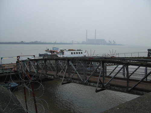
Chesterton is less than kind to Gravesend: having approached it by ferry from across the river he finds that it's less attractive than it looks from afar, compared to Tilbury, its opposite number on the north bank, which is the opposite. The town isn't helped by its rather morbid-sounding name, though the derivation is from "grove" not "grave", and it has its points of interest as you'd expect from a place with a maritime history. Some pleasant old streets and bits of proud Victoriana such as a fine clock tower mix with shopping malls and the endlessly fascinating river. The river is its inescapable link to London and the defining feature of the town's development -- the last major town on the straight run of the river from London before it becomes entangled in the complications of the Medway and the Swale, for centuries it was the terminal of passenger traffic from the capital along the river and its boatmen enjoyed important rights to operate this traffic. The Victorian era brought leisure traffic and the town became something of a resort. This shipping was traditionally controlled from London, and still is: the Port of London Authority's territory extends far downstream from here. These days the town is even more deeply in London's shadow, though the comings and goings are by train and car.
The Tilbury ferry, which accepts pedestrians and two-wheelers only, also enjoys a long history, though we'll consider this in more detail when we finally use it to complete our circuit in 328km time. It is the lowest established crossing point of the Thames and therefore a natural destination for walking routes. The Countryway passes through and the Wealdway starts here -- more of the latter later. The Saxon Shore Way also starts here, running eastwards along the shoreline as it was in Roman times, and all the way round to Hastings -- this connects with the E9 European Coastal Path and if you walked downstream from the ferry terminal you could continue on signed paths for over 1000km all the way round to Minehead, Somerset. There is a long term aspiration to extend the Thames Path from the edge of London to here, and there are already enough paths on or near the river for a reasonably satisfactory walk upriver to connect with the Thames Path Extension, which we may well explore on a later walk.
Gravesend would certainly make a more satisfactory end to the Thames Path than the arbitrary cutoff point of the National Trail at the Thames Barrier, or fizzling out in Crayford Marshes as the extension does. The river here is broad and clearly estuarine, with a very distinct tang of the sea. The ferry is closed on Sundays and the terminal is quiet, its white boats moored on their creaking little pier, while the cranes of Tilbury loom through the mist opposite. Elizabeth Gardens, the little square by the ferry pier, is little more than a few benches and paving. The adjoining pub bears the name Rum Punch -- doubtless the Trumans ales and bar billiards Chesterton found there when it was still the New Falcon are long gone.
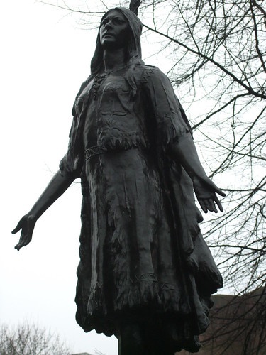
Gravesend's main claim to fame, though -- at least since 1995 when Disney released its romanticised and largely fabricated version of the story -- is as the last resting place of Princess Pocohontas (1595-1617). From the Powhawtan Confederacy in Virginia, Pocohantas allegedly saved the life of English colonist John Smith, later meeting and marrying tobacco grower John Rolfe, who brought her to England in 1616, where she lived with him in Brentford, on the Capital Ring. Next year the Rolfes took ship from London back to Virginia, but Pocohontas became ill, perhaps of pneumonia or smallpox, just off Gravesend, where she was taken ashore and soon died. The town has been quick to capitalise on her post-Disney fame -- even the ferryboat is now named after her. The life size bronze statue in the churchyard of St George's Church (a handsome building with an imposing square tower, built in 1732, over a century after her death, and it's by no means certain she's buried in its precints) dates from 1958 and a more dignified memorial. It's actually a replica of one at Jamestown, VA, sculpted by William Ordway Partridge in 1922, but to me it bears a strangely appropriate resemblance to a ship's figurehead, looking out across the river.
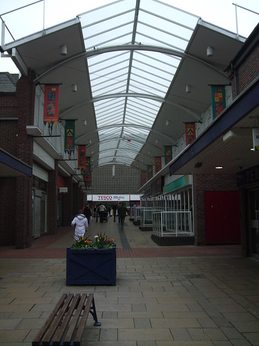
Behind the church and the Princess's statue, Chesterton's route splits off left with the Wealdway, following Princes Street and Stone Street and continuing for a good distance along busy Wrotham Road. The developers of these routes clearly took the view that urban walking should be avoided wherever possible, and if unavoidable it should take the shortest possible route no matter how busy -- the guidebook writers even suggest taking the bus to avoid this stretch. I'd rather complete the walk under my own power, and try to find a quieter and more interesting urban alternative. I find myself heading through St George's Shopping Centre, the bigger of Gravesend's town centre malls -- the succession of bargain and "pound" shops indicates we're far from the stockbroker belt of the Garden of England.
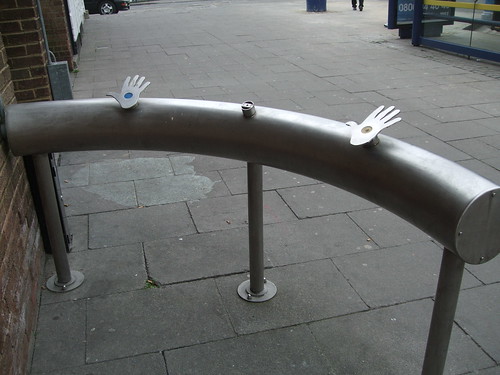
The split level mall provides a direct route more or less straight to the station, passing bus stops that promise a much more intense retail experience -- on Barracks Road beside Tesco you can catch a shuttle bus to the massive Bluewater centre, one of two huge retail parks on London's eastern estuarine edge. Malls are a pedestrian environment of sorts, though Bluewater is too far flung -- we might however encounter its arch rival on the Essex side, Lakeside Thurrock, on a later walk. A curious sculpture is by the bus stops -- a curved steel railing with two hand-shaped panels, previously three but one seems to have gone missing. There's no explanation for this piece -- it reminds me of some handprint-controlled gadget from the imagination of a science fiction writer.
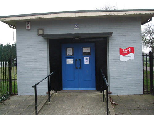
Past a tiny public space on a corner site, clearly popular with street drinkers, I pass an imposing civic statue of Queen Victoria and strike south down Darnley Road, a relatively quiet and pleasant enough Victorian residential street. Darnley Road becomes Dashwood Road and passes two green spaces -- I find myself walking along the grass just inside them. Dashwood Road Open Space is an area of grass adjacent to some cemeteries; Woodlands Park is a proper urban park with a bowling green, play area and pitches, well used though it could do with sprucing up. It has a rolling sweep to it which is attractive enough, and I later discover it conceals a cold war era bunker which is open for booked visits only. The notion that bureaucrats might survive the nuclear holocaust below a modest little park in Gravesend seems bizarre. Another curiosity is the tiny library by the park's northwest gate.
From the map I spot a lengthy off-road track that at first runs between houses then turns out to follow the edge of a broad, sweeping field. The track is unnamed and not shown as a right of way, but there's nothing to deter the public and people are out walking their dogs. The first stretch is the sort of place where stolen cars are immolated and unwanted mattresses left to decay but most of that is soon left behind and the sweeping view is impressive. On the other side I can see Wrotham Road, full of traffic, and congratulate myself on choosing this route. Eventually the path bends, passing a thatched cottage, to join this road -- the main access route south of the town -- and I join the Wealdeway just before Tollgate Junction.
This is the first of several encounters I plan to make with the alignment of Watling Street, originally a Celtic trackway that was then Romanised as the main east-west route between London and Dover (and on via ferry to Rome) and the route Chaucer's pilgrims would have followed to Canterbury, which crosses the north-south line of Wrotham Road here. For much of its length, including here, Watling Street has become incorporated into the modern road system, as the A2 trunk road. By the early 1980s this was a dual carriageway on a flyover with a roundabout beneath which Chesterton negotiates relatively easily. In 2003 the Channel Tunnel Rail Link, now known as High Speed 1, was built parallel to the A2, crossing Wrotham Road on another flyover, with a footbridge for the Wealdway. Then the footpath connecting this was obliterated by a new scheme for the A2, abandoning the dual carriageway in favour of two new viaducts each carrying three lanes of traffic.
New footpaths and cycleways are being installed as part of this scheme but I discover that, although already signed, they're not yet open and still officially form part of the building site. I spot that some locals have nonetheless breached the rather half-hearted defences and are already walking the paths, so I decide to see if I can get through. I find myself passing a garage with a Spar shop -- this used to be right next to A2's eastbound carriageway and was sometimes a stop on car journeys to visit my family near Canterbury, but the owners must rue the new works, as it's now set well back from the traffic. Its fate is not quite so severe as the cutesy mock-Tudor 1930s motel opposite, marooned in boarded up stasis within the building site.
I find myself exploring several parallel and layered alignments of this ancient way, partly obliterated like a succession of half-erased pencil sketches. Old Watling Street climbs an embankment to my left, created when the road was levelled through a cutting. To my right the spoil from the works has been landscaped, with saplings protected by tubes, but you can still see the traces of road markings underfoot. Presumably somewhere below all this is the Roman agger and pavement. Finally a succession of barriers on the new footbridges across road and railway defeats me and I loop back along a path that was once clearly a footway along a previous incarnation of the road. The whole place has an unfinished, rubble-strewn feel, half-completed and waiting to be filled. I'll be interested to return at some point but I quite like it as it is now -- I hope they don't erase all the traces.
I'm now forced along the Wealdway interim route, alongside traffic under viaducts, round roundabouts and finally an awkward and desultory verge behind a crash barrier to reach a track running parallel to High Speed 1, Britain's first purpose-built high speed line. It's a curiously clean edged, featureless piece of work, essentially a French ligne à grande vitesse protruding into England, complete with French signalling and trackside signing. I hear the distinctive whistle of Eurostar trains while approaching and leaving, but they fail to oblige when I'm actually walking alongside the line.
Turning away from the line, I'm now decisively on the Wealdway, in the surroundings of a more typical countryside walk -- flat Kentish fields and hedgerows, pylons, and ahead of me a fine 18th century country house, Ifield Court, with the distinctive cowls of oast houses off to the left. Here Chesterton points out a path that will take you directly to Cobham, a nearby village with several celebrated buildings including a National Trust property, and Dickensian connections. He speculates that the route through Cobham may be even better than his main route. But it takes us too far out of our way, and my back is still playing up -- I'm regretting buying a 2l bottle of own brand water because it was cheaper than the 1.5l branded bottles at Tesco, as it's now weighing me down. There will be plenty more Dickensian heritage to come.
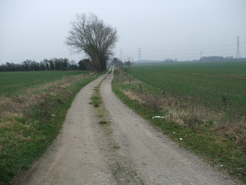
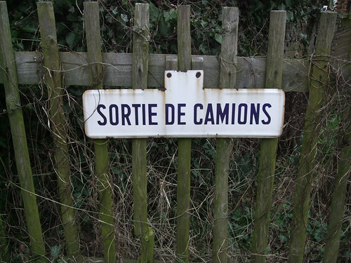
A clear path between fields, presumably once following a hedgerow that's long since been grubbed up, emerges in the cluster of houses known as Nash Street. I meet a lone Explorer map-equipped walker heading in the opposite direction, pass Shepherd's Cottage, although this isn't sheep country, and a chocolate box half-timbered house called simply "The Cottage". A sign on a gateway says "Sortie de camions". A few hundred metres from High Speed 1, is this a deliberate Anglo-French gesture? I look for camions but the biggest vehicles in sight are 4x4s.
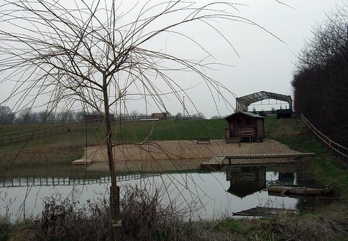
The bridleway ahead becomes a classic green lane, following a slightly sunken course through the centre of a woodland strip, and on one uphill stretch I notice white nuggets among the flints on the path surface -- our first encounter with chalk, and by no means our last, as it will dominate the geology of many future walks. I meet two women on horseback -- the leading horse, a handsome chestnut stallion, starts and refuses to pass me. "He's scared of you for some reason," says the rider. I can't think why this animal several times my size and strength should be scared of me, and pass by slowly. I realise we're in equestrian territory, with horses grazing in surrounding paddocks scattered with jumps. This is now one of the characteristic semi-rural landscapes of London's periphery -- no longer economic agricultural land is given over to stables, riding schools and stud farms for the benefit of the children of the capital's rich, with just enough of the old rural character kept to indulge a little bucolic fantasy. By the side of an oversized puddle of a pond, someone has created a pebbly beach complete with beach hut, nicely offset by spindly leafless trees. It looks cutely fake, a display in a garden centre or a set for a Mediterranean beach scene in a 1960s British comedy shot on a backlot at chilly Pinewood in March.
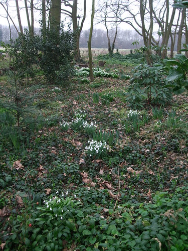
The final stage around the edge of Sole Street includes a path through a lovely woodland, with thick clusters of snowdrops blossoming in early March, and barbecue furniture, presumably belonging to the houses that back onto the path.
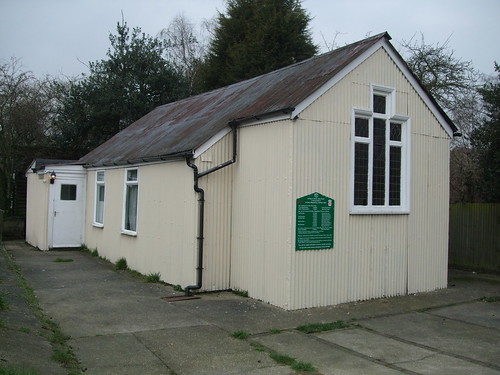
This emerges into Manor Road, a street of bungalows, one of which is curiously derelict, and at the corner with Sole Street, a corrugated iron hut that houses a church meeting room, looking like something from a World War II exhibition.
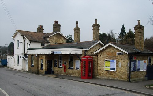
There are more horses crossing the railway line, a place called "The Little Shop" (Tubbs and Edward from The League of Gentlemen have given the proprietors of such places something to live up to), and the modest but attractive 1861 station built by the London, Chatham and Dover Railway, but otherwise I see little of Sole Street. It's been a varied but unspectacular stroll and a good start.


No comments:
Post a Comment